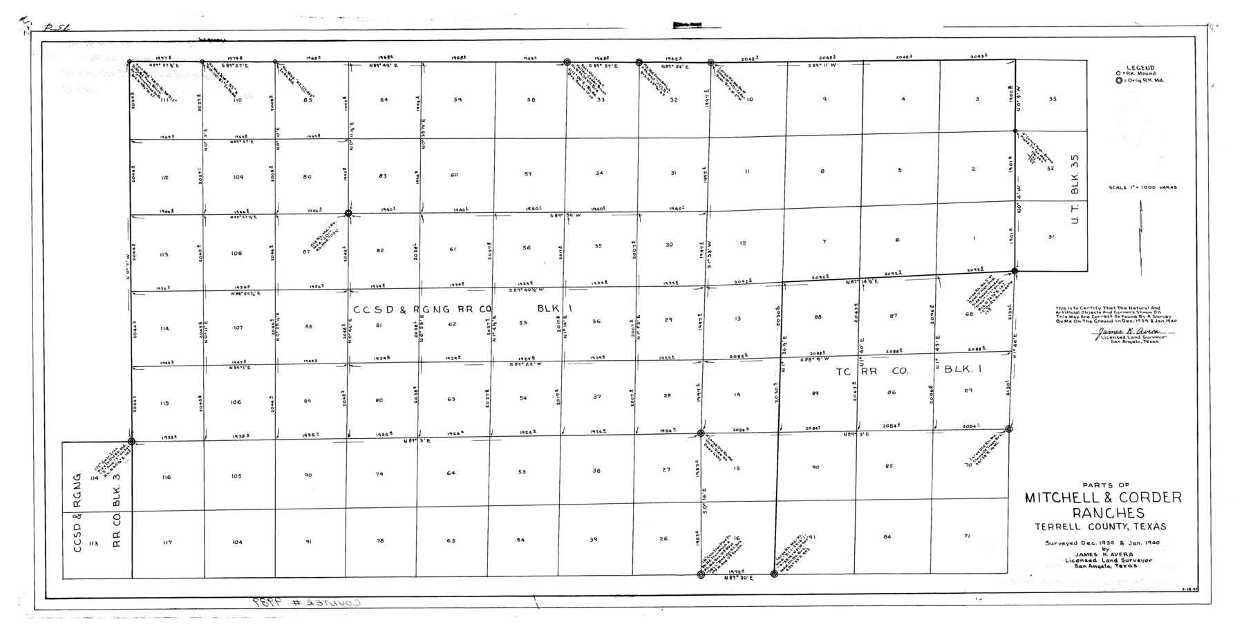
Terrell County Rolled Sketch 36
Parts of Mitchell & Corder Ranches, Terrell County, Texas
- 
                          Map/Doc
9989
 - 
                            Collection
General Map Collection
 - 
                            Object Dates
1940 (Survey Date)
1940/3/28 (File Date)
1940/3/18 (Creation Date)
 - 
                            People and Organizations
James K. Avera (Surveyor/Engineer)
 - 
                            Counties
Terrell
 - 
                            Subjects
Surveying Rolled Sketch
 - 
                            Height x Width
17.4 x 33.8 inches
44.2 x 85.9 cm
 - 
                            Scale
1" = 1000 varas
 
Related maps
            Terrell County Sketch File 29


                                            Print $6.00                    
                                             -                         Digital $50.00                                    
                Terrell County Sketch File 29
1940
Size 11.2 x 8.8 inches
                                Map/Doc 37976
            Part of: General Map Collection
            Map of the lower surveys in Robertsons Colony Sold by the State of Coahuila and Texas


                                            Print $20.00                    
                                             -                         Digital $50.00                                    
                Map of the lower surveys in Robertsons Colony Sold by the State of Coahuila and Texas
1834
Size 22.0 x 28.5 inches
                                Map/Doc 122
            
            [Map of Located Land of Gulf, Colorado & Santa Fe Ry. Co. through Denton]


                                            Print $40.00                    
                                             -                         Digital $50.00                                    
                [Map of Located Land of Gulf, Colorado & Santa Fe Ry. Co. through Denton]
Size 122.8 x 28.3 inches
                                Map/Doc 64340
            
            Jack County Working Sketch 22


                                            Print $20.00                    
                                             -                         Digital $50.00                                    
                Jack County Working Sketch 22
1995
Size 23.9 x 36.7 inches
                                Map/Doc 66448
            
            Nueces County Rolled Sketch 32


                                            Print $20.00                    
                                             -                         Digital $50.00                                    
                Nueces County Rolled Sketch 32
Size 17.0 x 17.2 inches
                                Map/Doc 6876
            
            Flight Mission No. CRC-3R, Frame 200, Chambers County


                                            Print $20.00                    
                                             -                         Digital $50.00                                    
                Flight Mission No. CRC-3R, Frame 200, Chambers County
1956
Size 18.6 x 22.2 inches
                                Map/Doc 84855
            
            Hardeman County


                                            Print $20.00                    
                                             -                         Digital $50.00                                    
                Hardeman County
1935
Size 44.4 x 41.4 inches
                                Map/Doc 73170
            
            Sabine County Rolled Sketch 2


                                            Print $20.00                    
                                             -                         Digital $50.00                                    
                Sabine County Rolled Sketch 2
1949
Size 33.3 x 20.8 inches
                                Map/Doc 7551
            
            Liberty County Rolled Sketch 15


                                            Print $20.00                    
                                             -                         Digital $50.00                                    
                Liberty County Rolled Sketch 15
2015
Size 36.1 x 24.3 inches
                                Map/Doc 94022
            
            Presidio County Working Sketch 19


                                            Print $20.00                    
                                             -                         Digital $50.00                                    
                Presidio County Working Sketch 19
1943
Size 32.9 x 40.3 inches
                                Map/Doc 71695
            
            Flight Mission No. DAG-24K, Frame 49, Matagorda County


                                            Print $20.00                    
                                             -                         Digital $50.00                                    
                Flight Mission No. DAG-24K, Frame 49, Matagorda County
1953
Size 18.5 x 22.2 inches
                                Map/Doc 86536
            
            McCulloch County Boundary File 3


                                            Print $16.00                    
                                             -                         Digital $50.00                                    
                McCulloch County Boundary File 3
Size 11.1 x 8.6 inches
                                Map/Doc 56911
            
            Orange County Working Sketch 27


                                            Print $20.00                    
                                             -                         Digital $50.00                                    
                Orange County Working Sketch 27
1953
Size 31.0 x 22.9 inches
                                Map/Doc 71359
            You may also like
            [Beaumont, Sour Lake and Western Ry. Right of Way and Alignment - Frisco]


                                            Print $20.00                    
                                             -                         Digital $50.00                                    
                [Beaumont, Sour Lake and Western Ry. Right of Way and Alignment - Frisco]
1910
Size 19.9 x 45.9 inches
                                Map/Doc 64108
            
            Blanco County Boundary File 5


                                            Print $100.00                    
                                             -                         Digital $50.00                                    
                Blanco County Boundary File 5
Size 17.1 x 14.1 inches
                                Map/Doc 50555
            
            Coleman County Working Sketch 3


                                            Print $20.00                    
                                             -                         Digital $50.00                                    
                Coleman County Working Sketch 3
1918
Size 27.1 x 29.2 inches
                                Map/Doc 68069
            
            Sabine and Neches Rivers


                                            Print $20.00                    
                                             -                         Digital $50.00                                    
                Sabine and Neches Rivers
Size 19.6 x 43.7 inches
                                Map/Doc 94444
            
            Jasper County Rolled Sketch 8


                                            Print $3.00                    
                                             -                         Digital $50.00                                    
                Jasper County Rolled Sketch 8
Size 17.7 x 11.9 inches
                                Map/Doc 6357
            
            Flight Mission No. DCL-6C, Frame 133, Kenedy County


                                            Print $20.00                    
                                             -                         Digital $50.00                                    
                Flight Mission No. DCL-6C, Frame 133, Kenedy County
1943
Size 18.6 x 22.3 inches
                                Map/Doc 85963
            
            Montague County Sketch File 25


                                            Print $8.00                    
                                             -                         Digital $50.00                                    
                Montague County Sketch File 25
1942
Size 11.2 x 8.8 inches
                                Map/Doc 31756
            
            Map of Atascosa County


                                            Print $20.00                    
                                             -                         Digital $50.00                                    
                Map of Atascosa County
1879
Size 24.5 x 24.8 inches
                                Map/Doc 3250
            
            Borden County Working Sketch 1a and 1b


                                            Print $20.00                    
                                             -                         Digital $50.00                                    
                Borden County Working Sketch 1a and 1b
1890
Size 16.2 x 18.0 inches
                                Map/Doc 67461
            
            Leon County Rolled Sketch 23


                                            Print $20.00                    
                                             -                         Digital $50.00                                    
                Leon County Rolled Sketch 23
1981
Size 33.6 x 40.7 inches
                                Map/Doc 6609
            
            Gray County Boundary File 7


                                            Print $4.00                    
                                             -                         Digital $50.00                                    
                Gray County Boundary File 7
Size 8.0 x 8.8 inches
                                Map/Doc 53898
            
            Borden County Boundary File 4


                                            Print $66.00                    
                                             -                         Digital $50.00                                    
                Borden County Boundary File 4
1908
Size 23.7 x 125.7 inches
                                Map/Doc 1694