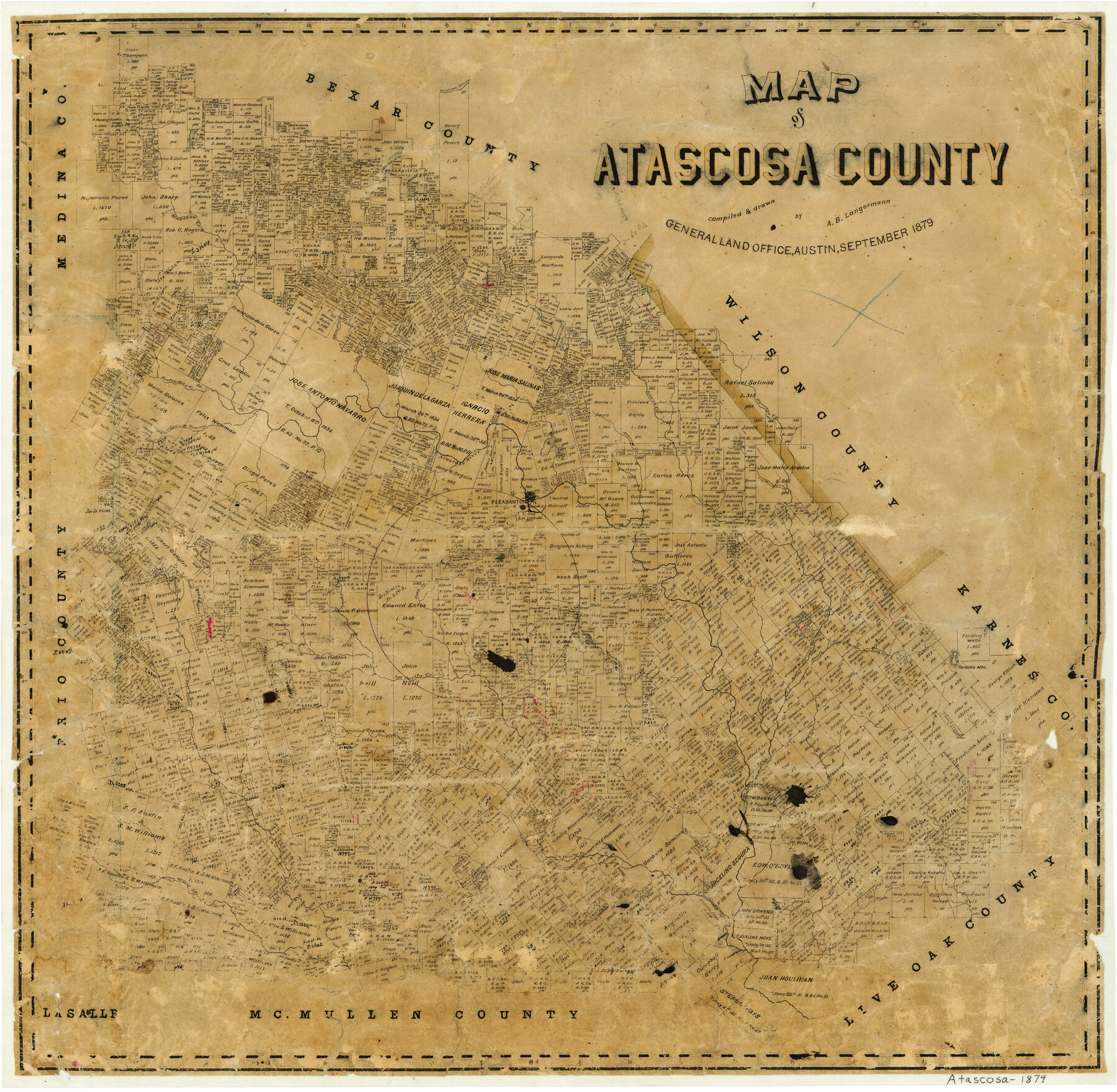
Map of Atascosa County
-
Map/Doc
3250
-
Collection
General Map Collection
-
Object Dates
9/1879 (Creation Date)
-
People and Organizations
A.B. Langermann (Compiler)
A.B. Langermann (Draftsman)
-
Counties
Atascosa
-
Subjects
County
-
Height x Width
24.5 x 24.8 inches
62.2 x 63.0 cm
-
Comments
Best candidate for copy. Nine black ink spots.
-
Features
Panther Creek
Lepan Creek
San Miguel Creek
Bell Creek
Salt Creek
Salinas Creek
Arroyo de Galvan
Las Priedas Creek
Clear Creek
Turkey Creek
Stoney Creek
East Matador Creek
Lagunieras Creek
Chiquihuitilla Creek
Maline Creek
Branch Creek
San Miguel Creek
Atascosa River
Atascosa Creek
Agua Negra
Sand Creek
Sesteadero Creek
Palo Alto Creek
Gallinas Creek
Lucus Creek
Borrego Creek
Medina River
Avarias Creek
Cañada de Padilla
Pleasanton
Goose Creek
La Parita Creek
Tordillo Creek
Tordilla Mountain
Part of: General Map Collection
Coryell County

Print $20.00
- Digital $50.00
Coryell County
1936
Size 44.6 x 40.1 inches
Map/Doc 77249
Edwards County Rolled Sketch 15

Print $20.00
- Digital $50.00
Edwards County Rolled Sketch 15
1893
Size 35.5 x 26.4 inches
Map/Doc 5803
Val Verde County Sketch File Z21

Print $20.00
- Digital $50.00
Val Verde County Sketch File Z21
Size 18.3 x 17.3 inches
Map/Doc 12560
Stephens County Working Sketch 8

Print $20.00
- Digital $50.00
Stephens County Working Sketch 8
1920
Size 21.0 x 28.7 inches
Map/Doc 63951
Jeff Davis County Sketch File 15

Print $20.00
- Digital $50.00
Jeff Davis County Sketch File 15
1883
Size 28.5 x 18.9 inches
Map/Doc 11859
Jones County Sketch File 14

Print $4.00
- Digital $50.00
Jones County Sketch File 14
1882
Size 11.7 x 8.8 inches
Map/Doc 28501
Young County Working Sketch 9

Print $20.00
- Digital $50.00
Young County Working Sketch 9
1921
Size 25.9 x 36.6 inches
Map/Doc 62032
Leon County Sketch File 38

Print $10.00
- Digital $50.00
Leon County Sketch File 38
1999
Size 11.0 x 8.5 inches
Map/Doc 29878
Harris County NRC Article 33.136 Sketch 21

Print $38.00
Harris County NRC Article 33.136 Sketch 21
2024
Map/Doc 97295
Flight Mission No. DQN-7K, Frame 4, Calhoun County

Print $20.00
- Digital $50.00
Flight Mission No. DQN-7K, Frame 4, Calhoun County
1953
Size 18.9 x 22.1 inches
Map/Doc 84455
Flight Mission No. CGI-3N, Frame 134, Cameron County

Print $20.00
- Digital $50.00
Flight Mission No. CGI-3N, Frame 134, Cameron County
1954
Size 18.4 x 22.2 inches
Map/Doc 84607
Flight Mission No. DAG-28K, Frame 30, Matagorda County

Print $20.00
- Digital $50.00
Flight Mission No. DAG-28K, Frame 30, Matagorda County
1953
Size 16.1 x 16.1 inches
Map/Doc 86598
You may also like
Starr County Sketch File 4

Print $3.00
- Digital $50.00
Starr County Sketch File 4
Size 9.3 x 11.5 inches
Map/Doc 36857
Flight Mission No. CRK-8P, Frame 122, Refugio County

Print $20.00
- Digital $50.00
Flight Mission No. CRK-8P, Frame 122, Refugio County
1956
Size 18.4 x 22.1 inches
Map/Doc 86977
Brewster County Rolled Sketch 158

Print $20.00
- Digital $50.00
Brewster County Rolled Sketch 158
2007
Size 24.6 x 36.5 inches
Map/Doc 89623
Map of Tom Green County

Print $20.00
- Digital $50.00
Map of Tom Green County
1892
Size 44.1 x 47.5 inches
Map/Doc 78389
Calhoun County Rolled Sketch 28B

Print $7.00
- Digital $50.00
Calhoun County Rolled Sketch 28B
1834
Size 10.5 x 15.4 inches
Map/Doc 43684

Flight Mission No. CLL-1N, Frame 87, Willacy County

Print $20.00
- Digital $50.00
Flight Mission No. CLL-1N, Frame 87, Willacy County
1954
Size 18.3 x 22.0 inches
Map/Doc 87033
Jeff Davis County Working Sketch 11

Print $20.00
- Digital $50.00
Jeff Davis County Working Sketch 11
1947
Size 23.3 x 43.1 inches
Map/Doc 66506
Kimble County Working Sketch 7

Print $20.00
- Digital $50.00
Kimble County Working Sketch 7
1917
Size 12.6 x 16.8 inches
Map/Doc 70075

Crane County Rolled Sketch 15

Print $40.00
- Digital $50.00
Crane County Rolled Sketch 15
1946
Size 27.2 x 49.5 inches
Map/Doc 8682
Montgomery County Working Sketch 26

Print $20.00
- Digital $50.00
Montgomery County Working Sketch 26
1941
Size 40.8 x 30.7 inches
Map/Doc 71133