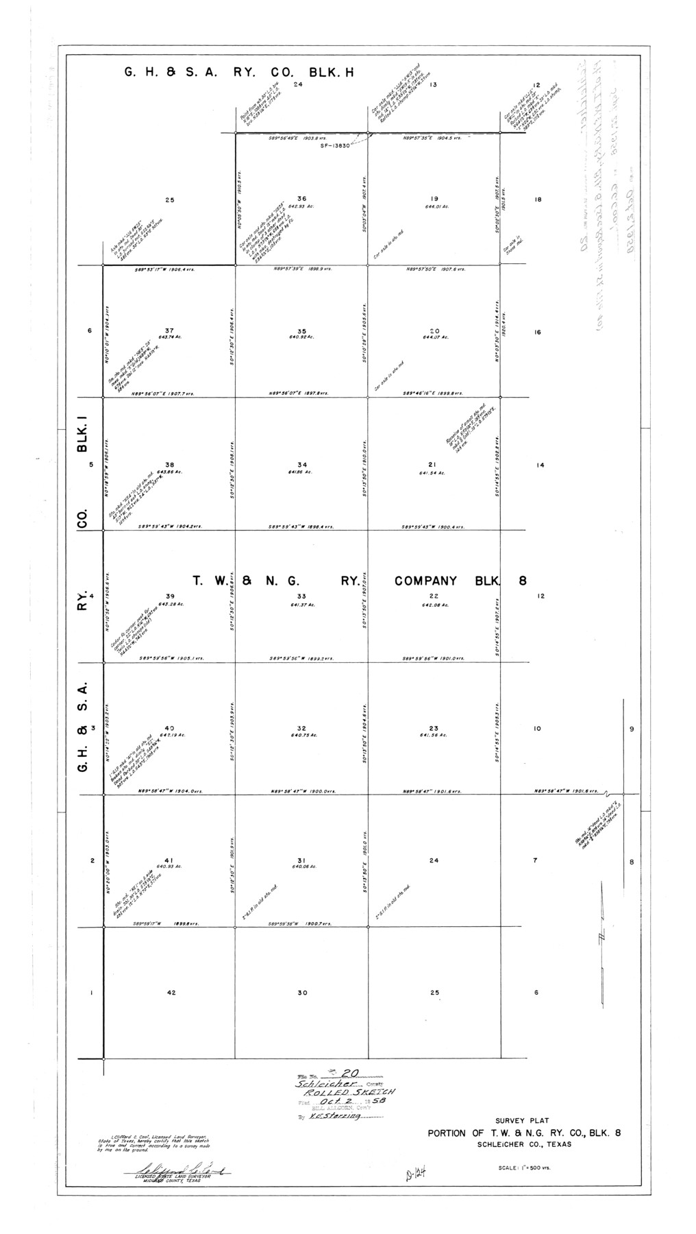
Schleicher County Rolled Sketch 20
Survey plat, portion of T. W. & N. G. Ry. Co., Blk. 8, Schleicher Co., Texas
- 
                          Map/Doc
9906
 - 
                            Collection
General Map Collection
 - 
                            Object Dates
1958/9/22 (Creation Date)
1958/10/2 (File Date)
 - 
                            People and Organizations
Clifford C. Cool (Surveyor/Engineer)
 - 
                            Counties
Schleicher
 - 
                            Subjects
Surveying Rolled Sketch
 - 
                            Height x Width
35.5 x 20.0 inches
90.2 x 50.8 cm
 - 
                            Scale
1" = 500 varas
 - 
                            Comments
See Schleicher County Sketch File 40 (36541) for surveyor's report.
 
Related maps
            Schleicher County Sketch File 40


                                            Print $6.00                    
                                             -                         Digital $50.00                                    
                Schleicher County Sketch File 40
1958
Size 11.2 x 8.9 inches
                                Map/Doc 36541
            Part of: General Map Collection
            Young County Sketch File 10c


                                            Print $4.00                    
                                             -                         Digital $50.00                                    
                Young County Sketch File 10c
1878
Size 8.2 x 15.4 inches
                                Map/Doc 40872
            
            Motley County Sketch File 19 (N)


                                            Print $24.00                    
                                             -                         Digital $50.00                                    
                Motley County Sketch File 19 (N)
1940
Size 14.2 x 8.8 inches
                                Map/Doc 32064
            
            Roberts County Rolled Sketch 3


                                            Print $40.00                    
                                             -                         Digital $50.00                                    
                Roberts County Rolled Sketch 3
Size 38.4 x 50.0 inches
                                Map/Doc 8358
            
            Tyler County Rolled Sketch 9


                                            Print $20.00                    
                                             -                         Digital $50.00                                    
                Tyler County Rolled Sketch 9
Size 43.3 x 25.6 inches
                                Map/Doc 8059
            
            Flight Mission No. BRE-1P, Frame 104, Nueces County


                                            Print $20.00                    
                                             -                         Digital $50.00                                    
                Flight Mission No. BRE-1P, Frame 104, Nueces County
1956
Size 18.4 x 22.2 inches
                                Map/Doc 86675
            
            La Salle County Sketch File 22


                                            Print $4.00                    
                                             -                         Digital $50.00                                    
                La Salle County Sketch File 22
1875
Size 12.8 x 8.2 inches
                                Map/Doc 29528
            
            Swisher County


                                            Print $20.00                    
                                             -                         Digital $50.00                                    
                Swisher County
1941
Size 45.2 x 38.0 inches
                                Map/Doc 63055
            
            Castro County Boundary File 1 and 1a


                                            Print $44.00                    
                                             -                         Digital $50.00                                    
                Castro County Boundary File 1 and 1a
Size 8.9 x 9.9 inches
                                Map/Doc 51186
            
            Roberts County Working Sketch 11


                                            Print $40.00                    
                                             -                         Digital $50.00                                    
                Roberts County Working Sketch 11
1966
Size 57.6 x 38.6 inches
                                Map/Doc 63537
            
            Freestone County Working Sketch 25


                                            Print $20.00                    
                                             -                         Digital $50.00                                    
                Freestone County Working Sketch 25
1984
Size 43.5 x 38.4 inches
                                Map/Doc 69267
            
            VanZandt County Showing the Located Route of the Texas and Pacific R.R.


                                            Print $20.00                    
                                             -                         Digital $50.00                                    
                VanZandt County Showing the Located Route of the Texas and Pacific R.R.
1872
Size 24.5 x 22.3 inches
                                Map/Doc 64136
            
            Flight Mission No. BRE-2P, Frame 39, Nueces County


                                            Print $20.00                    
                                             -                         Digital $50.00                                    
                Flight Mission No. BRE-2P, Frame 39, Nueces County
1956
Size 18.6 x 22.4 inches
                                Map/Doc 86741
            You may also like
            Jefferson County Sketch File 25


                                            Print $14.00                    
                                             -                         Digital $50.00                                    
                Jefferson County Sketch File 25
1896
Size 7.6 x 6.7 inches
                                Map/Doc 28184
            
            Right of Way and Track Map, the Missouri, Kansas and Texas Ry. of Texas - Henrietta Division


                                            Print $20.00                    
                                             -                         Digital $50.00                                    
                Right of Way and Track Map, the Missouri, Kansas and Texas Ry. of Texas - Henrietta Division
1918
Size 11.8 x 27.0 inches
                                Map/Doc 64761
            
            Hydrographic Survey H-6396 of Outer Coast of Padre Island; Gulf of Mexico


                                            Print $40.00                    
                                             -                         Digital $50.00                                    
                Hydrographic Survey H-6396 of Outer Coast of Padre Island; Gulf of Mexico
1938
Size 55.4 x 34.0 inches
                                Map/Doc 2698
            
            Brewster County Sketch File 56


                                            Print $14.00                    
                                             -                         Digital $50.00                                    
                Brewster County Sketch File 56
2001
Size 11.0 x 8.5 inches
                                Map/Doc 16392
            
            Stonewall County Working Sketch 14


                                            Print $20.00                    
                                             -                         Digital $50.00                                    
                Stonewall County Working Sketch 14
1951
Size 22.2 x 37.1 inches
                                Map/Doc 62321
            
            Coast Chart No. 210 Aransas Pass and Corpus Christi Bay with the coast to latitude 27° 12' Texas


                                            Print $20.00                    
                                             -                         Digital $50.00                                    
                Coast Chart No. 210 Aransas Pass and Corpus Christi Bay with the coast to latitude 27° 12' Texas
1913
Size 27.0 x 18.2 inches
                                Map/Doc 72800
            
            [I. & G. N. RR. Co. Block I]


                                            Print $20.00                    
                                             -                         Digital $50.00                                    
                [I. & G. N. RR. Co. Block I]
Size 43.0 x 31.7 inches
                                Map/Doc 89828
            
            Gregg County School Land League 2


                                            Print $20.00                    
                                             -                         Digital $50.00                                    
                Gregg County School Land League 2
Size 15.6 x 15.5 inches
                                Map/Doc 90613
            
            Kendall County Boundary File 3


                                            Print $36.00                    
                                             -                         Digital $50.00                                    
                Kendall County Boundary File 3
Size 9.4 x 37.5 inches
                                Map/Doc 55756
            
            Pecos County Rolled Sketch 44A


                                            Print $20.00                    
                                             -                         Digital $50.00                                    
                Pecos County Rolled Sketch 44A
1912
Size 19.7 x 34.6 inches
                                Map/Doc 7223
            
            Erath County Sketch File A2


                                            Print $20.00                    
                                             -                         Digital $50.00                                    
                Erath County Sketch File A2
Size 15.9 x 19.5 inches
                                Map/Doc 11464
            
            Outer Continental Shelf Leasing Maps (Louisiana Offshore Operations)


                                            Print $20.00                    
                                             -                         Digital $50.00                                    
                Outer Continental Shelf Leasing Maps (Louisiana Offshore Operations)
1959
Size 13.7 x 17.4 inches
                                Map/Doc 76116