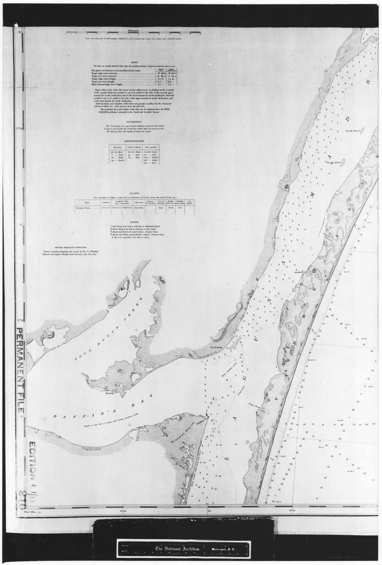
Coast Chart No. 210 Aransas Pass and Corpus Christi Bay with the coast to latitude 27° 12' Texas
RL-2-10b
-
Map/Doc
72800
-
Collection
General Map Collection
-
Object Dates
1913 (Creation Date)
-
People and Organizations
Coast and Geodetic Survey (Publisher)
-
Counties
Nueces
-
Subjects
Nautical Charts
-
Height x Width
27.0 x 18.2 inches
68.6 x 46.2 cm
-
Comments
B/W photostat copy from National Archives in multiple pieces.
Part of: General Map Collection
Terrell County Rolled Sketch 49

Print $20.00
- Digital $50.00
Terrell County Rolled Sketch 49
1962
Size 17.3 x 24.1 inches
Map/Doc 7951
Nolan County Rolled Sketch 2

Print $20.00
- Digital $50.00
Nolan County Rolled Sketch 2
1956
Size 27.7 x 35.0 inches
Map/Doc 6860

[Abstract Numbering Register - Kaufman through Reagan]
![82967, [Abstract Numbering Register - Kaufman through Reagan], General Map Collection](https://historictexasmaps.com/wmedia_w700/pdf_converted_jpg/qi_pdf_thumbnail_30614.jpg)
[Abstract Numbering Register - Kaufman through Reagan]
Map/Doc 82967
Cooke County Boundary File 1a

Print $32.00
- Digital $50.00
Cooke County Boundary File 1a
Size 12.6 x 7.5 inches
Map/Doc 51828
Wichita County Working Sketch 23

Print $20.00
- Digital $50.00
Wichita County Working Sketch 23
1963
Size 28.4 x 30.8 inches
Map/Doc 72533
Edwards County Sketch File 28

Print $5.00
- Digital $50.00
Edwards County Sketch File 28
Size 27.3 x 25.6 inches
Map/Doc 11431
Map of Bexar County

Print $20.00
- Digital $50.00
Map of Bexar County
1878
Size 23.5 x 26.6 inches
Map/Doc 3299

Flight Mission No. BRA-3M, Frame 195, Jefferson County

Print $20.00
- Digital $50.00
Flight Mission No. BRA-3M, Frame 195, Jefferson County
1953
Size 18.6 x 22.3 inches
Map/Doc 85410
Brewster County Rolled Sketch 92

Print $20.00
- Digital $50.00
Brewster County Rolled Sketch 92
1950
Size 24.3 x 15.2 inches
Map/Doc 5250
Bastrop County Boundary File 5

Print $18.00
- Digital $50.00
Bastrop County Boundary File 5
Size 9.1 x 7.2 inches
Map/Doc 50328
You may also like
Jeff Davis County Sketch File 26 1/2

Print $10.00
- Digital $50.00
Jeff Davis County Sketch File 26 1/2
Size 9.0 x 10.4 inches
Map/Doc 27999
Mills County Boundary File 7

Print $2.00
- Digital $50.00
Mills County Boundary File 7
Size 14.2 x 8.6 inches
Map/Doc 57312
Flight Mission No. BRA-17M, Frame 8, Jefferson County

Print $20.00
- Digital $50.00
Flight Mission No. BRA-17M, Frame 8, Jefferson County
1953
Size 18.6 x 22.3 inches
Map/Doc 85789
McMullen County Sketch File 24

Print $22.00
- Digital $50.00
McMullen County Sketch File 24
Size 8.7 x 12.6 inches
Map/Doc 31381
Tom Green County Working Sketch 3

Print $20.00
- Digital $50.00
Tom Green County Working Sketch 3
1933
Size 47.5 x 40.2 inches
Map/Doc 69372
Map of County Roads in Moore County

Print $20.00
- Digital $50.00
Map of County Roads in Moore County
Size 22.2 x 21.2 inches
Map/Doc 93005
Potter County Boundary File 6b

Print $20.00
- Digital $50.00
Potter County Boundary File 6b
Size 37.9 x 8.7 inches
Map/Doc 58040

[Subdivision plat of Crockett County School Land Leagues 214-217 and adjacent leagues]
![90253, [Subdivision plat of Crockett County School Land Leagues 214-217 and adjacent leagues], Twichell Survey Records](https://historictexasmaps.com/wmedia_w700/maps/90253-1.tif.jpg)
Print $20.00
- Digital $50.00
[Subdivision plat of Crockett County School Land Leagues 214-217 and adjacent leagues]
Size 26.9 x 19.0 inches
Map/Doc 90253
Kimble County Working Sketch 91

Print $20.00
- Digital $50.00
Kimble County Working Sketch 91
1979
Size 26.8 x 25.5 inches
Map/Doc 70159
PSL Field Notes for Blocks 87 through 98 in Culberson County

PSL Field Notes for Blocks 87 through 98 in Culberson County
Map/Doc 81664
Ector County Sketch File 1

Print $20.00
- Digital $50.00
Ector County Sketch File 1
1931
Size 17.1 x 18.0 inches
Map/Doc 11415