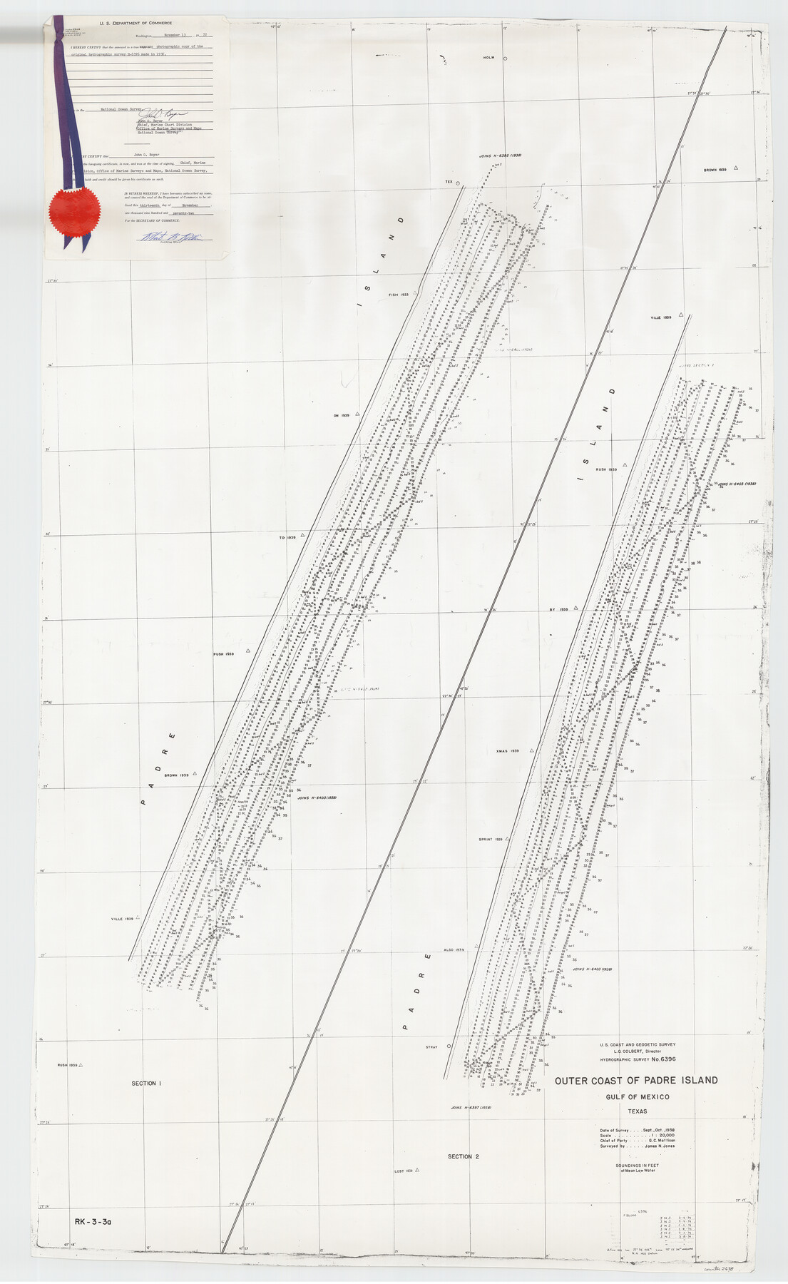
Hydrographic Survey H-6396 of Outer Coast of Padre Island; Gulf of Mexico
True photographic copy from National Ocean Survey
-
Map/Doc
2698
-
Collection
General Map Collection
-
Object Dates
1938 (Creation Date)
-
People and Organizations
U. S. Coast and Geodetic Survey (Author)
-
Subjects
Nautical Charts
-
Height x Width
55.4 x 34.0 inches
140.7 x 86.4 cm
-
Medium
photograph
-
Scale
:20,000
-
Comments
See 83365 for Certificate
Part of: General Map Collection
San Saba County Rolled Sketch 1

Print $3.00
- Digital $50.00
San Saba County Rolled Sketch 1
Size 11.7 x 9.0 inches
Map/Doc 7742
Liberty County Working Sketch 81

Print $20.00
- Digital $50.00
Liberty County Working Sketch 81
1981
Size 8.0 x 24.2 inches
Map/Doc 70541
The State of Oklahoma

Print $20.00
- Digital $50.00
The State of Oklahoma
1916
Size 28.4 x 34.4 inches
Map/Doc 97104
Archer County Sketch File 13

Print $4.00
- Digital $50.00
Archer County Sketch File 13
Size 11.8 x 8.7 inches
Map/Doc 13648
Flight Mission No. CUG-3P, Frame 136, Kleberg County

Print $20.00
- Digital $50.00
Flight Mission No. CUG-3P, Frame 136, Kleberg County
1956
Size 18.5 x 22.3 inches
Map/Doc 86271
Shackelford County

Print $20.00
- Digital $50.00
Shackelford County
1972
Size 43.9 x 37.3 inches
Map/Doc 95638
Navarro County Sketch File 20

Print $14.00
- Digital $50.00
Navarro County Sketch File 20
1967
Size 14.3 x 8.8 inches
Map/Doc 32343
2008 Official Travel Map, Texas

2008 Official Travel Map, Texas
Size 33.5 x 36.4 inches
Map/Doc 94344
Bosque County Working Sketch 21

Print $40.00
- Digital $50.00
Bosque County Working Sketch 21
1984
Size 38.5 x 55.1 inches
Map/Doc 67454
Hutchinson County

Print $20.00
- Digital $50.00
Hutchinson County
1922
Size 44.4 x 36.5 inches
Map/Doc 73188
Trinity County Sketch File 5a

Print $4.00
- Digital $50.00
Trinity County Sketch File 5a
1853
Size 6.9 x 8.0 inches
Map/Doc 38504
Fannin County No. 2 McClure & M. H. Wright's map, Sulphur

Print $2.00
- Digital $50.00
Fannin County No. 2 McClure & M. H. Wright's map, Sulphur
1844
Size 8.4 x 8.1 inches
Map/Doc 69732
You may also like
Andrews County Working Sketch 11

Print $20.00
- Digital $50.00
Andrews County Working Sketch 11
1955
Size 20.6 x 25.2 inches
Map/Doc 67057
Wichita County Sketch File 12

Print $6.00
- Digital $50.00
Wichita County Sketch File 12
1881
Size 10.2 x 8.3 inches
Map/Doc 40074
Webb County Sketch File 11a-1

Print $27.00
- Digital $50.00
Webb County Sketch File 11a-1
1884
Size 22.2 x 9.3 inches
Map/Doc 12626
Trinity River, Wildcat Ferry Sheet

Print $20.00
- Digital $50.00
Trinity River, Wildcat Ferry Sheet
1928
Size 41.5 x 40.9 inches
Map/Doc 65182
San Jacinto County Working Sketch 34

Print $20.00
- Digital $50.00
San Jacinto County Working Sketch 34
1955
Size 25.2 x 25.2 inches
Map/Doc 63747
McMullen County Working Sketch 33

Print $20.00
- Digital $50.00
McMullen County Working Sketch 33
1959
Size 37.3 x 27.0 inches
Map/Doc 70734
Jackson County Sketch File 31

Print $18.00
- Digital $50.00
Jackson County Sketch File 31
1940
Size 14.4 x 8.4 inches
Map/Doc 27756
General Highway Map, Tyler County, Texas

Print $20.00
General Highway Map, Tyler County, Texas
1961
Size 24.8 x 18.1 inches
Map/Doc 79690
Hale County Sketch File 24

Print $22.00
- Digital $50.00
Hale County Sketch File 24
1908
Size 8.9 x 7.9 inches
Map/Doc 24761

Map of Brazoria

Print $20.00
- Digital $50.00
Map of Brazoria
1931
Size 20.2 x 26.7 inches
Map/Doc 80134
Brown County Sketch File 13

Print $40.00
- Digital $50.00
Brown County Sketch File 13
Size 17.9 x 33.1 inches
Map/Doc 11020