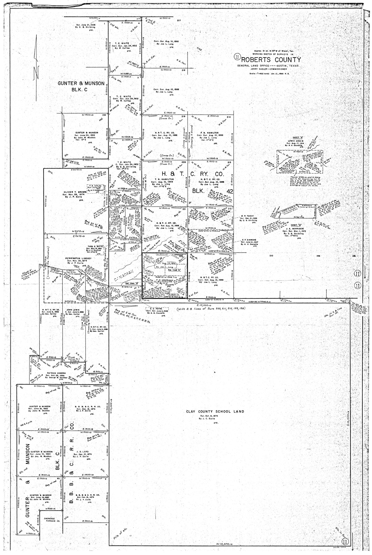
Roberts County Working Sketch 11
-
Map/Doc
63537
-
Collection
General Map Collection
-
Object Dates
1/21/1966 (Creation Date)
-
People and Organizations
Roy Buckholts (Draftsman)
-
Counties
Roberts
-
Subjects
Surveying Working Sketch
-
Height x Width
57.6 x 38.6 inches
146.3 x 98.0 cm
-
Scale
1" = 400 varas
Part of: General Map Collection
Map of Wichita County Young Land District, formerly Fannin Land District

Print $20.00
- Digital $50.00
Map of Wichita County Young Land District, formerly Fannin Land District
1859
Size 22.4 x 20.5 inches
Map/Doc 4141
Pecos County Rolled Sketch 145

Print $20.00
- Digital $50.00
Pecos County Rolled Sketch 145
1957
Size 37.2 x 27.6 inches
Map/Doc 7278
Floyd County Sketch File 22

Print $4.00
- Digital $50.00
Floyd County Sketch File 22
Size 8.8 x 8.0 inches
Map/Doc 22774
Van Zandt County Working Sketch 15

Print $20.00
- Digital $50.00
Van Zandt County Working Sketch 15
1982
Size 30.9 x 39.0 inches
Map/Doc 72265
El Paso County

Print $40.00
- Digital $50.00
El Paso County
1881
Size 53.7 x 88.3 inches
Map/Doc 16826
Leon County Working Sketch 51

Print $40.00
- Digital $50.00
Leon County Working Sketch 51
1982
Size 31.5 x 54.6 inches
Map/Doc 70450
Kendall County Sketch File 27

Print $6.00
- Digital $50.00
Kendall County Sketch File 27
1950
Size 12.4 x 10.9 inches
Map/Doc 28731
Kinney County Sketch File A1

Print $38.00
- Digital $50.00
Kinney County Sketch File A1
1905
Size 35.4 x 27.6 inches
Map/Doc 11952
Sutton County Working Sketch 25

Print $40.00
- Digital $50.00
Sutton County Working Sketch 25
Size 69.4 x 37.1 inches
Map/Doc 62368
Map of Jackson County

Print $20.00
- Digital $50.00
Map of Jackson County
1865
Size 22.2 x 19.9 inches
Map/Doc 3709
Bee County Boundary File 8

Print $52.00
- Digital $50.00
Bee County Boundary File 8
Size 9.2 x 7.8 inches
Map/Doc 50464
Map of Port Bolivar

Print $20.00
- Digital $50.00
Map of Port Bolivar
1893
Size 24.9 x 18.5 inches
Map/Doc 2191
You may also like
Map of Africa designed to accompany Smith's Geography for Schools

Print $20.00
- Digital $50.00
Map of Africa designed to accompany Smith's Geography for Schools
1850
Size 9.7 x 12.0 inches
Map/Doc 93897
Flight Mission No. BQR-9K, Frame 49, Brazoria County

Print $20.00
- Digital $50.00
Flight Mission No. BQR-9K, Frame 49, Brazoria County
1952
Size 18.6 x 22.3 inches
Map/Doc 84053
Map of XIT Lands, vicinity of Farwell, Texas

Print $20.00
- Digital $50.00
Map of XIT Lands, vicinity of Farwell, Texas
Size 19.6 x 30.8 inches
Map/Doc 91654
[Sketch of Block A1 in Hartley County]
![90762, [Sketch of Block A1 in Hartley County], Twichell Survey Records](https://historictexasmaps.com/wmedia_w700/maps/90762-1.tif.jpg)
Print $20.00
- Digital $50.00
[Sketch of Block A1 in Hartley County]
1902
Size 11.3 x 21.4 inches
Map/Doc 90762
Freestone County Working Sketch 15

Print $40.00
- Digital $50.00
Freestone County Working Sketch 15
1980
Size 56.5 x 33.7 inches
Map/Doc 69257
Flight Mission No. DCL-7C, Frame 72, Kenedy County

Print $20.00
- Digital $50.00
Flight Mission No. DCL-7C, Frame 72, Kenedy County
1943
Size 15.4 x 15.1 inches
Map/Doc 86058
Flight Mission No. DIX-6P, Frame 191, Aransas County

Print $20.00
- Digital $50.00
Flight Mission No. DIX-6P, Frame 191, Aransas County
1956
Size 19.0 x 22.7 inches
Map/Doc 83853
Val Verde County Sketch File 51c

Print $6.00
- Digital $50.00
Val Verde County Sketch File 51c
1959
Size 10.9 x 16.9 inches
Map/Doc 39332
Atascosa County Sketch File 20

Print $4.00
- Digital $50.00
Atascosa County Sketch File 20
Size 7.9 x 9.0 inches
Map/Doc 13787
Matagorda County Working Sketch 1

Print $20.00
- Digital $50.00
Matagorda County Working Sketch 1
Size 24.1 x 17.1 inches
Map/Doc 70859
Flight Mission No. DQN-2K, Frame 99, Calhoun County

Print $20.00
- Digital $50.00
Flight Mission No. DQN-2K, Frame 99, Calhoun County
1953
Size 18.7 x 22.3 inches
Map/Doc 84289
Ector County Working Sketch 24

Print $40.00
- Digital $50.00
Ector County Working Sketch 24
1961
Size 42.2 x 51.7 inches
Map/Doc 68867