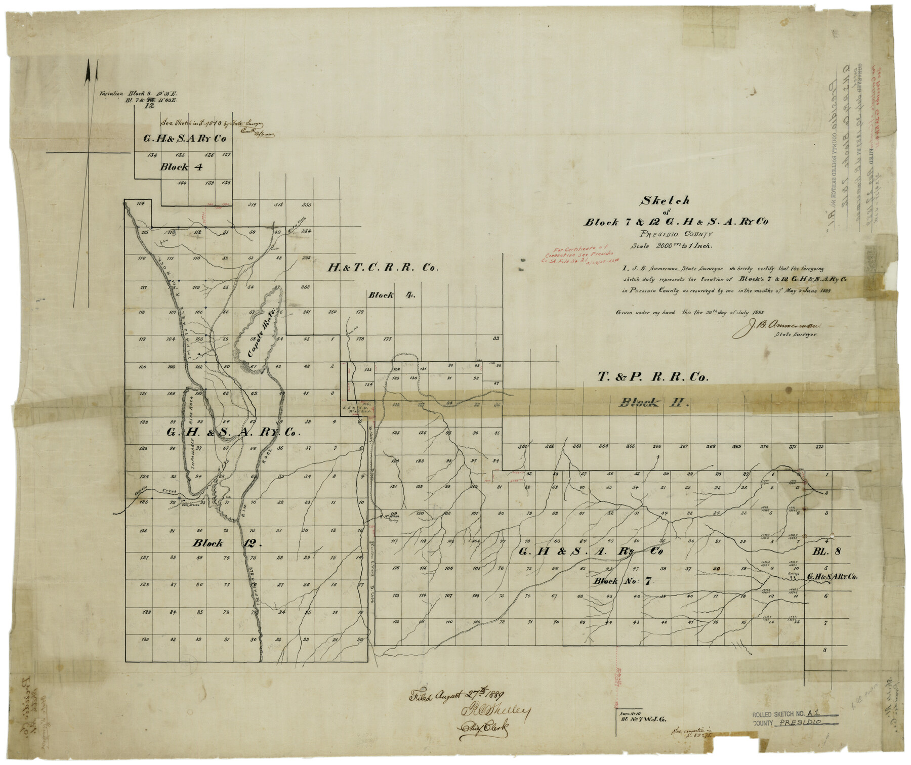
Presidio County Rolled Sketch A-1
Sketch of Block 7 & 12, G. H. & S. A. Ry. Co.
-
Map/Doc
9769
-
Collection
General Map Collection
-
Object Dates
7/30/1889 (Creation Date)
8/27/1889 (File Date)
-
People and Organizations
J.B. Ammerman (Surveyor/Engineer)
-
Counties
Presidio
-
Subjects
Surveying Rolled Sketch
-
Height x Width
26.8 x 32.0 inches
68.1 x 81.3 cm
-
Medium
linen, manuscript
-
Scale
1" = 2000 varas
-
Comments
See Presidio County Sketch File 21 (34454) for certificate of connection.
Related maps
Presidio County Sketch File 21

Print $4.00
- Digital $50.00
Presidio County Sketch File 21
1889
Size 14.2 x 8.7 inches
Map/Doc 34454
Part of: General Map Collection
Wilbarger County Working Sketch 2a

Print $20.00
- Digital $50.00
Wilbarger County Working Sketch 2a
1922
Size 19.6 x 19.8 inches
Map/Doc 72539
Lampasas County Sketch File 10

Print $8.00
- Digital $50.00
Lampasas County Sketch File 10
1872
Size 12.7 x 7.9 inches
Map/Doc 29416
Blanco County Working Sketch 20

Print $20.00
- Digital $50.00
Blanco County Working Sketch 20
1960
Size 27.3 x 36.4 inches
Map/Doc 67380
Donley County Sketch File 1

Print $6.00
- Digital $50.00
Donley County Sketch File 1
Size 8.2 x 6.5 inches
Map/Doc 21214
Red River County Working Sketch 51

Print $20.00
- Digital $50.00
Red River County Working Sketch 51
1970
Size 31.2 x 28.5 inches
Map/Doc 72034
Flight Mission No. BRA-6M, Frame 149, Jefferson County

Print $20.00
- Digital $50.00
Flight Mission No. BRA-6M, Frame 149, Jefferson County
1953
Size 18.5 x 22.3 inches
Map/Doc 85450
Kerr County Rolled Sketch 11A

Print $20.00
- Digital $50.00
Kerr County Rolled Sketch 11A
1950
Size 27.8 x 36.0 inches
Map/Doc 6496
Jim Hogg County Rolled Sketch 7

Print $20.00
- Digital $50.00
Jim Hogg County Rolled Sketch 7
1948
Size 32.5 x 28.2 inches
Map/Doc 6442
Pecos County Working Sketch 104

Print $40.00
- Digital $50.00
Pecos County Working Sketch 104
1971
Size 63.1 x 26.9 inches
Map/Doc 71577
West Houston: Hwy. 6 from Spencer Rd. in the North to South of Sugar Land. From Wilcrest Dr. in the East to and including Katy.

West Houston: Hwy. 6 from Spencer Rd. in the North to South of Sugar Land. From Wilcrest Dr. in the East to and including Katy.
Size 35.4 x 22.8 inches
Map/Doc 94335
Galveston County NRC Article 33.136 Sketch 12

Print $28.00
- Digital $50.00
Galveston County NRC Article 33.136 Sketch 12
2002
Size 22.5 x 33.8 inches
Map/Doc 66899
Presidio County Sketch File 57

Print $8.00
- Digital $50.00
Presidio County Sketch File 57
1938
Size 14.3 x 8.9 inches
Map/Doc 34624
You may also like
Caldwell County Sketch File 3

Print $4.00
- Digital $50.00
Caldwell County Sketch File 3
1872
Size 12.7 x 8.1 inches
Map/Doc 35827
Amistad International Reservoir on Rio Grande 63

Print $20.00
- Digital $50.00
Amistad International Reservoir on Rio Grande 63
1949
Size 28.2 x 39.5 inches
Map/Doc 73348
Rusk County Rolled Sketch 11

Print $20.00
- Digital $50.00
Rusk County Rolled Sketch 11
1956
Size 33.2 x 43.3 inches
Map/Doc 9877
Pecos County Rolled Sketch 126

Print $20.00
- Digital $50.00
Pecos County Rolled Sketch 126
1948
Size 42.5 x 38.4 inches
Map/Doc 9724
Trinity River, Branch Sheet/East Fork of Trinity River

Print $20.00
- Digital $50.00
Trinity River, Branch Sheet/East Fork of Trinity River
1931
Size 41.4 x 19.6 inches
Map/Doc 65240
Kimble County Sketch File 12

Print $5.00
- Digital $50.00
Kimble County Sketch File 12
Size 10.7 x 10.5 inches
Map/Doc 28935
Wilbarger County Sketch File 28

Print $20.00
- Digital $50.00
Wilbarger County Sketch File 28
2016
Size 23.9 x 36.2 inches
Map/Doc 95324
Flight Mission No. BRE-1P, Frame 140, Nueces County

Print $20.00
- Digital $50.00
Flight Mission No. BRE-1P, Frame 140, Nueces County
1956
Size 18.8 x 22.7 inches
Map/Doc 86700
Working Sketch in Stephens County

Print $20.00
- Digital $50.00
Working Sketch in Stephens County
1919
Size 11.1 x 20.6 inches
Map/Doc 91903
Jefferson County Sketch File 15b

Print $26.00
- Digital $50.00
Jefferson County Sketch File 15b
Size 17.4 x 33.2 inches
Map/Doc 11869
Webb County Sketch File 71

Print $44.00
- Digital $50.00
Webb County Sketch File 71
Size 14.4 x 7.6 inches
Map/Doc 39888
![91092, [Block M-23], Twichell Survey Records](https://historictexasmaps.com/wmedia_w700/maps/91092-1.tif.jpg)