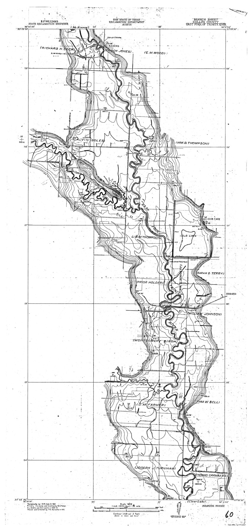
Trinity River, Branch Sheet/East Fork of Trinity River
- 
                          Map/Doc
65240
 - 
                            Collection
General Map Collection
 - 
                            Object Dates
1931 (Creation Date)
 - 
                            People and Organizations
Texas State Reclamation Department (Publisher)
Curtis R. Hale (Surveyor/Engineer)
P.E. Narvarte (Draftsman)
P.E. Narvarte (Compiler)
F.L. Mohle (Surveyor/Engineer)
B.H. Faber (Surveyor/Engineer)
S.C. Leslie (Surveyor/Engineer)
 - 
                            Counties
Collin
 - 
                            Subjects
River Surveys Topographic
 - 
                            Height x Width
41.4 x 19.6 inches
105.2 x 49.8 cm
 - 
                            Comments
Branch Sheet located suth of the McKinney Sheet and north of the Clear Lake Sheet.
 
Part of: General Map Collection
            Tarrant County Rolled Sketch 2


                                            Print $40.00                    
                                             -                         Digital $50.00                                    
                Tarrant County Rolled Sketch 2
Size 91.5 x 13.4 inches
                                Map/Doc 78246
            
            Galveston Entrance, Texas From a Trigonometrical Survey Under the direction of A.D. Bache Superintendent of the Survey of the Coast of the United States


                                            Print $20.00                    
                                             -                         Digital $50.00                                    
                Galveston Entrance, Texas From a Trigonometrical Survey Under the direction of A.D. Bache Superintendent of the Survey of the Coast of the United States
1853
Size 15.9 x 19.3 inches
                                Map/Doc 93998
            
            Montgomery County Working Sketch 12


                                            Print $20.00                    
                                             -                         Digital $50.00                                    
                Montgomery County Working Sketch 12
1933
Size 32.5 x 31.9 inches
                                Map/Doc 71119
            
            Colorado County Sketch File 17


                                            Print $22.00                    
                                             -                         Digital $50.00                                    
                Colorado County Sketch File 17
Size 8.7 x 7.7 inches
                                Map/Doc 18949
            
            Wheeler County Working Sketch 4


                                            Print $40.00                    
                                             -                         Digital $50.00                                    
                Wheeler County Working Sketch 4
1972
Size 58.9 x 47.1 inches
                                Map/Doc 72493
            
            Travis County Rolled Sketch 14


                                            Print $20.00                    
                                             -                         Digital $50.00                                    
                Travis County Rolled Sketch 14
1939
Size 30.5 x 22.3 inches
                                Map/Doc 8017
            
            Fort Bend County Sketch File 17 1/2


                                            Print $52.00                    
                                             -                         Digital $50.00                                    
                Fort Bend County Sketch File 17 1/2
1896
Size 11.2 x 8.7 inches
                                Map/Doc 22934
            
            Cass County Working Sketch 33


                                            Print $20.00                    
                                             -                         Digital $50.00                                    
                Cass County Working Sketch 33
1982
Size 27.4 x 26.6 inches
                                Map/Doc 67936
            
            Clay County Working Sketch 1


                                            Print $20.00                    
                                             -                         Digital $50.00                                    
                Clay County Working Sketch 1
Size 30.7 x 29.3 inches
                                Map/Doc 68024
            
            Traced from Genl. Arista's map captured by the American Army under Genl. Taylor at Resaca de la Palma 9th May '46 and presented to James K. Polk, President U. States


                                            Print $20.00                    
                                             -                         Digital $50.00                                    
                Traced from Genl. Arista's map captured by the American Army under Genl. Taylor at Resaca de la Palma 9th May '46 and presented to James K. Polk, President U. States
1846
Size 18.2 x 27.4 inches
                                Map/Doc 73061
            
            Rusk County Sketch File 19


                                            Print $4.00                    
                                    
                Rusk County Sketch File 19
Size 13.0 x 8.2 inches
                                Map/Doc 35526
            
            San Jacinto County Sketch File 5


                                            Print $2.00                    
                                    
                San Jacinto County Sketch File 5
1848
Size 8.1 x 14.5 inches
                                Map/Doc 35702
            You may also like
            Kinney County Working Sketch 44


                                            Print $20.00                    
                                             -                         Digital $50.00                                    
                Kinney County Working Sketch 44
1978
Size 36.7 x 25.8 inches
                                Map/Doc 70226
            
            Lampasas County


                                            Print $20.00                    
                                             -                         Digital $50.00                                    
                Lampasas County
1972
Size 34.4 x 43.4 inches
                                Map/Doc 73214
            
            Hood County Working Sketch 22


                                            Print $20.00                    
                                             -                         Digital $50.00                                    
                Hood County Working Sketch 22
1991
Size 17.9 x 27.1 inches
                                Map/Doc 66216
            
            Johnson County Boundary File 51b


                                            Print $80.00                    
                                             -                         Digital $50.00                                    
                Johnson County Boundary File 51b
Size 53.9 x 9.4 inches
                                Map/Doc 55619
            
            Sylvan Sander's Map of Lubbock, Hockley, and Cochran Counties, Texas


                                            Print $20.00                    
                                             -                         Digital $50.00                                    
                Sylvan Sander's Map of Lubbock, Hockley, and Cochran Counties, Texas
1925
Size 43.6 x 21.8 inches
                                Map/Doc 92611
            
            Newton County Sketch File 47


                                            Print $20.00                    
                                             -                         Digital $50.00                                    
                Newton County Sketch File 47
1932
Size 18.9 x 21.9 inches
                                Map/Doc 42159
            
            Flight Mission No. BRA-8M, Frame 77, Jefferson County


                                            Print $20.00                    
                                             -                         Digital $50.00                                    
                Flight Mission No. BRA-8M, Frame 77, Jefferson County
1953
Size 15.9 x 15.7 inches
                                Map/Doc 85597
            
            Dickens County Sketch File 29


                                            Print $6.00                    
                                             -                         Digital $50.00                                    
                Dickens County Sketch File 29
1921
Size 5.9 x 8.8 inches
                                Map/Doc 21016
            
            Calhoun County Rolled Sketch 13


                                            Print $20.00                    
                                             -                         Digital $50.00                                    
                Calhoun County Rolled Sketch 13
1948
Size 43.0 x 41.0 inches
                                Map/Doc 8547
            
            The Star of Llano County


                                            Price $20.00                    
                                    
                The Star of Llano County
2023
Size 3.3 x 2.8 inches
                                Map/Doc 97175
            
            Leon County Working Sketch 3


                                            Print $20.00                    
                                             -                         Digital $50.00                                    
                Leon County Working Sketch 3
1920
Size 15.9 x 14.4 inches
                                Map/Doc 70402
            
            Wheeler County Working Sketch 17


                                            Print $20.00                    
                                             -                         Digital $50.00                                    
                Wheeler County Working Sketch 17
1982
Size 33.5 x 27.7 inches
                                Map/Doc 72506