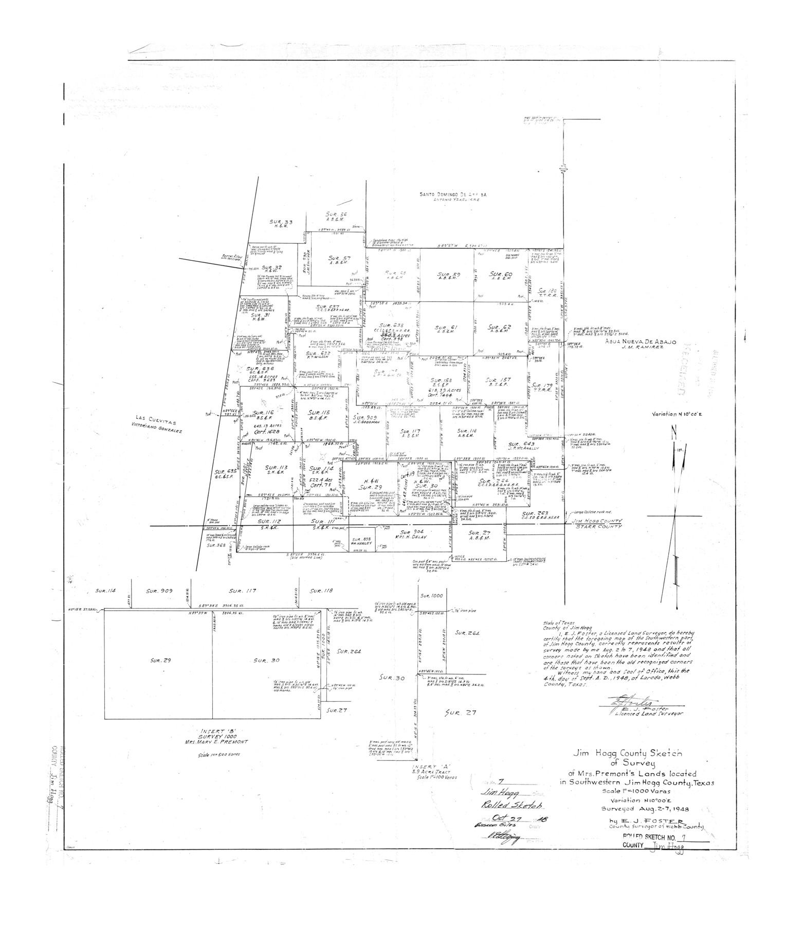
Jim Hogg County Rolled Sketch 7
Jim Hogg County sketch of survey of Mrs. Premont's lands located in southwestern Jim Hogg County, Texas
-
Map/Doc
6442
-
Collection
General Map Collection
-
Object Dates
1948/8/7 (Survey Date)
1948/10/27 (File Date)
1948/9/4 (Creation Date)
-
People and Organizations
E.J. Foster (Surveyor/Engineer)
-
Counties
Jim Hogg Starr
-
Subjects
Surveying Rolled Sketch
-
Height x Width
32.5 x 28.2 inches
82.6 x 71.6 cm
-
Scale
1" = 1000 varas
Part of: General Map Collection
A Pocket Guide to Austin, Texas - Area Map and Downtown Map

A Pocket Guide to Austin, Texas - Area Map and Downtown Map
Size 17.2 x 20.2 inches
Map/Doc 94386
Coke County Boundary File 6

Print $62.00
- Digital $50.00
Coke County Boundary File 6
Size 7.2 x 37.9 inches
Map/Doc 51615
Hockley County Sketch File M

Print $20.00
- Digital $50.00
Hockley County Sketch File M
Size 22.2 x 25.8 inches
Map/Doc 11777
Flight Mission No. CUG-3P, Frame 137, Kleberg County

Print $20.00
- Digital $50.00
Flight Mission No. CUG-3P, Frame 137, Kleberg County
1956
Size 18.4 x 22.2 inches
Map/Doc 86272

Flight Mission No. DQN-2K, Frame 44, Calhoun County

Print $20.00
- Digital $50.00
Flight Mission No. DQN-2K, Frame 44, Calhoun County
1953
Size 18.4 x 22.1 inches
Map/Doc 84249
Brewster County Rolled Sketch 42

Print $20.00
- Digital $50.00
Brewster County Rolled Sketch 42
1912
Size 18.5 x 43.3 inches
Map/Doc 5220
Cass County Rolled Sketch OPD

Print $20.00
- Digital $50.00
Cass County Rolled Sketch OPD
1936
Size 29.6 x 24.9 inches
Map/Doc 5415
Galveston County Sketch File 12

Print $6.00
- Digital $50.00
Galveston County Sketch File 12
1886
Size 15.7 x 11.4 inches
Map/Doc 23380
Map of Darrington State Farm, Brazoria County, Texas

Print $20.00
- Digital $50.00
Map of Darrington State Farm, Brazoria County, Texas
Size 18.5 x 37.9 inches
Map/Doc 62985
Van Zandt County Working Sketch 18

Print $20.00
- Digital $50.00
Van Zandt County Working Sketch 18
Size 12.5 x 18.2 inches
Map/Doc 72268
Jeff Davis County Sketch File 36

Print $40.00
- Digital $50.00
Jeff Davis County Sketch File 36
1951
Size 17.1 x 14.3 inches
Map/Doc 28048
You may also like
South Part of Webb County

Print $40.00
- Digital $50.00
South Part of Webb County
1984
Size 43.5 x 63.9 inches
Map/Doc 73320
[Randall County]
![92970, [Randall County], Twichell Survey Records](https://historictexasmaps.com/wmedia_w700/maps/92970-1.tif.jpg)
Print $20.00
- Digital $50.00
[Randall County]
Size 14.7 x 12.0 inches
Map/Doc 92970
Kinney County Working Sketch 59

Print $20.00
- Digital $50.00
Kinney County Working Sketch 59
1999
Size 19.9 x 24.8 inches
Map/Doc 70241
Sketch of coast of Texas, Laguna Madre from Pt. of Rocks to Corpus Christi [and accompanying letter]
![72964, Sketch of coast of Texas, Laguna Madre from Pt. of Rocks to Corpus Christi [and accompanying letter], General Map Collection](https://historictexasmaps.com/wmedia_w700/maps/72964.tif.jpg)
Print $2.00
- Digital $50.00
Sketch of coast of Texas, Laguna Madre from Pt. of Rocks to Corpus Christi [and accompanying letter]
Size 11.2 x 8.8 inches
Map/Doc 72964
Crockett County Rolled Sketch 76

Print $20.00
- Digital $50.00
Crockett County Rolled Sketch 76
1950
Size 24.6 x 26.1 inches
Map/Doc 5617
Goliad County Sketch File 21

Print $10.00
- Digital $50.00
Goliad County Sketch File 21
1855
Size 12.0 x 7.9 inches
Map/Doc 24284
Knox County Sketch File 11

Print $20.00
- Digital $50.00
Knox County Sketch File 11
1892
Size 26.8 x 21.9 inches
Map/Doc 11959
Orange County Sketch File 23

Print $36.00
- Digital $50.00
Orange County Sketch File 23
1911
Size 9.2 x 5.9 inches
Map/Doc 33344
Gulf of Mexico

Print $20.00
- Digital $50.00
Gulf of Mexico
1905
Size 18.3 x 26.8 inches
Map/Doc 72653
Wichita County Rolled Sketch 2

Print $20.00
- Digital $50.00
Wichita County Rolled Sketch 2
1879
Size 20.6 x 26.3 inches
Map/Doc 78471
Kimble County Rolled Sketch 41

Print $40.00
- Digital $50.00
Kimble County Rolled Sketch 41
1994
Size 38.0 x 48.9 inches
Map/Doc 9340
Wilson County Working Sketch 11

Print $20.00
- Digital $50.00
Wilson County Working Sketch 11
1980
Size 14.4 x 13.1 inches
Map/Doc 72591