Presidio County Sketch File 21
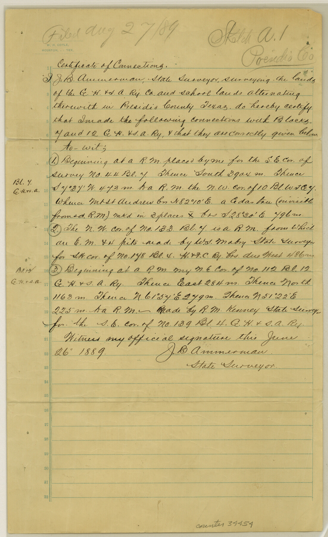
[Certificate of connections in Blocks 7 and 12, G. H. & S. A. Ry. Co.]
-
Map/Doc
34454
-
Collection
General Map Collection
-
Object Dates
8/27/1889 (File Date)
6/26/1889 (Creation Date)
-
People and Organizations
J.B. Ammerman (Surveyor/Engineer)
W.S. Mabry (Surveyor/Engineer)
R.M. Kenney (Surveyor/Engineer)
-
Counties
Presidio
-
Subjects
Surveying Sketch File
-
Height x Width
14.2 x 8.7 inches
36.1 x 22.1 cm
-
Medium
paper, manuscript
-
Comments
See Presidio County Rolled Sketch A-1 (9769) for sketch.
Related maps
Presidio County Rolled Sketch A-1

Print $20.00
- Digital $50.00
Presidio County Rolled Sketch A-1
1889
Size 26.8 x 32.0 inches
Map/Doc 9769
Part of: General Map Collection
Montgomery County Working Sketch 3

Print $20.00
- Digital $50.00
Montgomery County Working Sketch 3
1918
Size 16.5 x 14.1 inches
Map/Doc 71109
Burleson County Working Sketch 39

Print $20.00
- Digital $50.00
Burleson County Working Sketch 39
1985
Size 15.3 x 18.7 inches
Map/Doc 67758
Schleicher County Sketch File 5

Print $40.00
- Digital $50.00
Schleicher County Sketch File 5
Size 17.2 x 13.4 inches
Map/Doc 36470
Brooks County Boundary File 2

Print $8.00
- Digital $50.00
Brooks County Boundary File 2
Size 8.6 x 11.3 inches
Map/Doc 50839
Kinney County Working Sketch 44

Print $20.00
- Digital $50.00
Kinney County Working Sketch 44
1978
Size 36.7 x 25.8 inches
Map/Doc 70226
Flight Mission No. DAG-24K, Frame 146, Matagorda County

Print $20.00
- Digital $50.00
Flight Mission No. DAG-24K, Frame 146, Matagorda County
1953
Size 18.6 x 22.2 inches
Map/Doc 86560
Callahan County Working Sketch 12

Print $20.00
- Digital $50.00
Callahan County Working Sketch 12
1969
Size 25.6 x 38.5 inches
Map/Doc 67894
Donley County Working Sketch Graphic Index

Print $20.00
- Digital $50.00
Donley County Working Sketch Graphic Index
1944
Size 44.6 x 39.0 inches
Map/Doc 76526
Flight Mission No. DCL-5C, Frame 68, Kenedy County

Print $20.00
- Digital $50.00
Flight Mission No. DCL-5C, Frame 68, Kenedy County
1943
Size 18.6 x 22.4 inches
Map/Doc 85851
Nueces River, Clarkwood Sheet

Print $6.00
- Digital $50.00
Nueces River, Clarkwood Sheet
1942
Size 26.9 x 36.5 inches
Map/Doc 65099
Galveston County Rolled Sketch Z61

Print $20.00
- Digital $50.00
Galveston County Rolled Sketch Z61
1934
Size 34.9 x 23.0 inches
Map/Doc 5993
Sutton County Boundary File 1

Print $4.00
- Digital $50.00
Sutton County Boundary File 1
Size 14.5 x 8.9 inches
Map/Doc 59002
You may also like
Kaufman County, Texas

Print $20.00
- Digital $50.00
Kaufman County, Texas
1871
Size 24.9 x 18.8 inches
Map/Doc 735
Rusk County Sketch File 12

Print $6.00
- Digital $50.00
Rusk County Sketch File 12
1845
Size 8.4 x 7.9 inches
Map/Doc 35511
Angelina County Sketch File 15

Print $8.00
- Digital $50.00
Angelina County Sketch File 15
1848
Size 12.5 x 7.5 inches
Map/Doc 12960

Burnet County Sketch File 21

Print $4.00
- Digital $50.00
Burnet County Sketch File 21
Size 8.4 x 6.6 inches
Map/Doc 16714
General Highway Map, Cottle County, Texas

Print $20.00
General Highway Map, Cottle County, Texas
1961
Size 18.1 x 24.6 inches
Map/Doc 79423
Castro County, Texas

Print $20.00
- Digital $50.00
Castro County, Texas
1891
Size 24.5 x 20.4 inches
Map/Doc 694
Map of Texas, compiled from surveys on record in the General Land Office of the Republic
Print $20.00
- Digital $50.00
Map of Texas, compiled from surveys on record in the General Land Office of the Republic
1839
Size 33.0 x 25.3 inches
Map/Doc 93858
Harris County Working Sketch Graphic Index, Sheet 2 (Sketches 69 to Most Recent)

Print $20.00
- Digital $50.00
Harris County Working Sketch Graphic Index, Sheet 2 (Sketches 69 to Most Recent)
1940
Size 38.5 x 46.2 inches
Map/Doc 76569
Culberson County

Print $40.00
- Digital $50.00
Culberson County
1924
Size 32.4 x 48.5 inches
Map/Doc 92559
Wavell Empresario Colony. Proposed, March 9, 1826

Print $20.00
Wavell Empresario Colony. Proposed, March 9, 1826
2020
Size 16.0 x 21.7 inches
Map/Doc 96009
Real County Working Sketch 16

Print $20.00
- Digital $50.00
Real County Working Sketch 16
1941
Size 28.2 x 40.1 inches
Map/Doc 71908