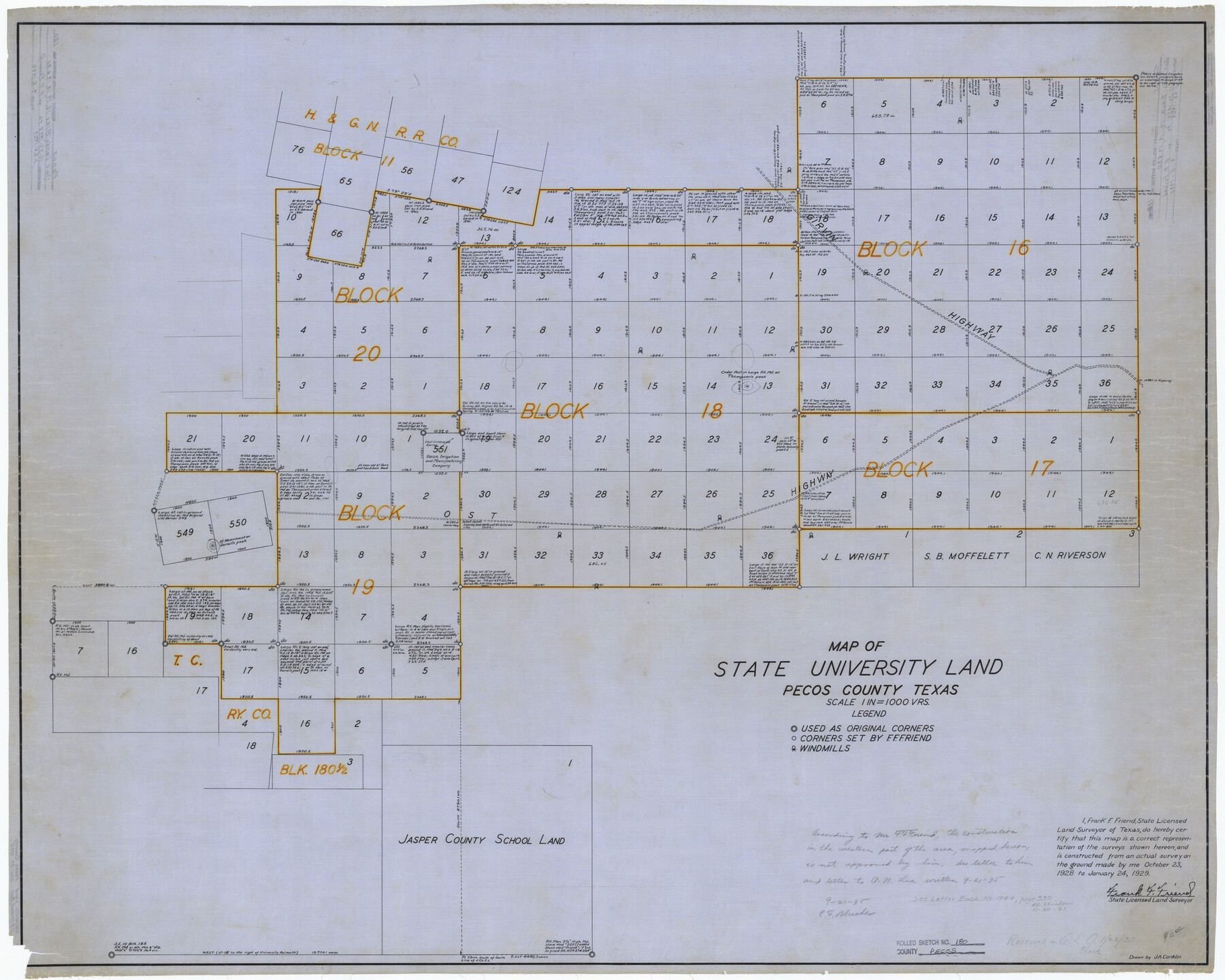
Pecos County Rolled Sketch 180
Map of State University Land, Pecos County, Texas
-
Map/Doc
9752
-
Collection
General Map Collection
-
Object Dates
1929/1/24 (Survey Date)
1980/9/5 (File Date)
-
People and Organizations
Frank F. Friend (Surveyor/Engineer)
J.A. Conklin (Draftsman)
-
Counties
Pecos
-
Subjects
Surveying Rolled Sketch
-
Height x Width
33.6 x 42.0 inches
85.3 x 106.7 cm
-
Medium
linen, manuscript
-
Scale
1" = 1000 varas
Part of: General Map Collection
"The Texas and Pacific Railway Company Reservation and Land Grant"

Print $38.00
- Digital $50.00
"The Texas and Pacific Railway Company Reservation and Land Grant"
1962
Size 9.3 x 6.5 inches
Map/Doc 62213
[Surveys near the Neches River]
![8, [Surveys near the Neches River], General Map Collection](https://historictexasmaps.com/wmedia_w700/maps/8.tif.jpg)
Print $3.00
- Digital $50.00
[Surveys near the Neches River]
Size 17.2 x 10.3 inches
Map/Doc 8
[John Schrier's league]
![286, [John Schrier's league], General Map Collection](https://historictexasmaps.com/wmedia_w700/maps/286.tif.jpg)
Print $2.00
- Digital $50.00
[John Schrier's league]
1847
Size 7.2 x 8.6 inches
Map/Doc 286
[Nueces Bay, Mustang Island and Padre Island]
![73465, [Nueces Bay, Mustang Island and Padre Island], General Map Collection](https://historictexasmaps.com/wmedia_w700/maps/73465.tif.jpg)
Print $4.00
- Digital $50.00
[Nueces Bay, Mustang Island and Padre Island]
Size 18.1 x 24.7 inches
Map/Doc 73465
Pecos County Rolled Sketch 117

Print $40.00
- Digital $50.00
Pecos County Rolled Sketch 117
1944
Size 44.6 x 52.6 inches
Map/Doc 9722
Burleson County Sketch File 5

Print $4.00
- Digital $50.00
Burleson County Sketch File 5
Size 12.9 x 8.3 inches
Map/Doc 16649
Tom Green County Working Sketch 8

Print $20.00
- Digital $50.00
Tom Green County Working Sketch 8
1950
Size 24.8 x 20.9 inches
Map/Doc 69377
El Paso County Working Sketch 25

Print $20.00
- Digital $50.00
El Paso County Working Sketch 25
1962
Size 42.7 x 41.9 inches
Map/Doc 69047
Mitchell County Sketch File 7

Print $20.00
- Digital $50.00
Mitchell County Sketch File 7
1906
Size 19.4 x 12.4 inches
Map/Doc 12096
Maps of Gulf Intracoastal Waterway, Texas - Sabine River to the Rio Grande and connecting waterways including ship channels

Print $20.00
- Digital $50.00
Maps of Gulf Intracoastal Waterway, Texas - Sabine River to the Rio Grande and connecting waterways including ship channels
1966
Size 14.5 x 22.2 inches
Map/Doc 61941
Travis County State Real Property Sketch 9

Print $20.00
- Digital $50.00
Travis County State Real Property Sketch 9
2002
Size 30.6 x 42.5 inches
Map/Doc 82560
Eastland County Working Sketch 47

Print $20.00
- Digital $50.00
Eastland County Working Sketch 47
1981
Size 30.0 x 27.1 inches
Map/Doc 68828
You may also like
Bee County Sketch File 8a

Print $8.00
- Digital $50.00
Bee County Sketch File 8a
1874
Size 6.0 x 7.6 inches
Map/Doc 14283
Terrell County

Print $20.00
- Digital $50.00
Terrell County
1905
Size 40.5 x 32.3 inches
Map/Doc 4075
Maps of Gulf Intracoastal Waterway, Texas - Sabine River to the Rio Grande and connecting waterways including ship channels

Print $20.00
- Digital $50.00
Maps of Gulf Intracoastal Waterway, Texas - Sabine River to the Rio Grande and connecting waterways including ship channels
1966
Size 14.6 x 21.6 inches
Map/Doc 61982
Refugio County Sketch File 10

Print $4.00
- Digital $50.00
Refugio County Sketch File 10
Size 8.2 x 9.4 inches
Map/Doc 35258
Flight Mission No. DCL-4C, Frame 123, Kenedy County

Print $20.00
- Digital $50.00
Flight Mission No. DCL-4C, Frame 123, Kenedy County
1943
Size 18.6 x 22.3 inches
Map/Doc 85822
G. W. Cochran Farm Section 32, Block JS

Print $20.00
- Digital $50.00
G. W. Cochran Farm Section 32, Block JS
1943
Size 12.6 x 23.4 inches
Map/Doc 92328
Flight Mission No. DIX-5P, Frame 142, Aransas County

Print $20.00
- Digital $50.00
Flight Mission No. DIX-5P, Frame 142, Aransas County
1956
Size 18.0 x 18.0 inches
Map/Doc 83803
Parker County Sketch File 38

Print $20.00
- Digital $50.00
Parker County Sketch File 38
Size 21.7 x 13.3 inches
Map/Doc 12149
Map of Glasscock County

Print $20.00
- Digital $50.00
Map of Glasscock County
Size 18.9 x 23.2 inches
Map/Doc 90711
Interfaith's Official Map: The Woodlands, a real hometown for people and companies

Interfaith's Official Map: The Woodlands, a real hometown for people and companies
1997
Size 36.7 x 22.5 inches
Map/Doc 94285
General Highway Map, Bosque County, Texas

Print $20.00
General Highway Map, Bosque County, Texas
1961
Size 24.7 x 18.1 inches
Map/Doc 79378
Frio County Rolled Sketch 28

Print $20.00
- Digital $50.00
Frio County Rolled Sketch 28
2014
Size 36.3 x 24.7 inches
Map/Doc 97420