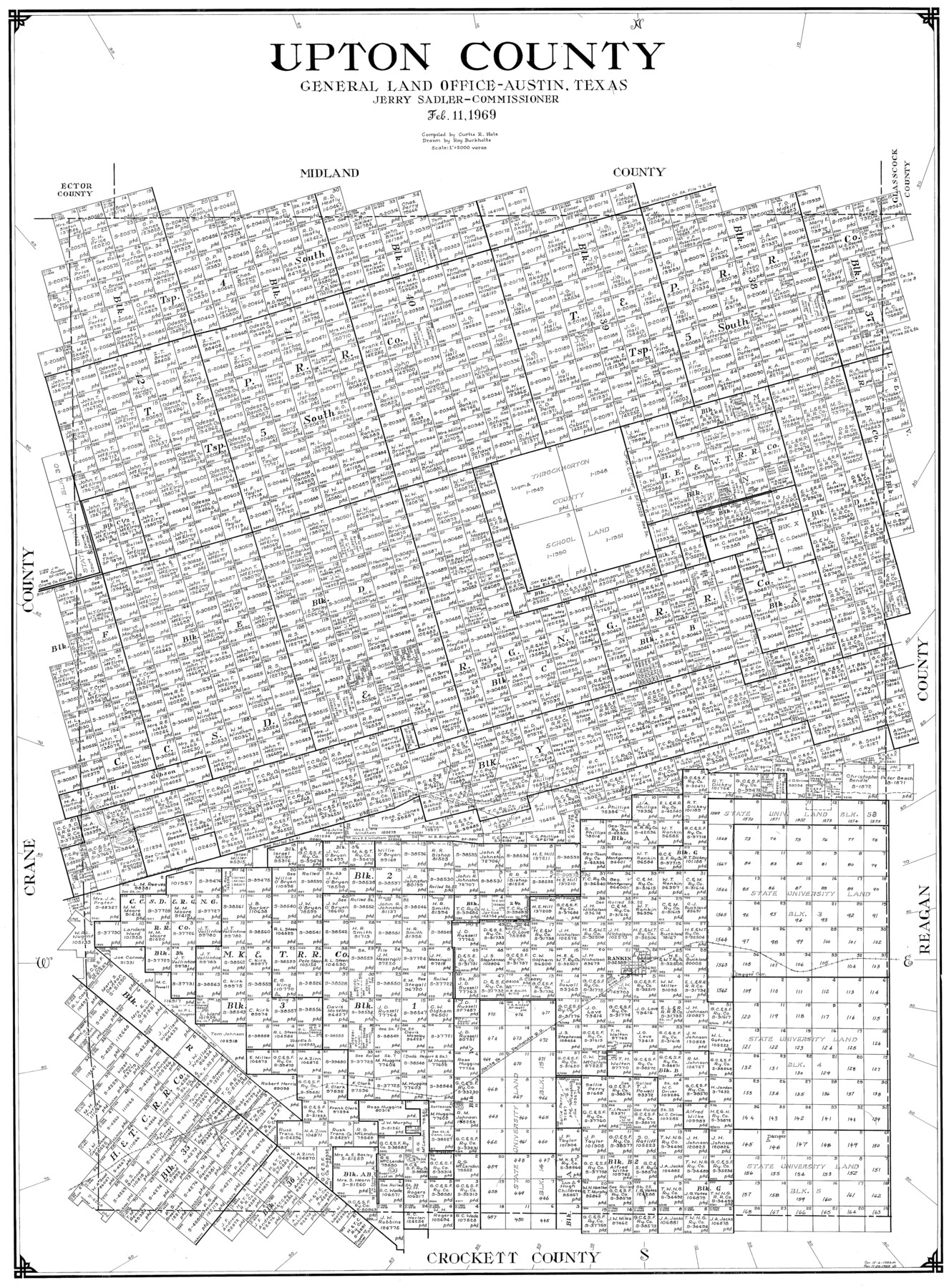
Upton County
-
Map/Doc
77443
-
Collection
General Map Collection
-
Object Dates
1969/2/11 (Creation Date)
-
People and Organizations
Curtis R. Hale (Compiler)
Roy Buckholts (Draftsman)
-
Counties
Upton
-
Subjects
County
-
Height x Width
40.5 x 29.9 inches
102.9 x 76.0 cm
Part of: General Map Collection
Mosaic composed of aerial photographs - Houston Ship Channel, Tex.

Print $20.00
- Digital $50.00
Mosaic composed of aerial photographs - Houston Ship Channel, Tex.
1923
Size 13.7 x 38.0 inches
Map/Doc 97172
Wharton County Sketch File 6

Print $4.00
- Digital $50.00
Wharton County Sketch File 6
1877
Size 8.6 x 14.2 inches
Map/Doc 39923
Lee County Working Sketch 10

Print $20.00
- Digital $50.00
Lee County Working Sketch 10
1979
Size 32.6 x 35.4 inches
Map/Doc 70389

Flight Mission No. CUG-1P, Frame 159, Kleberg County

Print $20.00
- Digital $50.00
Flight Mission No. CUG-1P, Frame 159, Kleberg County
1956
Size 18.5 x 22.3 inches
Map/Doc 86166
Rusk County Working Sketch 29a

Print $20.00
- Digital $50.00
Rusk County Working Sketch 29a
1933
Size 18.1 x 25.8 inches
Map/Doc 63665
Duval County Working Sketch 57

Print $20.00
- Digital $50.00
Duval County Working Sketch 57
1990
Size 30.3 x 25.4 inches
Map/Doc 68781
[Surveys on the Trinity River]
![342, [Surveys on the Trinity River], General Map Collection](https://historictexasmaps.com/wmedia_w700/maps/342.tif.jpg)
Print $2.00
- Digital $50.00
[Surveys on the Trinity River]
Size 6.6 x 4.6 inches
Map/Doc 342
Crockett County Working Sketch 53

Print $20.00
- Digital $50.00
Crockett County Working Sketch 53
1948
Size 24.2 x 27.7 inches
Map/Doc 68386
Dawson County Sketch File 31

Print $4.00
- Digital $50.00
Dawson County Sketch File 31
1989
Size 11.4 x 9.0 inches
Map/Doc 20614
Jesse Devore League

Print $20.00
- Digital $50.00
Jesse Devore League
1919
Size 45.6 x 37.4 inches
Map/Doc 65460
[Sketch for Mineral Application 26501 - Sabine River, T. A. Oldhausen]
![2846, [Sketch for Mineral Application 26501 - Sabine River, T. A. Oldhausen], General Map Collection](https://historictexasmaps.com/wmedia_w700/maps/2846.tif.jpg)
Print $20.00
- Digital $50.00
[Sketch for Mineral Application 26501 - Sabine River, T. A. Oldhausen]
1931
Size 24.4 x 37.0 inches
Map/Doc 2846
You may also like
Cottle County Working Sketch 17

Print $20.00
- Digital $50.00
Cottle County Working Sketch 17
1975
Size 32.5 x 34.1 inches
Map/Doc 68327
Map of the Southern Pacific and connecting lines

Print $20.00
- Digital $50.00
Map of the Southern Pacific and connecting lines
1897
Size 8.7 x 15.9 inches
Map/Doc 95763
Map of Runnels Co[unty]
![88991, Map of Runnels Co[unty], Library of Congress](https://historictexasmaps.com/wmedia_w700/maps/88991.tif.jpg)
Print $20.00
Map of Runnels Co[unty]
1879
Size 24.5 x 18.2 inches
Map/Doc 88991
Hardin County Sketch File 59

Print $6.00
- Digital $50.00
Hardin County Sketch File 59
Size 16.8 x 11.6 inches
Map/Doc 25233
Flight Mission No. DCL-7C, Frame 71, Kenedy County

Print $20.00
- Digital $50.00
Flight Mission No. DCL-7C, Frame 71, Kenedy County
1943
Size 15.5 x 15.1 inches
Map/Doc 86057
East Part of Jeff Davis Co.

Print $20.00
- Digital $50.00
East Part of Jeff Davis Co.
1977
Size 47.9 x 36.9 inches
Map/Doc 95544
Aransas County Rolled Sketch 21

Print $20.00
- Digital $50.00
Aransas County Rolled Sketch 21
Size 43.0 x 43.8 inches
Map/Doc 8415
Upton County Rolled Sketch 43

Print $40.00
- Digital $50.00
Upton County Rolled Sketch 43
Size 27.1 x 54.2 inches
Map/Doc 10057
Lee County Sketch File 9

Print $4.00
- Digital $50.00
Lee County Sketch File 9
Size 8.8 x 8.2 inches
Map/Doc 29709
Rio Grande - Fernando Sheet

Print $40.00
- Digital $50.00
Rio Grande - Fernando Sheet
1925
Size 28.8 x 66.7 inches
Map/Doc 65115
[Sections 302-313 and sections south of Blocks D and AX]
![92017, [Sections 302-313 and sections south of Blocks D and AX], Twichell Survey Records](https://historictexasmaps.com/wmedia_w700/maps/92017-1.tif.jpg)
Print $20.00
- Digital $50.00
[Sections 302-313 and sections south of Blocks D and AX]
Size 17.5 x 35.6 inches
Map/Doc 92017
Hemphill County

Print $20.00
- Digital $50.00
Hemphill County
1899
Size 43.0 x 36.4 inches
Map/Doc 4976