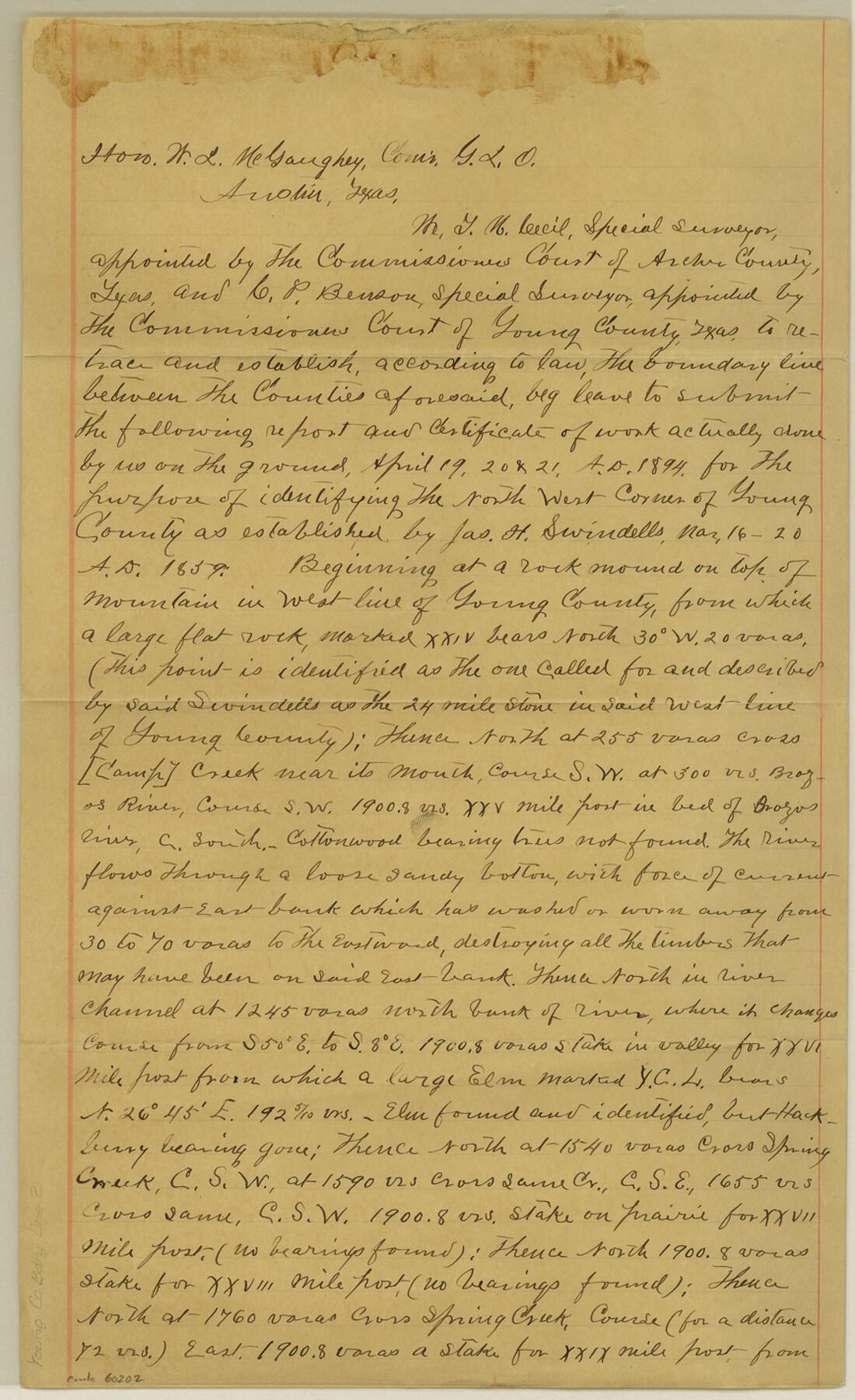
Young County Boundary File 2
N. W. Corner of Young County
-
Map/Doc
60202
-
Collection
General Map Collection
-
Counties
Young
-
Subjects
County Boundaries
-
Height x Width
14.2 x 8.7 inches
36.1 x 22.1 cm
Part of: General Map Collection
Winkler County Working Sketch 21

Print $20.00
- Digital $50.00
Winkler County Working Sketch 21
2015
Size 33.2 x 45.7 inches
Map/Doc 93728
Sutton County Sketch File 54

Print $6.00
- Digital $50.00
Sutton County Sketch File 54
1948
Size 10.8 x 11.5 inches
Map/Doc 37534
Irion County Rolled Sketch 14

Print $20.00
- Digital $50.00
Irion County Rolled Sketch 14
1946
Size 25.3 x 21.9 inches
Map/Doc 6324
Bowie County Sketch File A

Print $40.00
- Digital $50.00
Bowie County Sketch File A
1902
Size 15.6 x 27.3 inches
Map/Doc 10946
Val Verde County Working Sketch 31

Print $20.00
- Digital $50.00
Val Verde County Working Sketch 31
1938
Size 19.2 x 15.3 inches
Map/Doc 72166
Presidio County Working Sketch 30

Print $20.00
- Digital $50.00
Presidio County Working Sketch 30
1946
Size 32.3 x 40.9 inches
Map/Doc 71707
Ector County Working Sketch 4

Print $20.00
- Digital $50.00
Ector County Working Sketch 4
1940
Size 25.8 x 30.0 inches
Map/Doc 68847
Llano County Working Sketch 3

Print $20.00
- Digital $50.00
Llano County Working Sketch 3
1949
Size 23.6 x 24.0 inches
Map/Doc 70621
Flight Mission No. CUG-3P, Frame 133, Kleberg County

Print $20.00
- Digital $50.00
Flight Mission No. CUG-3P, Frame 133, Kleberg County
1956
Size 18.7 x 22.2 inches
Map/Doc 86268
Topographical Map of the Rio Grande, Sheet No. 21

Print $20.00
- Digital $50.00
Topographical Map of the Rio Grande, Sheet No. 21
1912
Map/Doc 89545
Flight Mission No. CRC-3R, Frame 164, Chambers County

Print $20.00
- Digital $50.00
Flight Mission No. CRC-3R, Frame 164, Chambers County
1956
Size 18.7 x 22.3 inches
Map/Doc 84846
Supreme Court of the United States, October Term, 1923, No. 15, Original - The State of Oklahoma, Complainant vs. The State of Texas, Defendant, The United States, Intervener; Report of the Boundary Commissioners

Print $20.00
- Digital $50.00
Supreme Court of the United States, October Term, 1923, No. 15, Original - The State of Oklahoma, Complainant vs. The State of Texas, Defendant, The United States, Intervener; Report of the Boundary Commissioners
1923
Size 25.0 x 37.8 inches
Map/Doc 75121
You may also like
McLennan County Boundary File 5

Print $64.00
- Digital $50.00
McLennan County Boundary File 5
Size 11.2 x 8.7 inches
Map/Doc 56983
Culberson County Working Sketch 23

Print $20.00
- Digital $50.00
Culberson County Working Sketch 23
1945
Size 38.3 x 44.7 inches
Map/Doc 68476
Polk County Texas

Print $20.00
- Digital $50.00
Polk County Texas
1897
Size 27.1 x 21.0 inches
Map/Doc 3956
Flight Mission No. BRA-7M, Frame 43, Jefferson County

Print $20.00
- Digital $50.00
Flight Mission No. BRA-7M, Frame 43, Jefferson County
1953
Size 18.6 x 22.4 inches
Map/Doc 85494
Floyd County Sketch File 13

Print $36.00
- Digital $50.00
Floyd County Sketch File 13
1913
Size 11.4 x 9.0 inches
Map/Doc 22713
[Cotton Belt] St. Louis Southwestern Railway of Texas, Alignment through Smith County
![64373, [Cotton Belt] St. Louis Southwestern Railway of Texas, Alignment through Smith County, General Map Collection](https://historictexasmaps.com/wmedia_w700/maps/64373.tif.jpg)
Print $20.00
- Digital $50.00
[Cotton Belt] St. Louis Southwestern Railway of Texas, Alignment through Smith County
1903
Size 21.4 x 28.4 inches
Map/Doc 64373
Nueces County Sketch File 16

Print $6.00
- Digital $50.00
Nueces County Sketch File 16
1875
Size 15.5 x 10.7 inches
Map/Doc 32547
Childress County Rolled Sketch 12

Print $20.00
- Digital $50.00
Childress County Rolled Sketch 12
1940
Size 44.2 x 11.3 inches
Map/Doc 8603
General Highway Map, Bastrop County, Texas

Print $20.00
General Highway Map, Bastrop County, Texas
1961
Size 18.3 x 24.8 inches
Map/Doc 79361
San Jacinto County Working Sketch 44

Print $20.00
- Digital $50.00
San Jacinto County Working Sketch 44
1981
Size 20.6 x 11.4 inches
Map/Doc 63758
Leon County Sketch File 9

Print $4.00
- Digital $50.00
Leon County Sketch File 9
1863
Size 15.1 x 8.3 inches
Map/Doc 29726
Kimble County Working Sketch 58

Print $20.00
- Digital $50.00
Kimble County Working Sketch 58
1959
Size 12.8 x 26.4 inches
Map/Doc 70126