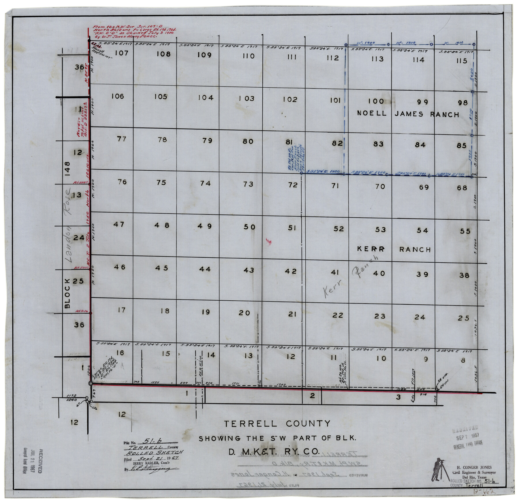
Terrell County Rolled Sketch 51B
Terrell County - showing the SW part of Blk. D, M. K. & T. Ry. Co.
-
Map/Doc
7969
-
Collection
General Map Collection
-
Object Dates
9/1957 (Creation Date)
7/21/1967 (File Date)
-
People and Organizations
H. Conger Jones (Surveyor/Engineer)
-
Counties
Terrell
-
Subjects
Surveying Rolled Sketch
-
Height x Width
23.0 x 23.8 inches
58.4 x 60.5 cm
-
Medium
linen, manuscript
Related maps
Terrell County Sketch File 35

Print $36.00
- Digital $50.00
Terrell County Sketch File 35
1957
Size 32.0 x 37.6 inches
Map/Doc 10389
Part of: General Map Collection
Pecos County Working Sketch 141

Print $20.00
- Digital $50.00
Pecos County Working Sketch 141
1941
Size 31.8 x 42.5 inches
Map/Doc 9733
Falls County Sketch File 27

Print $6.00
- Digital $50.00
Falls County Sketch File 27
Size 16.1 x 11.0 inches
Map/Doc 22436
[Surveys in Williamson County]
![78374, [Surveys in Williamson County], General Map Collection](https://historictexasmaps.com/wmedia_w700/maps/78374.tif.jpg)
Print $2.00
- Digital $50.00
[Surveys in Williamson County]
1846
Size 9.2 x 11.8 inches
Map/Doc 78374
Galveston County NRC Article 33.136 Sketch 23

Print $22.00
- Digital $50.00
Galveston County NRC Article 33.136 Sketch 23
2002
Size 11.4 x 16.4 inches
Map/Doc 81905
Hardin County Sketch File 28

Print $4.00
- Digital $50.00
Hardin County Sketch File 28
Size 5.9 x 5.8 inches
Map/Doc 25153
Madison County Working Sketch 15

Print $20.00
- Digital $50.00
Madison County Working Sketch 15
2009
Size 42.3 x 36.0 inches
Map/Doc 89019
Henderson County Boundary File 3b

Print $14.00
- Digital $50.00
Henderson County Boundary File 3b
Size 14.4 x 8.9 inches
Map/Doc 54700
La Salle County Working Sketch 9

Print $20.00
- Digital $50.00
La Salle County Working Sketch 9
1925
Size 21.2 x 15.6 inches
Map/Doc 70310
Hardeman County Sketch File A1

Print $14.00
- Digital $50.00
Hardeman County Sketch File A1
1891
Size 12.7 x 8.2 inches
Map/Doc 25045
Travis County Working Sketch 38

Print $20.00
- Digital $50.00
Travis County Working Sketch 38
1974
Size 17.5 x 34.8 inches
Map/Doc 69422
Crockett County Working Sketch 2

Print $20.00
- Digital $50.00
Crockett County Working Sketch 2
Size 18.4 x 14.9 inches
Map/Doc 68335
[Sketch for Mineral Application 26501 - Sabine River, T. A. Oldhausen]
![2841, [Sketch for Mineral Application 26501 - Sabine River, T. A. Oldhausen], General Map Collection](https://historictexasmaps.com/wmedia_w700/maps/2841.tif.jpg)
Print $20.00
- Digital $50.00
[Sketch for Mineral Application 26501 - Sabine River, T. A. Oldhausen]
1931
Size 24.4 x 36.8 inches
Map/Doc 2841
You may also like
Grayson County Sketch File 27

Print $122.00
- Digital $50.00
Grayson County Sketch File 27
1875
Size 12.8 x 8.0 inches
Map/Doc 24510
Kimble County Working Sketch 25

Print $20.00
- Digital $50.00
Kimble County Working Sketch 25
1937
Size 22.9 x 22.7 inches
Map/Doc 70093
Bexar County Working Sketch 4

Print $20.00
- Digital $50.00
Bexar County Working Sketch 4
1941
Size 19.4 x 21.7 inches
Map/Doc 67320
Map of Bastrop District

Print $20.00
- Digital $50.00
Map of Bastrop District
1847
Size 22.9 x 28.3 inches
Map/Doc 3275
Upton County Sketch File 40a

Print $40.00
- Digital $50.00
Upton County Sketch File 40a
1963
Size 11.2 x 18.3 inches
Map/Doc 38917

Walker County Working Sketch 18

Print $20.00
- Digital $50.00
Walker County Working Sketch 18
1991
Size 29.4 x 31.5 inches
Map/Doc 72298
Rand McNally Standard Map of Texas (reverse)

Print $20.00
Rand McNally Standard Map of Texas (reverse)
1923
Size 39.8 x 27.2 inches
Map/Doc 76229
Chambers County Sketch File 29

Print $20.00
- Digital $50.00
Chambers County Sketch File 29
Size 29.0 x 34.5 inches
Map/Doc 10332
Culberson County Rolled Sketch 65

Print $20.00
- Digital $50.00
Culberson County Rolled Sketch 65
1987
Size 23.7 x 18.8 inches
Map/Doc 5681
[Map of Connecting Lines along or near the Red River]
![75545, [Map of Connecting Lines along or near the Red River], General Map Collection](https://historictexasmaps.com/wmedia_w700/maps/75545.tif.jpg)
Print $40.00
- Digital $50.00
[Map of Connecting Lines along or near the Red River]
Size 37.9 x 48.7 inches
Map/Doc 75545
Harris County Sketch File 66

Print $20.00
- Digital $50.00
Harris County Sketch File 66
Size 16.9 x 27.5 inches
Map/Doc 11661