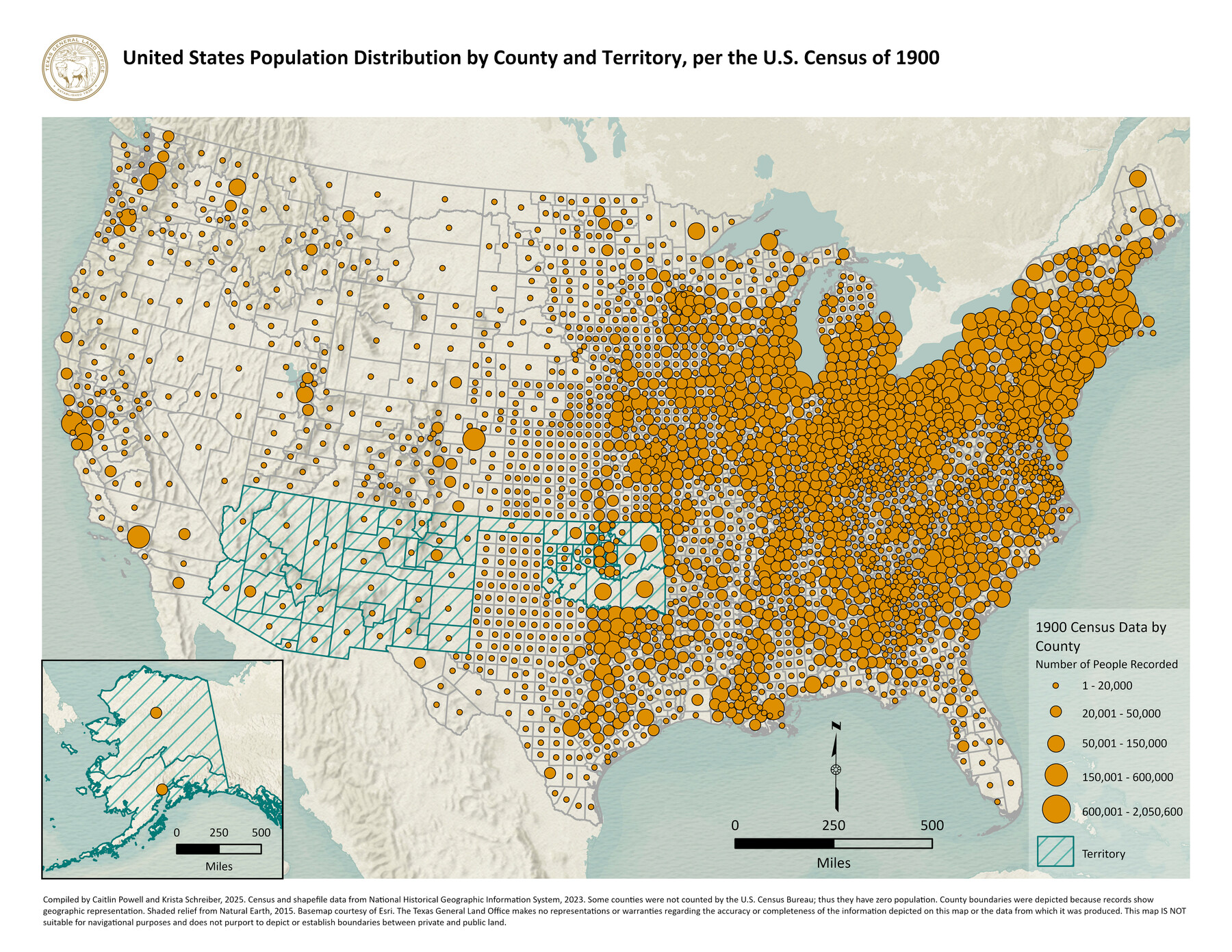
United States Population Distribution by County and Territory, per the U.S. Census of 1900
-
Map/Doc
97481
-
Collection
GIS Educational Maps
-
Object Dates
2025 (Creation Date)
-
People and Organizations
Caitlin Powell (Compiler)
Krista Schreiber (Compiler)
-
Subjects
United States Geographic Information System
-
Height x Width
8.5 x 11.0 inches
21.6 x 27.9 cm
Part of: GIS Educational Maps

North American Territorial Claims and the Treaty of Paris

North American Territorial Claims and the Treaty of Paris
2025
Size 11.0 x 17.0 inches
Map/Doc 97453
Events of the Texas Revolution

Events of the Texas Revolution
2023
Size 11.0 x 17.0 inches
Map/Doc 97194
Disputed Territory Between Mexico and the United States

Disputed Territory Between Mexico and the United States
2023
Size 11.0 x 8.5 inches
Map/Doc 97129
Yellow Fever Deaths in Texas and Louisiana

Yellow Fever Deaths in Texas and Louisiana
2022
Size 8.5 x 11.0 inches
Map/Doc 97094
United States Population Distribution by County and Territory, per the U.S. Census of 1890

United States Population Distribution by County and Territory, per the U.S. Census of 1890
2025
Size 8.5 x 11.0 inches
Map/Doc 97480
Yellow Fever Deaths in the United States

Yellow Fever Deaths in the United States
2022
Size 8.5 x 11.0 inches
Map/Doc 97093
Explorations of the Louisiana Purchase

Explorations of the Louisiana Purchase
2023
Size 8.5 x 11.0 inches
Map/Doc 97183
The Dust Bowl: Severe Drought During the Depression

The Dust Bowl: Severe Drought During the Depression
2022
Size 8.5 x 11.0 inches
Map/Doc 97095
Map Showing the Distribution of the Slave Population of the Southern States of the United States

Map Showing the Distribution of the Slave Population of the Southern States of the United States
2022
Size 8.5 x 11.0 inches
Map/Doc 96677
Events of the Texas Revolution

Events of the Texas Revolution
2023
Size 8.5 x 11.0 inches
Map/Doc 97188
The Buffalo Bayou, Brazos and Colorado Railroad (BBB&C)

The Buffalo Bayou, Brazos and Colorado Railroad (BBB&C)
2022
Size 8.5 x 11.0 inches
Map/Doc 97088
You may also like
Walker County Working Sketch 5

Print $20.00
- Digital $50.00
Walker County Working Sketch 5
1934
Size 24.5 x 30.8 inches
Map/Doc 72285
Duval County Rolled Sketch OS

Print $20.00
- Digital $50.00
Duval County Rolled Sketch OS
1903
Size 36.0 x 31.9 inches
Map/Doc 8803
[Corpus Christi Bay, Padre Island, Mustang Island, Laguna de la Madre, King and Kenedy's Pasture]
![73041, [Corpus Christi Bay, Padre Island, Mustang Island, Laguna de la Madre, King and Kenedy's Pasture], General Map Collection](https://historictexasmaps.com/wmedia_w700/maps/73041.tif.jpg)
Print $20.00
- Digital $50.00
[Corpus Christi Bay, Padre Island, Mustang Island, Laguna de la Madre, King and Kenedy's Pasture]
Size 26.2 x 18.1 inches
Map/Doc 73041
Zapata County Working Sketch 14

Print $20.00
- Digital $50.00
Zapata County Working Sketch 14
1962
Size 44.5 x 40.4 inches
Map/Doc 62065
Coast Chart No. 106 - Oyster Bay to Matagorda Bay, Texas

Print $20.00
- Digital $50.00
Coast Chart No. 106 - Oyster Bay to Matagorda Bay, Texas
1881
Size 33.5 x 40.7 inches
Map/Doc 69929
Kinney County Sketch File 11

Print $20.00
- Digital $50.00
Kinney County Sketch File 11
1885
Size 28.3 x 18.1 inches
Map/Doc 11939
United States including territories and insular possessions showing the extent of public surveys, national parks, national forests, indian reservations, national wildlife refuges, and reclamation projects

Print $40.00
- Digital $50.00
United States including territories and insular possessions showing the extent of public surveys, national parks, national forests, indian reservations, national wildlife refuges, and reclamation projects
1953
Size 64.3 x 44.5 inches
Map/Doc 65796
Howard County Sketch File 8

Print $3.00
- Digital $50.00
Howard County Sketch File 8
Size 20.8 x 18.7 inches
Map/Doc 11796
El Paso County Working Sketch 23

Print $20.00
- Digital $50.00
El Paso County Working Sketch 23
1961
Size 22.3 x 28.8 inches
Map/Doc 69045
Township 15 South Range 15 West and Fractional Township 16 South Range 15 West, South Western District, Louisiana

Print $20.00
- Digital $50.00
Township 15 South Range 15 West and Fractional Township 16 South Range 15 West, South Western District, Louisiana
1875
Size 19.6 x 24.7 inches
Map/Doc 65861
Blanco County Boundary File 8

Print $20.00
- Digital $50.00
Blanco County Boundary File 8
Size 20.1 x 11.1 inches
Map/Doc 50575
Hunt County Rolled Sketch 5

Print $20.00
- Digital $50.00
Hunt County Rolled Sketch 5
1956
Size 27.6 x 24.8 inches
Map/Doc 6270