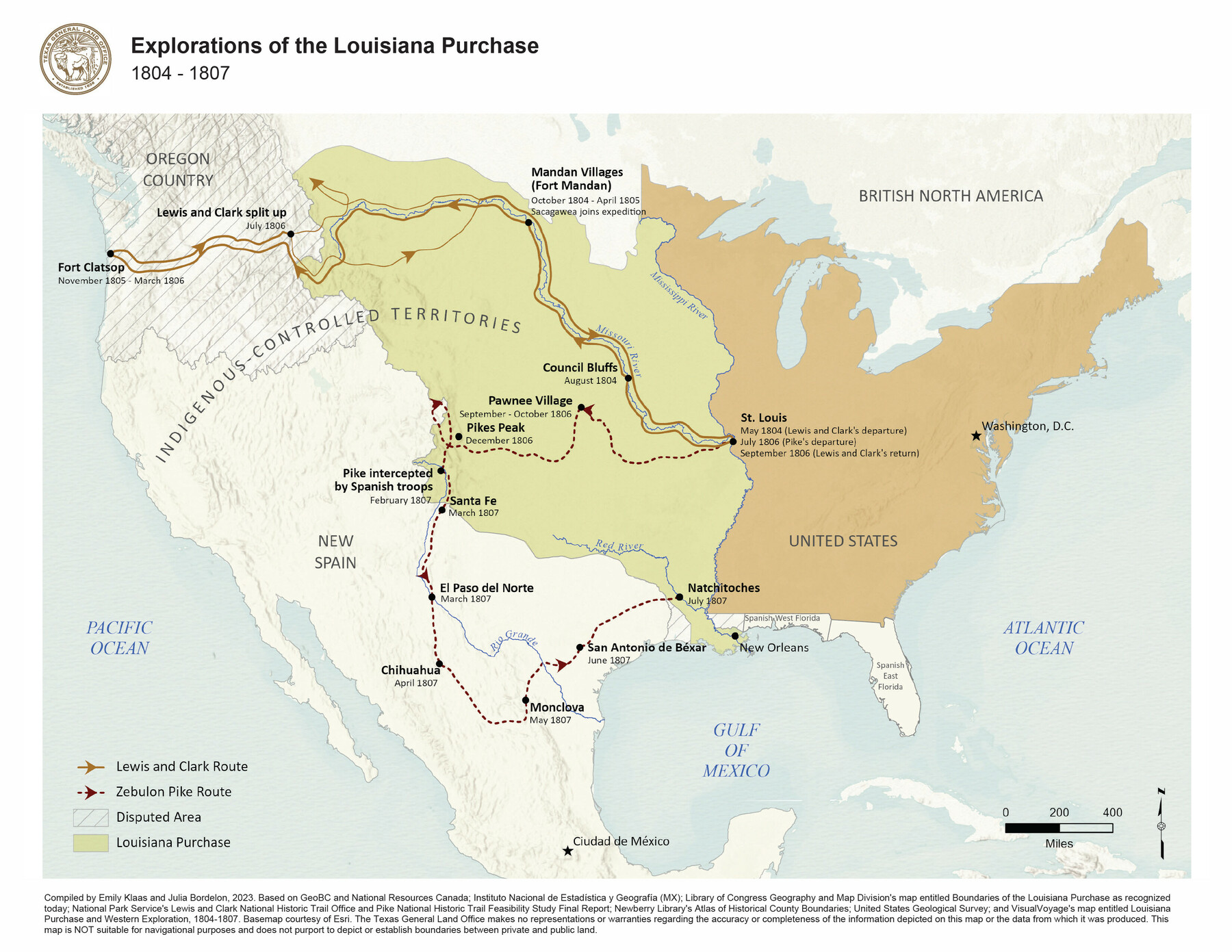
Explorations of the Louisiana Purchase
1804 - 1807
-
Map/Doc
97183
-
Collection
GIS Educational Maps
-
Object Dates
2023 (Creation Date)
-
People and Organizations
Emily Klaas (Compiler)
Julia Bordelon (Compiler)
-
Subjects
Geographic Information System United States
-
Height x Width
8.5 x 11.0 inches
21.6 x 27.9 cm
-
Medium
pdf
Related maps

Part of: GIS Educational Maps
Events of the Texas Revolution

Events of the Texas Revolution
2023
Size 8.5 x 11.0 inches
Map/Doc 97188
Events of the Texas Revolution

Events of the Texas Revolution
2023
Size 11.0 x 8.5 inches
Map/Doc 97189
Northern Mexico Campaign of the U.S. - Mexico War

Northern Mexico Campaign of the U.S. - Mexico War
2023
Size 8.5 x 11.0 inches
Map/Doc 97152
United States Population Distribution by County and Territory, per the U.S. Census of 1900

United States Population Distribution by County and Territory, per the U.S. Census of 1900
2025
Size 8.5 x 11.0 inches
Map/Doc 97481

The Buffalo Bayou, Brazos and Colorado Railroad (BBB&C)

The Buffalo Bayou, Brazos and Colorado Railroad (BBB&C)
2022
Size 8.5 x 11.0 inches
Map/Doc 97088
Big Inch and Little Big Inch Pipelines

Big Inch and Little Big Inch Pipelines
2022
Size 8.5 x 11.0 inches
Map/Doc 97089

American Civil War Political Loyalties

American Civil War Political Loyalties
2022
Size 8.5 x 11.0 inches
Map/Doc 97091
Map Showing the Distribution of the Slave Population of the Southern States of the United States

Map Showing the Distribution of the Slave Population of the Southern States of the United States
2022
Size 8.5 x 11.0 inches
Map/Doc 96677
Military Reconstruction Districts

Military Reconstruction Districts
2024
Size 8.5 x 11.0 inches
Map/Doc 97345
United States Population Distribution by County and Territory, per the U.S. Census of 1890

United States Population Distribution by County and Territory, per the U.S. Census of 1890
2025
Size 8.5 x 11.0 inches
Map/Doc 97480
You may also like
Calhoun County Rolled Sketch 13

Print $20.00
- Digital $50.00
Calhoun County Rolled Sketch 13
1948
Size 43.0 x 41.0 inches
Map/Doc 8547
Gregg County Rolled Sketch 16A

Print $20.00
- Digital $50.00
Gregg County Rolled Sketch 16A
1942
Size 30.1 x 40.4 inches
Map/Doc 6039
Jim Hogg County Sketch File 4

Print $8.00
- Digital $50.00
Jim Hogg County Sketch File 4
1926
Size 11.2 x 8.7 inches
Map/Doc 28404
Ochiltree County Sketch File 8

Print $16.00
- Digital $50.00
Ochiltree County Sketch File 8
1933
Size 11.2 x 8.7 inches
Map/Doc 33186
Winkler County Working Sketch 20

Print $20.00
- Digital $50.00
Winkler County Working Sketch 20
1990
Size 22.3 x 24.0 inches
Map/Doc 72614
Cameron County Rolled Sketch 25

Print $20.00
- Digital $50.00
Cameron County Rolled Sketch 25
1977
Size 24.8 x 36.5 inches
Map/Doc 5797
Reagan County Sketch File 18

Print $20.00
- Digital $50.00
Reagan County Sketch File 18
1936
Size 20.8 x 19.8 inches
Map/Doc 12219
Scurry County Sketch File 3

Print $20.00
- Digital $50.00
Scurry County Sketch File 3
Size 22.0 x 24.2 inches
Map/Doc 12312
Haskell County Sketch File A

Print $4.00
- Digital $50.00
Haskell County Sketch File A
Size 7.8 x 11.9 inches
Map/Doc 26117
Cameron County Sketch File 2

Print $98.00
- Digital $50.00
Cameron County Sketch File 2
1904
Size 14.3 x 8.7 inches
Map/Doc 16975
Haskell County Working Sketch 12

Print $20.00
- Digital $50.00
Haskell County Working Sketch 12
1979
Size 39.3 x 44.2 inches
Map/Doc 66070
[Block 6T and Vicinity]
![91521, [Block 6T and Vicinity], Twichell Survey Records](https://historictexasmaps.com/wmedia_w700/maps/91521-1.tif.jpg)
Print $20.00
- Digital $50.00
[Block 6T and Vicinity]
Size 19.9 x 15.7 inches
Map/Doc 91521