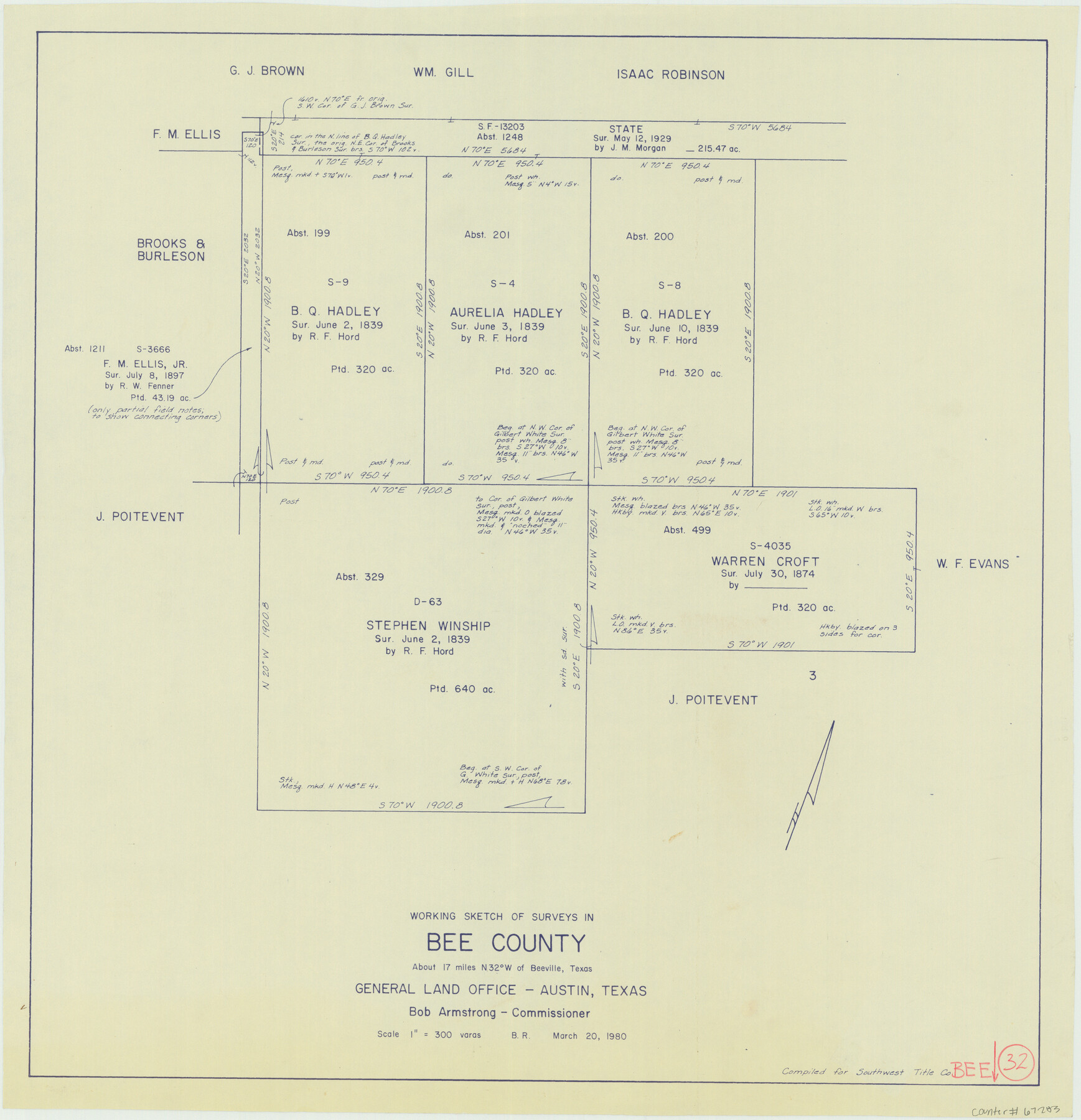
Bee County Working Sketch 32
- 
                          Map/Doc
67283
 - 
                            Collection
General Map Collection
 - 
                            Object Dates
3/20/1980 (Creation Date)
 - 
                            People and Organizations
Bob Armstrong (GLO Commissioner)
Beverly Robison (Draftsman)
 - 
                            Counties
Bee
 - 
                            Subjects
Surveying Working Sketch
 - 
                            Height x Width
21.7 x 21.0 inches
55.1 x 53.3 cm
 - 
                            Scale
1" = 300 varas
 - 
                            Comments
Surveys located about 17 miles North 32 degrees West of Beeville, Texas.
 
Part of: General Map Collection
            Crane County Sketch File 6


                                            Print $20.00                    
                                             -                         Digital $50.00                                    
                Crane County Sketch File 6
Size 18.7 x 22.8 inches
                                Map/Doc 11207
            
            Flight Mission No. BRA-16M, Frame 115, Jefferson County


                                            Print $20.00                    
                                             -                         Digital $50.00                                    
                Flight Mission No. BRA-16M, Frame 115, Jefferson County
1953
Size 18.5 x 22.2 inches
                                Map/Doc 85725
            
            Brazoria County Working Sketch 1


                                            Print $20.00                    
                                             -                         Digital $50.00                                    
                Brazoria County Working Sketch 1
1907
Size 19.6 x 19.0 inches
                                Map/Doc 67486
            
            Robertson County Working Sketch 15


                                            Print $20.00                    
                                             -                         Digital $50.00                                    
                Robertson County Working Sketch 15
1984
Size 28.7 x 25.2 inches
                                Map/Doc 63588
            
            Jefferson County Working Sketch 39


                                            Print $20.00                    
                                             -                         Digital $50.00                                    
                Jefferson County Working Sketch 39
1984
Size 39.3 x 28.2 inches
                                Map/Doc 66583
            
            Coast Chart No. 210 - Aransas Pass and Corpus Christi Bay with the coast to latitude 27° 12', Texas


                                            Print $20.00                    
                                             -                         Digital $50.00                                    
                Coast Chart No. 210 - Aransas Pass and Corpus Christi Bay with the coast to latitude 27° 12', Texas
1887
Size 23.4 x 29.4 inches
                                Map/Doc 73443
            
            Controlled Mosaic by Jack Amman Photogrammetric Engineers, Inc - Sheet 20


                                            Print $20.00                    
                                             -                         Digital $50.00                                    
                Controlled Mosaic by Jack Amman Photogrammetric Engineers, Inc - Sheet 20
1954
Size 20.0 x 24.0 inches
                                Map/Doc 83466
            
            Martin County Working Sketch 10


                                            Print $40.00                    
                                             -                         Digital $50.00                                    
                Martin County Working Sketch 10
1971
Size 50.0 x 37.4 inches
                                Map/Doc 70828
            
            Erath County Sketch File 16


                                            Print $4.00                    
                                             -                         Digital $50.00                                    
                Erath County Sketch File 16
1872
Size 12.9 x 8.3 inches
                                Map/Doc 22294
            
            Jeff Davis County Rolled Sketch 38


                                            Print $20.00                    
                                             -                         Digital $50.00                                    
                Jeff Davis County Rolled Sketch 38
1994
Size 26.1 x 35.1 inches
                                Map/Doc 6381
            
            Pecos County Sketch File 112


                                            Print $16.00                    
                                             -                         Digital $50.00                                    
                Pecos County Sketch File 112
1892
Size 11.2 x 8.6 inches
                                Map/Doc 34061
            
            Hood County Working Sketch 2


                                            Print $20.00                    
                                             -                         Digital $50.00                                    
                Hood County Working Sketch 2
1956
Size 20.5 x 25.5 inches
                                Map/Doc 66196
            You may also like
            Goliad County Working Sketch 4


                                            Print $20.00                    
                                             -                         Digital $50.00                                    
                Goliad County Working Sketch 4
1920
Size 30.5 x 30.0 inches
                                Map/Doc 63194
            
            Gulf Intracoastal Waterway - Aransas Bay to Corpus Christi Bay - Modified Route Main Channel


                                            Print $20.00                    
                                             -                         Digital $50.00                                    
                Gulf Intracoastal Waterway - Aransas Bay to Corpus Christi Bay - Modified Route Main Channel
1960
Size 31.3 x 42.7 inches
                                Map/Doc 61902
            
            Brazoria County Working Sketch 30


                                            Print $20.00                    
                                             -                         Digital $50.00                                    
                Brazoria County Working Sketch 30
1974
Size 37.5 x 43.8 inches
                                Map/Doc 67515
            
            Montague County Sketch File 2


                                            Print $24.00                    
                                             -                         Digital $50.00                                    
                Montague County Sketch File 2
1856
Size 12.0 x 8.5 inches
                                Map/Doc 31711
            
            [Beaumont, Sour Lake and Western Ry. Right of Way and Alignment - Frisco]


                                            Print $20.00                    
                                             -                         Digital $50.00                                    
                [Beaumont, Sour Lake and Western Ry. Right of Way and Alignment - Frisco]
1910
Size 20.3 x 46.2 inches
                                Map/Doc 64109
            
            [Map showing T&P Lands in El Paso County]


                                            Print $20.00                    
                                    
                [Map showing T&P Lands in El Paso County]
Size 22.2 x 17.1 inches
                                Map/Doc 88932
            
            Map of Concho County


                                            Print $20.00                    
                                             -                         Digital $50.00                                    
                Map of Concho County
1879
Size 23.4 x 18.3 inches
                                Map/Doc 4523
            
            Aransas County NRC Article 33.136 Sketch 3


                                            Print $20.00                    
                                             -                         Digital $50.00                                    
                Aransas County NRC Article 33.136 Sketch 3
2003
Size 25.1 x 36.1 inches
                                Map/Doc 80138
            
            Erath County Sketch File 11


                                            Print $4.00                    
                                             -                         Digital $50.00                                    
                Erath County Sketch File 11
1871
Size 12.8 x 8.1 inches
                                Map/Doc 22279
            
            Hopkins County Boundary File 1


                                            Print $26.00                    
                                             -                         Digital $50.00                                    
                Hopkins County Boundary File 1
Size 12.3 x 7.9 inches
                                Map/Doc 55044
            
            Goliad County Sketch File 16


                                            Print $40.00                    
                                             -                         Digital $50.00                                    
                Goliad County Sketch File 16
Size 13.4 x 15.8 inches
                                Map/Doc 24247
            
            [County School Land Leagues]


                                            Print $20.00                    
                                             -                         Digital $50.00                                    
                [County School Land Leagues]
1913
Size 21.2 x 25.4 inches
                                Map/Doc 90280