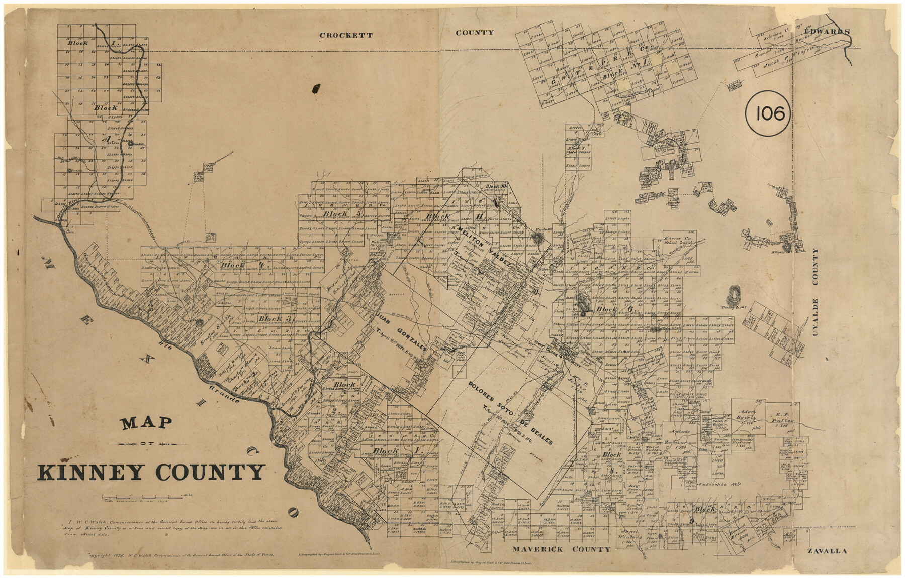
Map of Kinney County, Texas
-
Map/Doc
548
-
Collection
Maddox Collection
-
Object Dates
1879 (Creation Date)
-
People and Organizations
General Land Office (Publisher)
August Gast & Co. (Lithographer)
-
Counties
Kinney
-
Subjects
County
-
Height x Width
21.2 x 33.1 inches
53.9 x 84.1 cm
-
Medium
paper, etching/engraving/lithograph
-
Scale
1" = 4000 varas
-
Comments
Conservation funded in 2009.
-
Features
Pisaro Pinto Creek
Mud Creek
El Paso Road
Sycamore Creek
Las Manos Mountain
Olmos Mountain
Turkey Cr[eek] Mountain
W[est] P[rong] of Nueces [River]
Fort Clark
Bracckett [sic]
Sycamore Creek
Sacatose Creek
Rio Grande
Gladesburg
Las Moras Creek
Stage Stand [on El Paso Road]
Elm Creek
Lindsay Creek
Cow Creek
Salado Creek
Chaparosa Creek
Lower Pinto Creek
E[ast] P[rong] of San Pedro Arroyo
Onion Creek
Seneguas Creek
West [Pinto Creek]
Ellipsis Mountain
Griffin Creek
Lone Hill
W[est] F[ork] of Painted Cape Creek
Live Oak Creek
[Road] to Griffin Valley
Maverick Creek
Devil's River
[Road] to Fort Lancaster and Camp Hudson
Road to Fort Lancaster
Road to Camp Hudson
Sinegas Creek
Pinto Mountain
West Fork of Nueces River
Grass Valley Creek
[Road] to Nueces River and Fort McKavitt
Road to Nueces River
Road to Fort McKavitt
Bluff Creek
Little Pinto Mountain
East Pinto Creek
Big Perdido [Creek]
Little Perdido Creek
San Felipe
Conical Hill
Part of: Maddox Collection
Baylor County, Texas

Print $20.00
- Digital $50.00
Baylor County, Texas
Size 21.7 x 18.9 inches
Map/Doc 525
Sketch of Survey 3, Block 1 in Dickens and King Counties

Print $20.00
- Digital $50.00
Sketch of Survey 3, Block 1 in Dickens and King Counties
1914
Size 10.8 x 28.2 inches
Map/Doc 10766
Resurvey of H.L. Upshur's April 23, 1853 meanders of the Colorado River from the NE corner of Isaac Decker league to the Congress Avenue Bridge

Print $20.00
- Digital $50.00
Resurvey of H.L. Upshur's April 23, 1853 meanders of the Colorado River from the NE corner of Isaac Decker league to the Congress Avenue Bridge
1915
Size 24.1 x 15.8 inches
Map/Doc 75774
Wise County, Texas

Print $20.00
- Digital $50.00
Wise County, Texas
1871
Size 21.9 x 18.7 inches
Map/Doc 766
Plat Town of Swearingen, Cottle Co., Texas

Print $20.00
- Digital $50.00
Plat Town of Swearingen, Cottle Co., Texas
1918
Size 40.6 x 30.6 inches
Map/Doc 4466
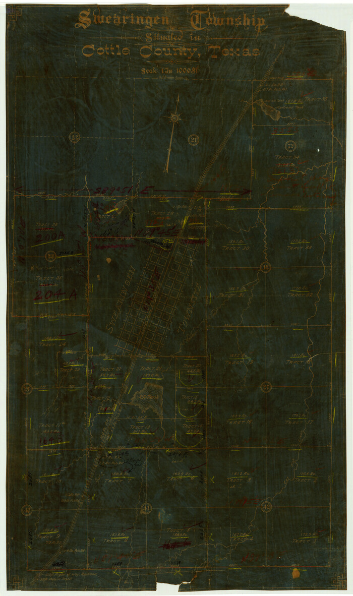
Swearingen Township situated in Cottle County, Texas
Print $20.00
- Digital $50.00
Swearingen Township situated in Cottle County, Texas
Size 26.4 x 15.7 inches
Map/Doc 4437
Map of Runnels County, Texas

Print $20.00
- Digital $50.00
Map of Runnels County, Texas
1879
Size 28.7 x 22.5 inches
Map/Doc 604
[Sketch in Hutchinson County, Texas]
![4491, [Sketch in Hutchinson County, Texas], Maddox Collection](https://historictexasmaps.com/wmedia_w700/maps/4491.tif.jpg)
Print $20.00
- Digital $50.00
[Sketch in Hutchinson County, Texas]
Size 36.2 x 31.1 inches
Map/Doc 4491
Sketch of Garza Co.

Print $3.00
- Digital $50.00
Sketch of Garza Co.
1884
Size 12.3 x 10.2 inches
Map/Doc 468
[San Antonio del Encinal Survey and Surveys West Thereof, Brooks County, Texas]
![10773, [San Antonio del Encinal Survey and Surveys West Thereof, Brooks County, Texas], Maddox Collection](https://historictexasmaps.com/wmedia_w700/maps/10773.tif.jpg)
Print $20.00
- Digital $50.00
[San Antonio del Encinal Survey and Surveys West Thereof, Brooks County, Texas]
Size 18.6 x 24.6 inches
Map/Doc 10773
[Sketch Showing Blocks in Hansford County, Texas]
![75818, [Sketch Showing Blocks in Hansford County, Texas], Maddox Collection](https://historictexasmaps.com/wmedia_w700/maps/75818.tif.jpg)
Print $20.00
- Digital $50.00
[Sketch Showing Blocks in Hansford County, Texas]
1890
Size 34.3 x 24.6 inches
Map/Doc 75818
Hopkins County

Print $20.00
- Digital $50.00
Hopkins County
1888
Size 36.4 x 36.6 inches
Map/Doc 448
You may also like
General Highway Map, Jefferson County, Texas

Print $20.00
General Highway Map, Jefferson County, Texas
1961
Size 24.6 x 18.3 inches
Map/Doc 79537
Schleicher County Rolled Sketch 8

Print $20.00
- Digital $50.00
Schleicher County Rolled Sketch 8
Size 27.8 x 29.0 inches
Map/Doc 7750
Flight Mission No. CON-2R, Frame 116, Stonewall County

Print $20.00
- Digital $50.00
Flight Mission No. CON-2R, Frame 116, Stonewall County
1957
Size 18.3 x 22.2 inches
Map/Doc 86990
Palo Pinto County Working Sketch 7

Print $20.00
- Digital $50.00
Palo Pinto County Working Sketch 7
1922
Map/Doc 71390
Hudspeth County Sketch File 13

Print $18.00
- Digital $50.00
Hudspeth County Sketch File 13
1915
Size 13.3 x 8.9 inches
Map/Doc 26929
Flight Mission No. BRA-7M, Frame 138, Jefferson County

Print $20.00
- Digital $50.00
Flight Mission No. BRA-7M, Frame 138, Jefferson County
1953
Size 18.6 x 22.4 inches
Map/Doc 85532
[Surveys to the North and West of the Francis Blundell survey containing townsite]
![90884, [Surveys to the North and West of the Francis Blundell survey containing townsite], Twichell Survey Records](https://historictexasmaps.com/wmedia_w700/maps/90884-1.tif.jpg)
Print $20.00
- Digital $50.00
[Surveys to the North and West of the Francis Blundell survey containing townsite]
Size 26.3 x 19.8 inches
Map/Doc 90884
Cass County Sketch File 5 and 5a

Print $6.00
- Digital $50.00
Cass County Sketch File 5 and 5a
1851
Size 2.8 x 5.1 inches
Map/Doc 17401
Upton County Rolled Sketch 9

Print $20.00
- Digital $50.00
Upton County Rolled Sketch 9
1911
Size 15.3 x 27.0 inches
Map/Doc 8068
Record of Spanish Titles, Vol. IV

Record of Spanish Titles, Vol. IV
Size 19.2 x 12.8 inches
Map/Doc 94529
Gregg County Rolled Sketch 17

Print $20.00
- Digital $50.00
Gregg County Rolled Sketch 17
1933
Size 14.0 x 27.9 inches
Map/Doc 6040
Flight Mission No. CGI-3N, Frame 174, Cameron County

Print $20.00
- Digital $50.00
Flight Mission No. CGI-3N, Frame 174, Cameron County
1954
Size 18.5 x 22.1 inches
Map/Doc 84638