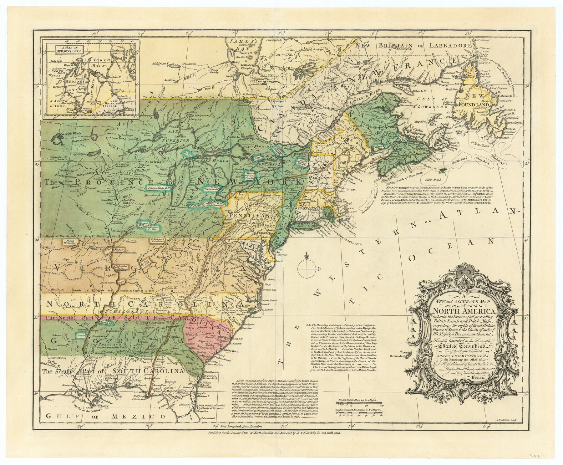
A new and accurate map of North America (wherein the errors of all preceeding British, French and Dutch maps, respecting the rights of Great Britain, France & Spain, & the limits of each of His Majesty's provinces, are corrected)
-
Map/Doc
97416
-
Collection
General Map Collection
-
Object Dates
1755 (Creation Date)
-
People and Organizations
John Huske (Draftsman)
-
Subjects
North America
-
Height x Width
18.3 x 22.1 inches
46.5 x 56.1 cm
-
Comments
Relief shown by shading.
"All the coloured part of this map ... delineates the rights and possessions of Great Britain ...
Includes inset, "A map of Hudson's Bay &c."
Part of: General Map Collection
Flight Mission No. BRA-16M, Frame 144, Jefferson County

Print $20.00
- Digital $50.00
Flight Mission No. BRA-16M, Frame 144, Jefferson County
1953
Size 18.6 x 22.5 inches
Map/Doc 85750
El Paso County Working Sketch 24

Print $20.00
- Digital $50.00
El Paso County Working Sketch 24
1961
Size 26.4 x 22.0 inches
Map/Doc 69046
Fort Bend County Working Sketch 26

Print $4.00
- Digital $50.00
Fort Bend County Working Sketch 26
1982
Size 18.5 x 23.6 inches
Map/Doc 69232
Reagan County Working Sketch 10

Print $20.00
- Digital $50.00
Reagan County Working Sketch 10
1942
Size 21.5 x 27.2 inches
Map/Doc 71850
Lavaca County Sketch File 7

Print $4.00
- Digital $50.00
Lavaca County Sketch File 7
1873
Size 7.9 x 9.8 inches
Map/Doc 29642
Jeff Davis County Rolled Sketch 22

Print $399.00
- Digital $50.00
Jeff Davis County Rolled Sketch 22
Size 17.2 x 15.8 inches
Map/Doc 6487
Hays County Sketch File 4

Print $4.00
- Digital $50.00
Hays County Sketch File 4
Size 8.5 x 7.0 inches
Map/Doc 26204
Henderson County Rolled Sketch 14

Print $20.00
- Digital $50.00
Henderson County Rolled Sketch 14
2012
Size 19.3 x 32.3 inches
Map/Doc 95715
Pecos County Working Sketch 107

Print $40.00
- Digital $50.00
Pecos County Working Sketch 107
1971
Size 55.3 x 37.4 inches
Map/Doc 71580
Maverick County Sketch File 1 1/2

Print $20.00
- Digital $50.00
Maverick County Sketch File 1 1/2
1875
Size 23.2 x 27.6 inches
Map/Doc 12049
Deaf Smith County Sketch File D(a)

Print $30.00
- Digital $50.00
Deaf Smith County Sketch File D(a)
1905
Size 9.4 x 8.8 inches
Map/Doc 20643
Bee County Working Sketch 26

Print $20.00
- Digital $50.00
Bee County Working Sketch 26
1987
Size 30.9 x 36.0 inches
Map/Doc 67276
You may also like
Brewster County Rolled Sketch 60

Print $40.00
- Digital $50.00
Brewster County Rolled Sketch 60
Size 36.7 x 50.8 inches
Map/Doc 9200
Subdivision of Sutton County School League 175, Bailey County, Texas

Print $2.00
- Digital $50.00
Subdivision of Sutton County School League 175, Bailey County, Texas
1929
Size 8.9 x 11.5 inches
Map/Doc 90201
Travis County Boundary File 2

Print $42.00
- Digital $50.00
Travis County Boundary File 2
Size 9.3 x 7.2 inches
Map/Doc 59406
Hardeman County Working Sketch 17

Print $20.00
- Digital $50.00
Hardeman County Working Sketch 17
1986
Size 18.4 x 26.1 inches
Map/Doc 63398
Wood County Rolled Sketch 1

Print $40.00
- Digital $50.00
Wood County Rolled Sketch 1
1941
Size 53.2 x 43.8 inches
Map/Doc 10159
Jasper County Working Sketch 33

Print $6.00
- Digital $50.00
Jasper County Working Sketch 33
1999
Size 30.4 x 17.5 inches
Map/Doc 66495
Brazoria County Rolled Sketch 34

Print $20.00
- Digital $50.00
Brazoria County Rolled Sketch 34
1944
Size 29.8 x 18.3 inches
Map/Doc 5171
Amistad International Reservoir on Rio Grande 104

Print $20.00
- Digital $50.00
Amistad International Reservoir on Rio Grande 104
1950
Size 28.5 x 40.9 inches
Map/Doc 75535
Fort Bend County Sketch File 18a

Print $42.00
- Digital $50.00
Fort Bend County Sketch File 18a
1890
Size 14.7 x 8.7 inches
Map/Doc 22940

The Chief Justice County of Liberty. April 25, 1837

Print $20.00
The Chief Justice County of Liberty. April 25, 1837
2020
Size 20.5 x 21.7 inches
Map/Doc 96055
Tyler County Sketch File 19

Print $4.00
- Digital $50.00
Tyler County Sketch File 19
Size 3.5 x 6.1 inches
Map/Doc 38670