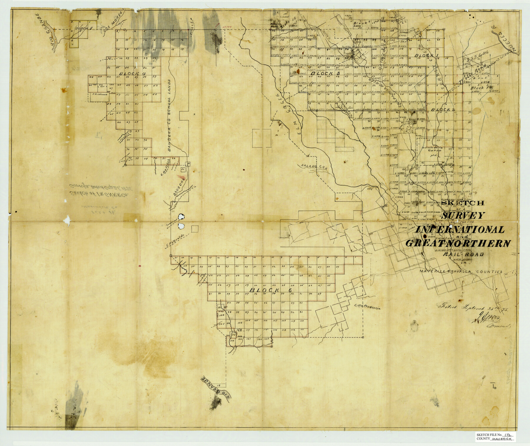
Maverick County Sketch File 1 1/2
Sketch of a survey made for the International and Great Northern Railroad in Maverick and Zavala Counties
-
Map/Doc
12049
-
Collection
General Map Collection
-
Object Dates
9/25/1875 (Creation Date)
-
Counties
Maverick Zavala
-
Subjects
Surveying Sketch File
-
Height x Width
23.2 x 27.6 inches
58.9 x 70.1 cm
-
Medium
paper, manuscript
-
Comments
Shows I. & G. N. Blocks in Maverick and Zavala Counties.
-
Features
Rio Grande
Los Mores Creek
Muela Creek
Chaparosa Creek
Gato Creek
Nueces River
Turkey Creek
Woll's Road
Palo Blanco Creek
E[l] P[aso] & Ft. Cl[ar]k Road
Saus Creek
Salado Creek
El[l] P[aso] & Uvalde Road
E[l] P[aso] & Pendencia Road
Part of: General Map Collection
Castro County Working Sketch 9

Print $20.00
- Digital $50.00
Castro County Working Sketch 9
1965
Size 43.1 x 47.7 inches
Map/Doc 68646
Map of the survey of the 100th Meridian of longitude west of Greenwich beginning at Red River and extending to the parallel 36 1/2 degrees north latitude

Print $40.00
- Digital $50.00
Map of the survey of the 100th Meridian of longitude west of Greenwich beginning at Red River and extending to the parallel 36 1/2 degrees north latitude
1862
Size 111.9 x 10.4 inches
Map/Doc 3094
Van Zandt County Sketch File 27a

Print $22.00
- Digital $50.00
Van Zandt County Sketch File 27a
1894
Size 17.4 x 14.5 inches
Map/Doc 39449
Bastrop County Rolled Sketch 6

Print $20.00
- Digital $50.00
Bastrop County Rolled Sketch 6
2013
Size 42.3 x 32.1 inches
Map/Doc 93716
Presidio County Rolled Sketch 144

Print $20.00
- Digital $50.00
Presidio County Rolled Sketch 144
2010
Size 36.0 x 24.0 inches
Map/Doc 89602
Shackelford County

Print $20.00
- Digital $50.00
Shackelford County
1920
Size 44.6 x 37.1 inches
Map/Doc 16813
Flight Mission No. BRA-7M, Frame 183, Jefferson County

Print $20.00
- Digital $50.00
Flight Mission No. BRA-7M, Frame 183, Jefferson County
1953
Size 18.6 x 22.3 inches
Map/Doc 85551
Jefferson County Working Sketch 13

Print $20.00
- Digital $50.00
Jefferson County Working Sketch 13
1948
Size 13.5 x 20.1 inches
Map/Doc 66556
Winkler County Rolled Sketch 11

Print $20.00
- Digital $50.00
Winkler County Rolled Sketch 11
1965
Size 37.4 x 34.2 inches
Map/Doc 10152
Flight Mission No. BQR-7K, Frame 33, Brazoria County

Print $20.00
- Digital $50.00
Flight Mission No. BQR-7K, Frame 33, Brazoria County
1952
Size 18.7 x 22.3 inches
Map/Doc 84031

Northeast Part Presidio County

Print $20.00
- Digital $50.00
Northeast Part Presidio County
1973
Size 42.3 x 33.4 inches
Map/Doc 95616
You may also like
Hutchinson County Working Sketch 35

Print $20.00
- Digital $50.00
Hutchinson County Working Sketch 35
1978
Size 27.0 x 22.3 inches
Map/Doc 66395
Comanche County Sketch File 19

Print $12.00
- Digital $50.00
Comanche County Sketch File 19
Size 13.0 x 8.0 inches
Map/Doc 19093
[Blocks 47, Z, XO2, M18, M23, M25, and H]
![91186, [Blocks 47, Z, XO2, M18, M23, M25, and H], Twichell Survey Records](https://historictexasmaps.com/wmedia_w700/maps/91186-1.tif.jpg)
Print $20.00
- Digital $50.00
[Blocks 47, Z, XO2, M18, M23, M25, and H]
Size 30.1 x 23.5 inches
Map/Doc 91186
La Salle County Working Sketch 51

Print $20.00
- Digital $50.00
La Salle County Working Sketch 51
1990
Size 33.9 x 29.9 inches
Map/Doc 70352
Flight Mission No. BRA-7M, Frame 181, Jefferson County

Print $20.00
- Digital $50.00
Flight Mission No. BRA-7M, Frame 181, Jefferson County
1953
Size 18.6 x 22.4 inches
Map/Doc 85549
Sulphur River, Harts Bluff Sheet

Print $20.00
- Digital $50.00
Sulphur River, Harts Bluff Sheet
1919
Size 23.3 x 30.3 inches
Map/Doc 65159
Goliad County Sketch File 36

Print $20.00
- Digital $50.00
Goliad County Sketch File 36
1925
Size 17.1 x 14.1 inches
Map/Doc 11571
Brewster County Working Sketch 10

Print $20.00
- Digital $50.00
Brewster County Working Sketch 10
1910
Size 17.8 x 16.8 inches
Map/Doc 67543
Map of Kimble County

Print $20.00
- Digital $50.00
Map of Kimble County
1879
Size 18.7 x 28.9 inches
Map/Doc 3765
Current Miscellaneous File 81

Print $14.00
- Digital $50.00
Current Miscellaneous File 81
1942
Size 14.2 x 8.9 inches
Map/Doc 74217
Plan of the City of Austin

Print $20.00
Plan of the City of Austin
1839
Size 24.2 x 19.4 inches
Map/Doc 76204
Duval County Working Sketch 15

Print $20.00
- Digital $50.00
Duval County Working Sketch 15
1938
Size 23.3 x 22.7 inches
Map/Doc 68728