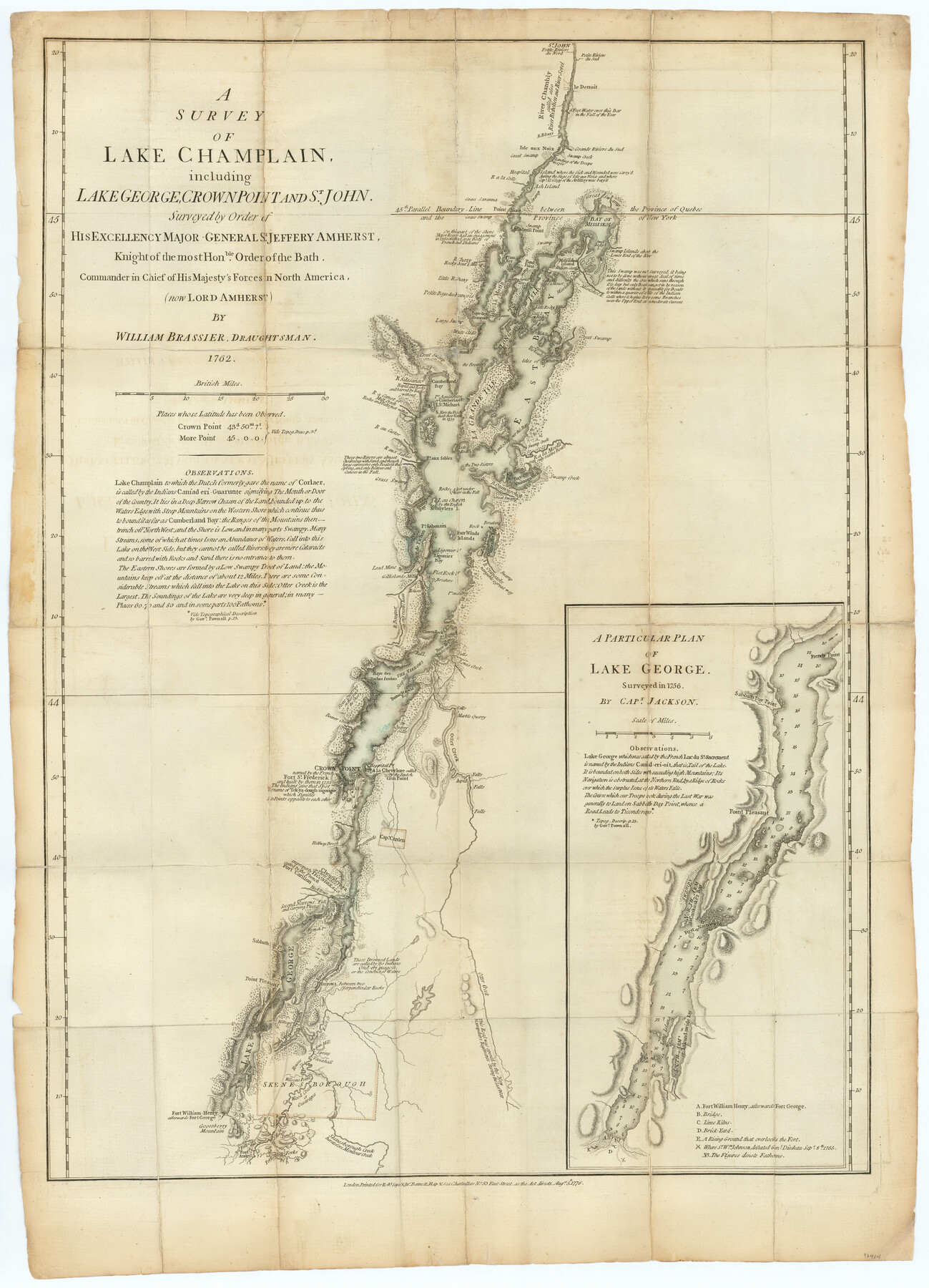
A Survey of Lake Champlain, including Lake George, Crown Point and St. John
Inset Map: A Particular Plan of Lake George
-
Map/Doc
97404
-
Collection
General Map Collection
-
Object Dates
1762 (Creation Date)
8/5/1776 (Publication Date)
-
People and Organizations
William Furness Brassier (Draftsman)
-
Height x Width
29.0 x 20.9 inches
73.7 x 53.1 cm
-
Comments
This map appeared in "The American Military Pocket Atlas; being an approved Collection of Correct Maps, both general and particular, of the British Colonies; Especially those which now are, or probably may be the Theatre of War" (97398)
Related maps
The American Military Pocket Atlas; being an approved Collection of Correct Maps, both general and particular, of the British Colonies; Especially those which now are, or probably may be the Theatre of War

The American Military Pocket Atlas; being an approved Collection of Correct Maps, both general and particular, of the British Colonies; Especially those which now are, or probably may be the Theatre of War
1776
Map/Doc 97398
North America, as divided amongst the European Powers

Print $20.00
- Digital $50.00
North America, as divided amongst the European Powers
1774
Size 14.1 x 18.7 inches
Map/Doc 97399
A Compleat Map of the West Indies, containing the Coasts of Florida, Louisiana, New Spain, and Terra Firma: with all the Islands

Print $20.00
- Digital $50.00
A Compleat Map of the West Indies, containing the Coasts of Florida, Louisiana, New Spain, and Terra Firma: with all the Islands
1774
Size 13.9 x 19.0 inches
Map/Doc 97400
A General Map of the Northern British Colonies in America which comprehends the Province of Quebec, the Government of Newfoundland, Nova-Scotia, New England and New York

Print $20.00
- Digital $50.00
A General Map of the Northern British Colonies in America which comprehends the Province of Quebec, the Government of Newfoundland, Nova-Scotia, New England and New York
1776
Size 21.3 x 27.3 inches
Map/Doc 97401
A General Map of the Middle British Colonies, in America. containing Virginia, Maryland, the Delaware Counties, Pennsylvania and New Jersey. With the addition of New York and of the Greatest Part of New England

Print $20.00
- Digital $50.00
A General Map of the Middle British Colonies, in America. containing Virginia, Maryland, the Delaware Counties, Pennsylvania and New Jersey. With the addition of New York and of the Greatest Part of New England
1776
Size 21.6 x 27.2 inches
Map/Doc 97402
A General Map of the Southern British Colonies, in America. comprehending North and South Carolina, Georgia, East and West Florida, with the Neighbouring Indian Countries

Print $20.00
- Digital $50.00
A General Map of the Southern British Colonies, in America. comprehending North and South Carolina, Georgia, East and West Florida, with the Neighbouring Indian Countries
1776
Size 21.3 x 26.4 inches
Map/Doc 97403
Part of: General Map Collection
Brazoria County Rolled Sketch 30

Print $20.00
- Digital $50.00
Brazoria County Rolled Sketch 30
1940
Size 17.8 x 22.9 inches
Map/Doc 5168
[Sketch for Mineral Application 26501 - Sabine River, T. A. Oldhausen]
![2832, [Sketch for Mineral Application 26501 - Sabine River, T. A. Oldhausen], General Map Collection](https://historictexasmaps.com/wmedia_w700/maps/2832.tif.jpg)
Print $20.00
- Digital $50.00
[Sketch for Mineral Application 26501 - Sabine River, T. A. Oldhausen]
1931
Size 24.0 x 36.0 inches
Map/Doc 2832
Cameron County Rolled Sketch 20E

Print $20.00
- Digital $50.00
Cameron County Rolled Sketch 20E
Size 12.9 x 11.4 inches
Map/Doc 5479
San Patricio County Sketch File 20

Print $14.00
San Patricio County Sketch File 20
1868
Size 9.2 x 8.5 inches
Map/Doc 36069
Terrell County Rolled Sketch W

Print $20.00
- Digital $50.00
Terrell County Rolled Sketch W
Size 15.4 x 14.3 inches
Map/Doc 7979
Jackson County NRC Article 33.136 Sketch 1

Print $66.00
- Digital $50.00
Jackson County NRC Article 33.136 Sketch 1
2013
Size 34.0 x 22.0 inches
Map/Doc 94950
Brewster County Rolled Sketch 139

Print $20.00
- Digital $50.00
Brewster County Rolled Sketch 139
1982
Size 24.4 x 38.0 inches
Map/Doc 5307
Orange County Working Sketch 31

Print $20.00
- Digital $50.00
Orange County Working Sketch 31
1955
Size 24.2 x 13.8 inches
Map/Doc 71363
Flight Mission No. BQY-4M, Frame 37, Harris County

Print $20.00
- Digital $50.00
Flight Mission No. BQY-4M, Frame 37, Harris County
1953
Size 18.6 x 22.3 inches
Map/Doc 85252
City of Austin, Texas and Suburban Areas

Print $40.00
- Digital $50.00
City of Austin, Texas and Suburban Areas
1964
Size 48.3 x 34.4 inches
Map/Doc 73563
Stephens County Sketch File 10c

Print $6.00
- Digital $50.00
Stephens County Sketch File 10c
Size 7.8 x 11.5 inches
Map/Doc 37052
[Sketch for Mineral Application 19443 - Brazos River]
![65682, [Sketch for Mineral Application 19443 - Brazos River], General Map Collection](https://historictexasmaps.com/wmedia_w700/maps/65682.tif.jpg)
Print $40.00
- Digital $50.00
[Sketch for Mineral Application 19443 - Brazos River]
1853
Size 117.6 x 30.2 inches
Map/Doc 65682
You may also like
Duval County Working Sketch 36

Print $20.00
- Digital $50.00
Duval County Working Sketch 36
1957
Size 36.1 x 26.0 inches
Map/Doc 68760
[Surveys in Austin County]
![35, [Surveys in Austin County], General Map Collection](https://historictexasmaps.com/wmedia_w700/maps/35.tif.jpg)
Print $20.00
- Digital $50.00
[Surveys in Austin County]
1840
Size 20.8 x 28.2 inches
Map/Doc 35
Howard County Rolled Sketch 5

Print $20.00
- Digital $50.00
Howard County Rolled Sketch 5
Size 19.6 x 16.5 inches
Map/Doc 6234
Lampasas County Working Sketch 15

Print $20.00
- Digital $50.00
Lampasas County Working Sketch 15
1975
Size 28.5 x 23.8 inches
Map/Doc 70292
United States - Gulf Coast - From Latitude 26° 33' to the Rio Grande Texas

Print $20.00
- Digital $50.00
United States - Gulf Coast - From Latitude 26° 33' to the Rio Grande Texas
1918
Size 18.4 x 24.3 inches
Map/Doc 72846
Presidio County Rolled Sketch 65

Print $20.00
- Digital $50.00
Presidio County Rolled Sketch 65
Size 23.1 x 28.3 inches
Map/Doc 7356
[Block C39, Sections 22, 23 Millican Estate, 24]
![92345, [Block C39, Sections 22, 23 Millican Estate, 24], Twichell Survey Records](https://historictexasmaps.com/wmedia_w700/maps/92345-1.tif.jpg)
Print $20.00
- Digital $50.00
[Block C39, Sections 22, 23 Millican Estate, 24]
1956
Size 11.4 x 31.2 inches
Map/Doc 92345
Pecos County Sketch File 74

Print $8.00
- Digital $50.00
Pecos County Sketch File 74
1941
Size 14.1 x 8.8 inches
Map/Doc 33900
[H. & T. C. , Block 47, Sections 26- 38]
![91255, [H. & T. C. , Block 47, Sections 26- 38], Twichell Survey Records](https://historictexasmaps.com/wmedia_w700/maps/91255-1.tif.jpg)
Print $2.00
- Digital $50.00
[H. & T. C. , Block 47, Sections 26- 38]
Size 14.5 x 9.2 inches
Map/Doc 91255
Webb County Sketch File 4

Print $22.00
- Digital $50.00
Webb County Sketch File 4
1855
Size 8.4 x 14.2 inches
Map/Doc 39716
Leon County Rolled Sketch 9

Print $40.00
- Digital $50.00
Leon County Rolled Sketch 9
1960
Size 50.1 x 35.2 inches
Map/Doc 9430
El Paso County State Real Property Sketch 1

Print $20.00
- Digital $50.00
El Paso County State Real Property Sketch 1
2007
Size 24.1 x 36.2 inches
Map/Doc 88670