Brewster County Rolled Sketch 139
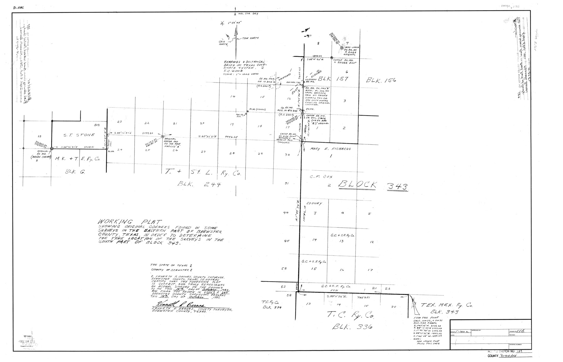
Working plat showing original corners found in some surveys in the eastern part of Brewster County, Texas in order to determine the true location of the surveys in the south part of Block 343
-
Map/Doc
5307
-
Collection
General Map Collection
-
Object Dates
1982/10/14 (Creation Date)
1982/10/30 (File Date)
-
People and Organizations
Kenneth R. Barnes (Surveyor/Engineer)
-
Counties
Brewster
-
Subjects
Surveying Rolled Sketch
-
Height x Width
24.4 x 38.0 inches
62.0 x 96.5 cm
-
Medium
mylar, print
-
Scale
1" = 1000 varas
Part of: General Map Collection
Colorado River, Wharton Sheet

Print $6.00
- Digital $50.00
Colorado River, Wharton Sheet
1941
Size 27.3 x 35.7 inches
Map/Doc 65314
Morris County Rolled Sketch 2A

Print $20.00
- Digital $50.00
Morris County Rolled Sketch 2A
Size 24.1 x 18.9 inches
Map/Doc 10261
Baylor County Sketch File 12C

Print $8.00
- Digital $50.00
Baylor County Sketch File 12C
1900
Size 13.5 x 8.8 inches
Map/Doc 14155
Shelby County

Print $40.00
- Digital $50.00
Shelby County
1897
Size 43.9 x 49.3 inches
Map/Doc 16814
Castro County Sketch File 15

Print $4.00
- Digital $50.00
Castro County Sketch File 15
1978
Size 11.2 x 8.7 inches
Map/Doc 17511
Brewster County Working Sketch 57

Print $20.00
- Digital $50.00
Brewster County Working Sketch 57
1954
Size 19.6 x 20.8 inches
Map/Doc 67658
University Land, Winkler-Andrews-Gaines-Dawson-Martin Counties

Print $40.00
- Digital $50.00
University Land, Winkler-Andrews-Gaines-Dawson-Martin Counties
1931
Size 42.3 x 52.1 inches
Map/Doc 2419
Flight Mission No. DQO-3K, Frame 24, Galveston County

Print $20.00
- Digital $50.00
Flight Mission No. DQO-3K, Frame 24, Galveston County
1952
Size 18.7 x 22.4 inches
Map/Doc 85065
Crosby County Sketch File 34

Print $4.00
- Digital $50.00
Crosby County Sketch File 34
1892
Size 11.3 x 8.9 inches
Map/Doc 20104
Texas Panhandle East Boundary Line

Print $40.00
- Digital $50.00
Texas Panhandle East Boundary Line
1898
Size 9.2 x 64.9 inches
Map/Doc 1716
Zapata County Boundary File 1

Print $2.00
- Digital $50.00
Zapata County Boundary File 1
Size 11.4 x 9.0 inches
Map/Doc 60227
Galveston Harbor and Channel, Texas - Rehabilitation of Galveston Groins - Location Plan of Rehabilitation

Print $4.00
- Digital $50.00
Galveston Harbor and Channel, Texas - Rehabilitation of Galveston Groins - Location Plan of Rehabilitation
1968
Size 19.7 x 21.5 inches
Map/Doc 73627
You may also like

Coryell County Boundary File 1b

Print $68.00
- Digital $50.00
Coryell County Boundary File 1b
Size 18.1 x 16.1 inches
Map/Doc 51894
Plat of a survey of the North part of section 16, Block 362, Martha McBride, Presidio County, Texas

Print $6.00
- Digital $50.00
Plat of a survey of the North part of section 16, Block 362, Martha McBride, Presidio County, Texas
1989
Size 25.5 x 35.0 inches
Map/Doc 60521
Red River County Working Sketch 30

Print $20.00
- Digital $50.00
Red River County Working Sketch 30
1962
Size 25.2 x 22.8 inches
Map/Doc 72013
Erath County Working Sketch 9

Print $20.00
- Digital $50.00
Erath County Working Sketch 9
1939
Size 18.6 x 14.8 inches
Map/Doc 69090
Brown County Sketch File 11a

Print $6.00
- Digital $50.00
Brown County Sketch File 11a
1872
Size 6.6 x 3.6 inches
Map/Doc 16599
Central Part of Jeff Davis Co.

Print $40.00
- Digital $50.00
Central Part of Jeff Davis Co.
1982
Size 54.2 x 41.6 inches
Map/Doc 77326
County and Railroad Map of Texas

Print $20.00
- Digital $50.00
County and Railroad Map of Texas
1875
Size 17.4 x 16.0 inches
Map/Doc 95754
Harris County Sketch File AA-1

Print $20.00
- Digital $50.00
Harris County Sketch File AA-1
Size 19.0 x 26.1 inches
Map/Doc 11646
[R. M. Thompson Blk. T]
![90409, [R. M. Thompson Blk. T], Twichell Survey Records](https://historictexasmaps.com/wmedia_w700/maps/90409-1.tif.jpg)
Print $20.00
- Digital $50.00
[R. M. Thompson Blk. T]
Size 16.6 x 21.7 inches
Map/Doc 90409

Randall County

Print $20.00
- Digital $50.00
Randall County
1958
Size 41.0 x 33.0 inches
Map/Doc 77402