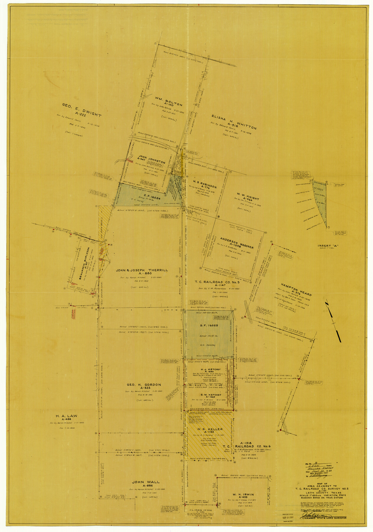
Leon County Rolled Sketch 9
Map of area adjacent to T.C. Railroad Co. survey no. 5, A-1147, Leon County, Texas
-
Map/Doc
9430
-
Collection
General Map Collection
-
Object Dates
1960/9/22 (Creation Date)
1960/9/30 (File Date)
1960/9/14 (Survey Date)
-
People and Organizations
John Cowan (Surveyor/Engineer)
-
Counties
Leon
-
Subjects
Surveying Rolled Sketch
-
Height x Width
50.1 x 35.2 inches
127.3 x 89.4 cm
-
Medium
van dyke/brownline/sepia
-
Scale
1" = 200 varas
Part of: General Map Collection
Crane County Working Sketch 4

Print $20.00
- Digital $50.00
Crane County Working Sketch 4
Size 24.5 x 18.2 inches
Map/Doc 68281
Flight Mission No. BRA-7M, Frame 37, Jefferson County

Print $20.00
- Digital $50.00
Flight Mission No. BRA-7M, Frame 37, Jefferson County
1953
Size 18.7 x 22.4 inches
Map/Doc 85488
Midland County Working Sketch 29

Print $40.00
- Digital $50.00
Midland County Working Sketch 29
1971
Size 49.4 x 35.6 inches
Map/Doc 71010
South Montgomery County, Woodlands Chamber of Commerce Street Map

South Montgomery County, Woodlands Chamber of Commerce Street Map
Size 50.0 x 37.9 inches
Map/Doc 94363
Wichita County Rolled Sketch 9A

Print $20.00
- Digital $50.00
Wichita County Rolled Sketch 9A
1917
Size 32.4 x 27.9 inches
Map/Doc 8247
Atascosa County Working Sketch 7

Print $3.00
- Digital $50.00
Atascosa County Working Sketch 7
1913
Size 14.0 x 9.4 inches
Map/Doc 67203
Pecos County Rolled Sketch 72

Print $30.00
- Digital $50.00
Pecos County Rolled Sketch 72
1934
Size 35.8 x 45.1 inches
Map/Doc 9704
Flight Mission No. CUG-1P, Frame 71, Kleberg County

Print $20.00
- Digital $50.00
Flight Mission No. CUG-1P, Frame 71, Kleberg County
1956
Size 18.5 x 22.2 inches
Map/Doc 86136
Cameron County Rolled Sketch 22

Print $63.00
- Digital $50.00
Cameron County Rolled Sketch 22
Size 9.8 x 15.0 inches
Map/Doc 43919

Flight Mission No. DQN-7K, Frame 95, Calhoun County

Print $20.00
- Digital $50.00
Flight Mission No. DQN-7K, Frame 95, Calhoun County
1953
Size 18.6 x 22.1 inches
Map/Doc 84486
Lamb County Rolled Sketch 9

Print $20.00
- Digital $50.00
Lamb County Rolled Sketch 9
Size 44.7 x 27.9 inches
Map/Doc 9417
You may also like
Carson County Working Sketch 5

Print $20.00
- Digital $50.00
Carson County Working Sketch 5
1979
Size 42.2 x 14.5 inches
Map/Doc 67876
Hardin County Sketch File 2

Print $7.00
- Digital $50.00
Hardin County Sketch File 2
Size 12.7 x 8.4 inches
Map/Doc 25083
San Angelo/Big Spring, Texas Street Map "A Traveler's Best Friend"

San Angelo/Big Spring, Texas Street Map "A Traveler's Best Friend"
Size 37.6 x 25.0 inches
Map/Doc 94400
Hall County Sketch File 9

Print $12.00
- Digital $50.00
Hall County Sketch File 9
Size 14.3 x 8.9 inches
Map/Doc 24802
G. C. & S. F. Ry. Alinement [sic] and Right of Way Map of Dallas Branch, Johnson County, Texas
![64650, G. C. & S. F. Ry. Alinement [sic] and Right of Way Map of Dallas Branch, Johnson County, Texas, General Map Collection](https://historictexasmaps.com/wmedia_w700/maps/64650.tif.jpg)
Print $40.00
- Digital $50.00
G. C. & S. F. Ry. Alinement [sic] and Right of Way Map of Dallas Branch, Johnson County, Texas
1925
Size 38.0 x 125.2 inches
Map/Doc 64650
Floyd County Working Sketch 10

Print $20.00
- Digital $50.00
Floyd County Working Sketch 10
1916
Size 15.4 x 27.3 inches
Map/Doc 69189
Harris County Working Sketch 95

Print $20.00
- Digital $50.00
Harris County Working Sketch 95
1978
Size 26.6 x 44.1 inches
Map/Doc 65987
[Gulf Coast of Texas]
![72701, [Gulf Coast of Texas], General Map Collection](https://historictexasmaps.com/wmedia_w700/maps/72701.tif.jpg)
Print $20.00
- Digital $50.00
[Gulf Coast of Texas]
1881
Size 18.2 x 28.5 inches
Map/Doc 72701
Working Sketch in Crockett County

Print $20.00
- Digital $50.00
Working Sketch in Crockett County
1927
Size 25.6 x 22.7 inches
Map/Doc 90304
[I. & G. N. Block 1]
![91592, [I. & G. N. Block 1], Twichell Survey Records](https://historictexasmaps.com/wmedia_w700/maps/91592-1.tif.jpg)
Print $20.00
- Digital $50.00
[I. & G. N. Block 1]
Size 17.2 x 18.1 inches
Map/Doc 91592
Nueces County Rolled Sketch 55

Print $20.00
- Digital $50.00
Nueces County Rolled Sketch 55
1978
Size 25.7 x 37.5 inches
Map/Doc 6892
Flight Mission No. BRA-6M, Frame 96, Jefferson County

Print $20.00
- Digital $50.00
Flight Mission No. BRA-6M, Frame 96, Jefferson County
1953
Size 18.5 x 22.3 inches
Map/Doc 85439