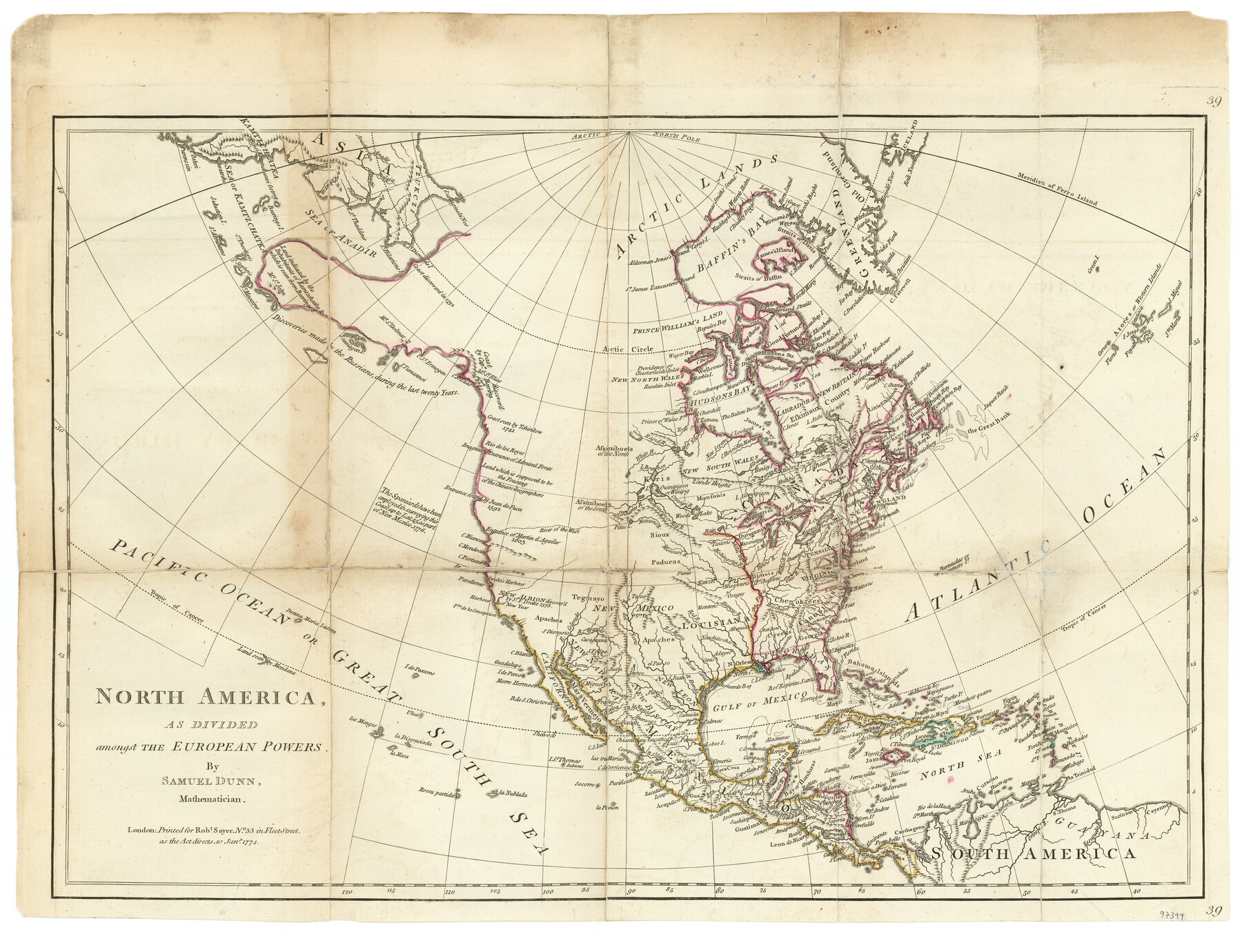
North America, as divided amongst the European Powers
-
Map/Doc
97399
-
Collection
General Map Collection
-
Object Dates
1/10/1774 (Creation Date)
-
People and Organizations
Samuel Dunn (Cartographer)
-
Subjects
North America
-
Height x Width
14.1 x 18.7 inches
35.8 x 47.5 cm
-
Comments
This map appeared in "The American Military Pocket Atlas; being an approved Collection of Correct Maps, both general and particular, of the British Colonies; Especially those which now are, or probably may be the Theatre of War" (97398)
Related maps
The American Military Pocket Atlas; being an approved Collection of Correct Maps, both general and particular, of the British Colonies; Especially those which now are, or probably may be the Theatre of War

The American Military Pocket Atlas; being an approved Collection of Correct Maps, both general and particular, of the British Colonies; Especially those which now are, or probably may be the Theatre of War
1776
Map/Doc 97398
A Compleat Map of the West Indies, containing the Coasts of Florida, Louisiana, New Spain, and Terra Firma: with all the Islands

Print $20.00
- Digital $50.00
A Compleat Map of the West Indies, containing the Coasts of Florida, Louisiana, New Spain, and Terra Firma: with all the Islands
1774
Size 13.9 x 19.0 inches
Map/Doc 97400
A General Map of the Northern British Colonies in America which comprehends the Province of Quebec, the Government of Newfoundland, Nova-Scotia, New England and New York

Print $20.00
- Digital $50.00
A General Map of the Northern British Colonies in America which comprehends the Province of Quebec, the Government of Newfoundland, Nova-Scotia, New England and New York
1776
Size 21.3 x 27.3 inches
Map/Doc 97401
A General Map of the Middle British Colonies, in America. containing Virginia, Maryland, the Delaware Counties, Pennsylvania and New Jersey. With the addition of New York and of the Greatest Part of New England

Print $20.00
- Digital $50.00
A General Map of the Middle British Colonies, in America. containing Virginia, Maryland, the Delaware Counties, Pennsylvania and New Jersey. With the addition of New York and of the Greatest Part of New England
1776
Size 21.6 x 27.2 inches
Map/Doc 97402
A General Map of the Southern British Colonies, in America. comprehending North and South Carolina, Georgia, East and West Florida, with the Neighbouring Indian Countries

Print $20.00
- Digital $50.00
A General Map of the Southern British Colonies, in America. comprehending North and South Carolina, Georgia, East and West Florida, with the Neighbouring Indian Countries
1776
Size 21.3 x 26.4 inches
Map/Doc 97403
A Survey of Lake Champlain, including Lake George, Crown Point and St. John

Print $20.00
- Digital $50.00
A Survey of Lake Champlain, including Lake George, Crown Point and St. John
1762
Size 29.0 x 20.9 inches
Map/Doc 97404
Part of: General Map Collection
Van Zandt County Sketch File 19

Print $4.00
- Digital $50.00
Van Zandt County Sketch File 19
1858
Size 9.7 x 7.7 inches
Map/Doc 39422
United States - Gulf Coast - Galveston to Rio Grande

Print $20.00
- Digital $50.00
United States - Gulf Coast - Galveston to Rio Grande
1941
Size 26.7 x 18.5 inches
Map/Doc 72751
Goliad County Sketch File 41a

Print $4.00
- Digital $50.00
Goliad County Sketch File 41a
1958
Size 11.3 x 8.8 inches
Map/Doc 24347
Webb County Sketch File 11

Print $18.00
- Digital $50.00
Webb County Sketch File 11
1883
Size 8.7 x 7.6 inches
Map/Doc 39770
Flight Mission No. DAG-17K, Frame 62, Matagorda County

Print $20.00
- Digital $50.00
Flight Mission No. DAG-17K, Frame 62, Matagorda County
1952
Size 16.4 x 16.4 inches
Map/Doc 86324
Map of Newton Co.

Print $20.00
- Digital $50.00
Map of Newton Co.
1918
Size 46.4 x 39.4 inches
Map/Doc 81987
Hall County Sketch File 31

Print $8.00
- Digital $50.00
Hall County Sketch File 31
1951
Size 14.3 x 8.9 inches
Map/Doc 24835
Webb County Sketch File 2 and 2A

Print $20.00
- Digital $50.00
Webb County Sketch File 2 and 2A
Size 39.8 x 29.6 inches
Map/Doc 10428
La Salle County Working Sketch Graphic Index

Print $40.00
- Digital $50.00
La Salle County Working Sketch Graphic Index
1923
Size 48.2 x 42.0 inches
Map/Doc 76615
Matagorda County Working Sketch 7

Print $20.00
- Digital $50.00
Matagorda County Working Sketch 7
1953
Size 41.0 x 31.8 inches
Map/Doc 70865
Ward County Rolled Sketch 22

Print $40.00
- Digital $50.00
Ward County Rolled Sketch 22
1873
Size 69.2 x 18.0 inches
Map/Doc 10110
Packery Channel

Print $20.00
- Digital $50.00
Packery Channel
1958
Size 21.1 x 24.3 inches
Map/Doc 3007
You may also like
Jeff Davis County Rolled Sketch T4

Print $20.00
- Digital $50.00
Jeff Davis County Rolled Sketch T4
Size 28.9 x 23.9 inches
Map/Doc 6382
Marion County Working Sketch 38

Print $20.00
- Digital $50.00
Marion County Working Sketch 38
1991
Size 35.5 x 39.9 inches
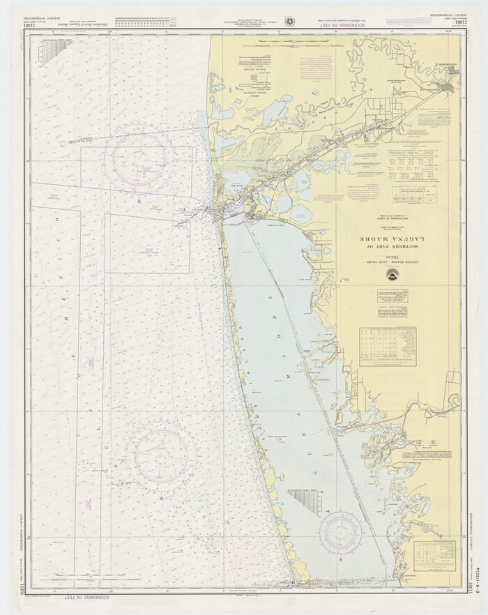
Map/Doc 70814
Southern Part of Laguna Madre
Print $20.00
- Digital $50.00
Southern Part of Laguna Madre
1975
Size 44.8 x 35.5 inches
Map/Doc 73544
Zavala County Sketch File 49

Print $10.00
- Digital $50.00
Zavala County Sketch File 49
1955
Size 14.5 x 9.1 inches
Map/Doc 41441
Hopkins County

Print $20.00
- Digital $50.00
Hopkins County
1942
Size 44.1 x 40.9 inches
Map/Doc 73183
Outer Continental Shelf Leasing Maps (Texas Offshore Operations)

Print $20.00
- Digital $50.00
Outer Continental Shelf Leasing Maps (Texas Offshore Operations)
Size 17.3 x 16.7 inches
Map/Doc 75841

Sketch in Crockett County [UT Blk. 31, 32, 46, 51, Blks. UV, ST, QR, MN]
![89677, Sketch in Crockett County [UT Blk. 31, 32, 46, 51, Blks. UV, ST, QR, MN], Twichell Survey Records](https://historictexasmaps.com/wmedia_w700/maps/89677-1.tif.jpg)
Print $40.00
- Digital $50.00
Sketch in Crockett County [UT Blk. 31, 32, 46, 51, Blks. UV, ST, QR, MN]
1913
Size 33.7 x 48.0 inches
Map/Doc 89677
Coryell County Working Sketch 15

Print $20.00
- Digital $50.00
Coryell County Working Sketch 15
1957
Size 24.3 x 20.8 inches
Map/Doc 68222
Stonewall County Sketch File 7

Print $24.00
- Digital $50.00
Stonewall County Sketch File 7
1896
Size 11.4 x 7.4 inches
Map/Doc 37213
[D. & S. E. Surs., G. C. & S. F. Blk. 9 west of University Land Blks. 49 and 50]
![90308, [D. & S. E. Surs., G. C. & S. F. Blk. 9 west of University Land Blks. 49 and 50], Twichell Survey Records](https://historictexasmaps.com/wmedia_w700/maps/90308-1.tif.jpg)
Print $3.00
- Digital $50.00
[D. & S. E. Surs., G. C. & S. F. Blk. 9 west of University Land Blks. 49 and 50]
Size 11.3 x 15.4 inches
Map/Doc 90308
General Highway Map, Concho County, Texas

Print $20.00
- Digital $50.00
General Highway Map, Concho County, Texas
1954
Size 18.7 x 25.8 inches
Map/Doc 92551