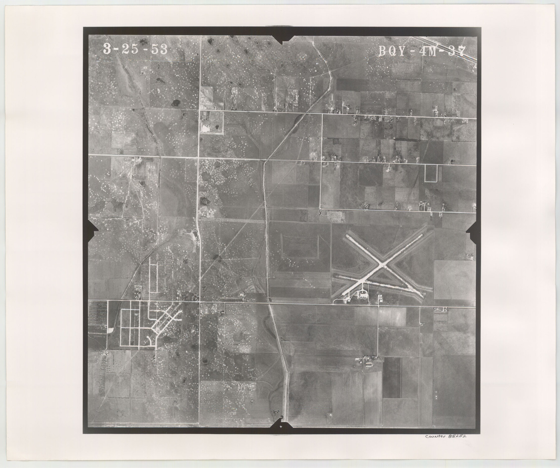
Flight Mission No. BQY-4M, Frame 37, Harris County
BQY-4M-37
-
Map/Doc
85252
-
Collection
General Map Collection
-
Object Dates
1953/3/25 (Creation Date)
-
People and Organizations
U. S. Department of Agriculture (Publisher)
-
Counties
Harris
-
Subjects
Aerial Photograph
-
Height x Width
18.6 x 22.3 inches
47.2 x 56.6 cm
-
Comments
Flown by Jack Ammann Photogrammetric Engineers of San Antonio, Texas.
Part of: General Map Collection
Kimble County Working Sketch 15

Print $20.00
- Digital $50.00
Kimble County Working Sketch 15
1923
Size 22.4 x 22.1 inches
Map/Doc 70083
Aransas County Rolled Sketch 6

Print $20.00
- Digital $50.00
Aransas County Rolled Sketch 6
1953
Size 19.6 x 18.8 inches
Map/Doc 77190
Maverick County Sketch File 8

Print $8.00
- Digital $50.00
Maverick County Sketch File 8
1878
Size 11.5 x 6.5 inches
Map/Doc 31064
Hardin County Sketch File 37

Print $20.00
- Digital $50.00
Hardin County Sketch File 37
Size 20.4 x 17.7 inches
Map/Doc 11633
Copy of Surveyor's Field Book, Morris Browning - In Blocks 7, 5 & 4, I&GNRRCo., Hutchinson and Carson Counties, Texas

Print $2.00
- Digital $50.00
Copy of Surveyor's Field Book, Morris Browning - In Blocks 7, 5 & 4, I&GNRRCo., Hutchinson and Carson Counties, Texas
1888
Size 7.0 x 8.8 inches
Map/Doc 62270
Brewster County Rolled Sketch 60

Print $20.00
- Digital $50.00
Brewster County Rolled Sketch 60
Size 24.8 x 36.5 inches
Map/Doc 61783
Brewster County Sketch File 20

Print $40.00
- Digital $50.00
Brewster County Sketch File 20
1946
Size 19.1 x 15.2 inches
Map/Doc 10979
Presidio County Rolled Sketch D2

Print $20.00
- Digital $50.00
Presidio County Rolled Sketch D2
1908
Size 14.3 x 16.9 inches
Map/Doc 7410
Real County Working Sketch 24

Print $20.00
- Digital $50.00
Real County Working Sketch 24
1946
Size 17.4 x 22.5 inches
Map/Doc 71916
Kerr County Sketch File 6

Print $20.00
- Digital $50.00
Kerr County Sketch File 6
1879
Size 16.4 x 22.4 inches
Map/Doc 11917
[Three-Marine League line stipulation as determined by US Supreme Court, October 1968 term; corrections to stipulation; Texas GLO approximations of county areas embraced by county boundaries, shoreline and 3-marine league line and 3-mile line]

Print $64.00
[Three-Marine League line stipulation as determined by US Supreme Court, October 1968 term; corrections to stipulation; Texas GLO approximations of county areas embraced by county boundaries, shoreline and 3-marine league line and 3-mile line]
1962
Size 13.4 x 8.7 inches
Map/Doc 61371
Knox County Boundary File 3

Print $54.00
- Digital $50.00
Knox County Boundary File 3
Size 8.9 x 7.7 inches
Map/Doc 65019
You may also like
Flight Mission No. CUG-1P, Frame 167, Kleberg County

Print $20.00
- Digital $50.00
Flight Mission No. CUG-1P, Frame 167, Kleberg County
1956
Size 18.7 x 22.4 inches
Map/Doc 86174
Dimmit County Sketch File 19

Print $28.00
- Digital $50.00
Dimmit County Sketch File 19
1886
Size 13.4 x 8.8 inches
Map/Doc 21088
Flight Mission No. CRK-3P, Frame 69, Refugio County

Print $20.00
- Digital $50.00
Flight Mission No. CRK-3P, Frame 69, Refugio County
1956
Size 18.5 x 22.2 inches
Map/Doc 86911
Block 39 of the Brown Subdivision being a part of the Northeast Quarter Section 4, Block O

Print $20.00
- Digital $50.00
Block 39 of the Brown Subdivision being a part of the Northeast Quarter Section 4, Block O
1954
Size 14.8 x 14.2 inches
Map/Doc 92822
Pecos County Working Sketch 47

Print $20.00
- Digital $50.00
Pecos County Working Sketch 47
1947
Size 19.2 x 21.9 inches
Map/Doc 71519
Falls County Sketch File 17

Print $6.00
- Digital $50.00
Falls County Sketch File 17
1872
Size 8.4 x 13.1 inches
Map/Doc 22377
[North Central Part of County]
![90812, [North Central Part of County], Twichell Survey Records](https://historictexasmaps.com/wmedia_w700/maps/90812-2.tif.jpg)
Print $20.00
- Digital $50.00
[North Central Part of County]
1902
Size 21.0 x 28.3 inches
Map/Doc 90812
General Highway Map, Walker County, Texas

Print $20.00
General Highway Map, Walker County, Texas
1961
Size 24.7 x 18.1 inches
Map/Doc 79698
Limestone County Working Sketch 16

Print $40.00
- Digital $50.00
Limestone County Working Sketch 16
1951
Size 55.7 x 27.8 inches
Map/Doc 70566
Map of Wilbarger County

Print $40.00
- Digital $50.00
Map of Wilbarger County
1887
Size 52.2 x 47.0 inches
Map/Doc 16926
West Part Presidio Co.

Print $20.00
- Digital $50.00
West Part Presidio Co.
1974
Size 43.2 x 34.3 inches
Map/Doc 95618
Red River County Working Sketch 48

Print $20.00
- Digital $50.00
Red River County Working Sketch 48
1970
Size 28.6 x 30.2 inches
Map/Doc 72031