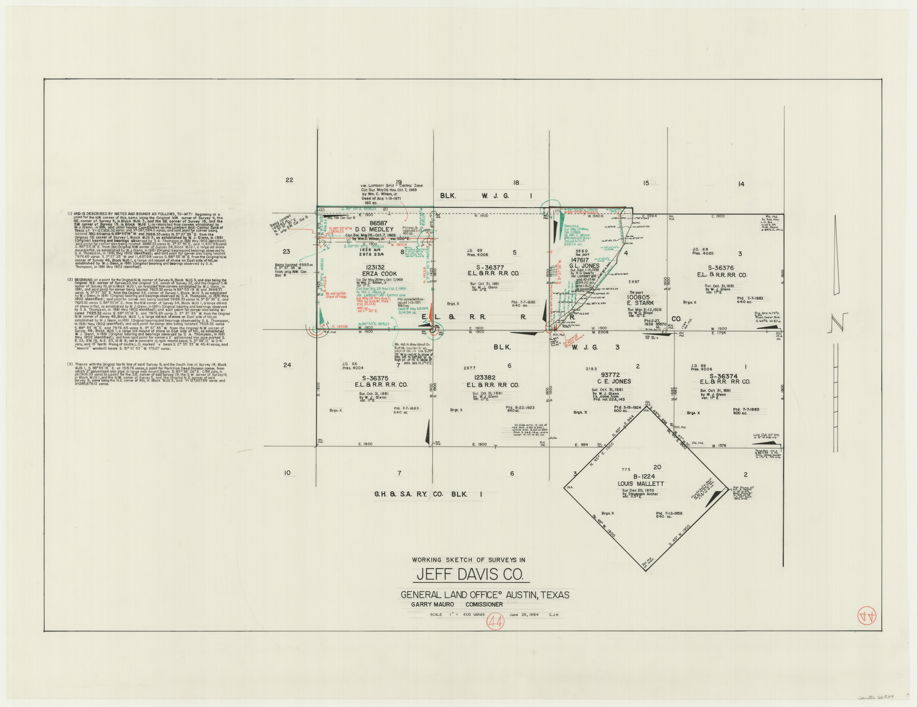
Jeff Davis County Working Sketch 44
-
Map/Doc
66539
-
Collection
General Map Collection
-
Object Dates
6/25/1984 (Creation Date)
-
People and Organizations
Huffman, Cynthia J. (Draftsman)
-
Counties
Jeff Davis
-
Subjects
Surveying Working Sketch
-
Height x Width
28.8 x 37.4 inches
73.2 x 95.0 cm
-
Scale
1" = 400 varas
Part of: General Map Collection
Marion County Working Sketch 40

Print $20.00
- Digital $50.00
Marion County Working Sketch 40
1992
Size 42.9 x 30.0 inches
Map/Doc 70816
Amistad International Reservoir on Rio Grande 78a

Print $20.00
- Digital $50.00
Amistad International Reservoir on Rio Grande 78a
1949
Size 28.5 x 40.1 inches
Map/Doc 75507
Flight Mission No. DQN-1K, Frame 70, Calhoun County

Print $20.00
- Digital $50.00
Flight Mission No. DQN-1K, Frame 70, Calhoun County
1953
Size 18.6 x 22.3 inches
Map/Doc 84157
Cass County Sketch File 17

Print $4.00
- Digital $50.00
Cass County Sketch File 17
Size 8.2 x 10.2 inches
Map/Doc 17418
Flight Mission No. BQR-20K, Frame 7, Brazoria County

Print $20.00
- Digital $50.00
Flight Mission No. BQR-20K, Frame 7, Brazoria County
1952
Size 18.6 x 22.4 inches
Map/Doc 84109
Uvalde County Working Sketch 11

Print $20.00
- Digital $50.00
Uvalde County Working Sketch 11
1943
Size 17.6 x 16.6 inches
Map/Doc 72081
Galveston County Rolled Sketch 45B

Print $20.00
- Digital $50.00
Galveston County Rolled Sketch 45B
1995
Size 19.8 x 29.7 inches
Map/Doc 5980
Terrell County Rolled Sketch 24

Print $20.00
- Digital $50.00
Terrell County Rolled Sketch 24
Size 19.7 x 25.7 inches
Map/Doc 7931
Hutchinson County Boundary File 2

Print $2.00
- Digital $50.00
Hutchinson County Boundary File 2
Size 11.2 x 8.8 inches
Map/Doc 55302
Johnson County Sketch File 14

Print $4.00
- Digital $50.00
Johnson County Sketch File 14
1860
Size 12.8 x 8.2 inches
Map/Doc 28450
Real County Working Sketch 73

Print $20.00
- Digital $50.00
Real County Working Sketch 73
1978
Size 28.2 x 24.9 inches
Map/Doc 71965
Jefferson County Sketch File 12

Print $63.00
- Digital $50.00
Jefferson County Sketch File 12
Size 8.8 x 7.5 inches
Map/Doc 28135
You may also like
Hardin County Sketch File 29

Print $4.00
- Digital $50.00
Hardin County Sketch File 29
Size 8.1 x 11.8 inches
Map/Doc 25155
Nueces County Rolled Sketch 98B

Print $20.00
- Digital $50.00
Nueces County Rolled Sketch 98B
Size 33.5 x 32.7 inches
Map/Doc 9632
Panola County Working Sketch 27

Print $20.00
- Digital $50.00
Panola County Working Sketch 27
1956
Map/Doc 71436
Val Verde County Sketch File A4

Print $10.00
- Digital $50.00
Val Verde County Sketch File A4
1897
Size 9.2 x 8.5 inches
Map/Doc 39046
A sketch of surveys made on the coast east of Bolivar Point

Print $20.00
- Digital $50.00
A sketch of surveys made on the coast east of Bolivar Point
1841
Size 9.1 x 22.0 inches
Map/Doc 22
Reeves County Working Sketch 65

Print $20.00
- Digital $50.00
Reeves County Working Sketch 65
1990
Size 17.3 x 19.7 inches
Map/Doc 63508
"The Texas and Pacific Railway Company Reservation and Land Grant"

Print $38.00
- Digital $50.00
"The Texas and Pacific Railway Company Reservation and Land Grant"
1962
Size 9.3 x 6.5 inches
Map/Doc 62213
Gray's New Map of Texas and the Indian Territory

Print $20.00
- Digital $50.00
Gray's New Map of Texas and the Indian Territory
1876
Size 17.4 x 27.7 inches
Map/Doc 93786
Childress County

Print $20.00
- Digital $50.00
Childress County
1883
Size 20.8 x 19.0 inches
Map/Doc 3394
Howard County State Real Property Sketch 1

Print $40.00
- Digital $50.00
Howard County State Real Property Sketch 1
2007
Size 24.3 x 35.2 inches
Map/Doc 88673
[Surveying Sketch of Jesse McGee, Jas McKim, W. S. Kennard, et al in Sabine and Newton Counties, Texas]
![5066, [Surveying Sketch of Jesse McGee, Jas McKim, W. S. Kennard, et al in Sabine and Newton Counties, Texas], Maddox Collection](https://historictexasmaps.com/wmedia_w700/maps/5066.tif.jpg)
Print $20.00
- Digital $50.00
[Surveying Sketch of Jesse McGee, Jas McKim, W. S. Kennard, et al in Sabine and Newton Counties, Texas]
1916
Size 32.0 x 37.5 inches
Map/Doc 5066
El Paso County Working Sketch 25

Print $20.00
- Digital $50.00
El Paso County Working Sketch 25
1962
Size 42.7 x 41.9 inches
Map/Doc 69047