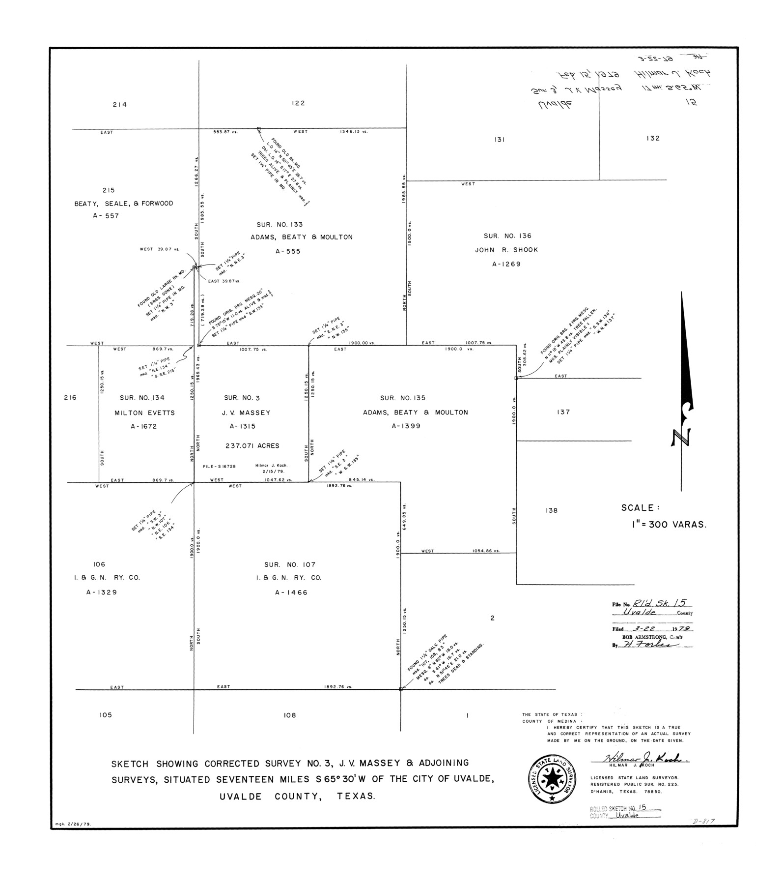
Uvalde County Rolled Sketch 15
Sketch showing corrected survey no. 3, J.V. Massey & adjoining surveys
-
Map/Doc
8099
-
Collection
General Map Collection
-
Object Dates
1979/2/15 (Creation Date)
1979/3/22 (File Date)
-
People and Organizations
Hilmar J. Koch (Surveyor/Engineer)
-
Counties
Uvalde
-
Subjects
Surveying Rolled Sketch
-
Height x Width
26.9 x 23.9 inches
68.3 x 60.7 cm
-
Medium
mylar, print
-
Scale
1" = 300 varas
Part of: General Map Collection
Throckmorton County Sketch File 6

Print $27.00
- Digital $50.00
Throckmorton County Sketch File 6
1888
Size 9.0 x 6.9 inches
Map/Doc 38076
Wilbarger County Working Sketch 8

Print $20.00
- Digital $50.00
Wilbarger County Working Sketch 8
1948
Size 31.8 x 38.2 inches
Map/Doc 72546
A Map of the Indian Territory, Northern Texas and New Mexico Showing the Great Western Prairies

Print $20.00
- Digital $50.00
A Map of the Indian Territory, Northern Texas and New Mexico Showing the Great Western Prairies
1844
Size 14.0 x 17.6 inches
Map/Doc 95700
Kinney County Rolled Sketch 19

Print $20.00
- Digital $50.00
Kinney County Rolled Sketch 19
1978
Size 20.7 x 16.8 inches
Map/Doc 6546
[Map of Parker County]
![3941, [Map of Parker County], General Map Collection](https://historictexasmaps.com/wmedia_w700/maps/3941.tif.jpg)
Print $20.00
- Digital $50.00
[Map of Parker County]
Size 22.0 x 34.0 inches
Map/Doc 3941
Blanco County Sketch File 12

Print $20.00
- Digital $50.00
Blanco County Sketch File 12
Size 15.0 x 19.8 inches
Map/Doc 10928
Freestone County Sketch File 14a

Print $6.00
- Digital $50.00
Freestone County Sketch File 14a
1861
Size 5.3 x 5.9 inches
Map/Doc 23067
Blanco County Working Sketch 36

Print $20.00
- Digital $50.00
Blanco County Working Sketch 36
1979
Size 23.8 x 22.0 inches
Map/Doc 67396
Wichita County Sketch File 16a

Print $4.00
- Digital $50.00
Wichita County Sketch File 16a
Size 14.2 x 8.7 inches
Map/Doc 40097
Chambers County Rolled Sketch 24

Print $40.00
- Digital $50.00
Chambers County Rolled Sketch 24
1940
Size 38.2 x 49.9 inches
Map/Doc 8594
Carte des Côtes du Golfe du Mexique compris entre la Pointe Sud de la Presqu'Ile de la Floride et la Pointe Nord de la Presqu'Ile d'Yucatan

Print $20.00
- Digital $50.00
Carte des Côtes du Golfe du Mexique compris entre la Pointe Sud de la Presqu'Ile de la Floride et la Pointe Nord de la Presqu'Ile d'Yucatan
1800
Size 26.0 x 37.5 inches
Map/Doc 95322
Flight Mission No. DAG-26K, Frame 60, Matagorda County

Print $20.00
- Digital $50.00
Flight Mission No. DAG-26K, Frame 60, Matagorda County
1953
Size 18.7 x 22.7 inches
Map/Doc 86580
You may also like
Henderson County Sketch File 18

Print $20.00
- Digital $50.00
Henderson County Sketch File 18
1936
Size 16.7 x 18.3 inches
Map/Doc 11756
Pecos County Rolled Sketch 60

Print $20.00
- Digital $50.00
Pecos County Rolled Sketch 60
1926
Size 18.3 x 24.2 inches
Map/Doc 7232
Presidio County Sketch File 116

Print $86.00
- Digital $50.00
Presidio County Sketch File 116
1993
Size 11.4 x 8.7 inches
Map/Doc 34842
Flight Mission No. BRE-2P, Frame 133, Nueces County

Print $20.00
- Digital $50.00
Flight Mission No. BRE-2P, Frame 133, Nueces County
1956
Size 18.5 x 22.5 inches
Map/Doc 86806
Navigation Maps of Gulf Intracoastal Waterway, Port Arthur to Brownsville, Texas

Print $4.00
- Digital $50.00
Navigation Maps of Gulf Intracoastal Waterway, Port Arthur to Brownsville, Texas
1951
Size 16.6 x 21.5 inches
Map/Doc 65427
Flight Mission No. CUG-1P, Frame 83, Kleberg County

Print $20.00
- Digital $50.00
Flight Mission No. CUG-1P, Frame 83, Kleberg County
1956
Size 18.5 x 22.2 inches
Map/Doc 86148
Montgomery County Working Sketch 18

Print $20.00
- Digital $50.00
Montgomery County Working Sketch 18
1935
Size 34.0 x 39.1 inches
Map/Doc 71125
Atascosa County Rolled Sketch 13

Print $20.00
- Digital $50.00
Atascosa County Rolled Sketch 13
1944
Size 34.8 x 27.7 inches
Map/Doc 5095
Lavaca County Sketch File 2

Print $6.00
- Digital $50.00
Lavaca County Sketch File 2
1849
Size 8.7 x 7.5 inches
Map/Doc 29630
Current Miscellaneous File 61

Print $4.00
- Digital $50.00
Current Miscellaneous File 61
1956
Size 9.3 x 13.6 inches
Map/Doc 74066
Hardeman County Boundary File 4

Print $142.00
- Digital $50.00
Hardeman County Boundary File 4
Size 24.0 x 18.2 inches
Map/Doc 54392
Callahan County Working Sketch 3

Print $20.00
- Digital $50.00
Callahan County Working Sketch 3
1952
Size 35.3 x 30.5 inches
Map/Doc 67885