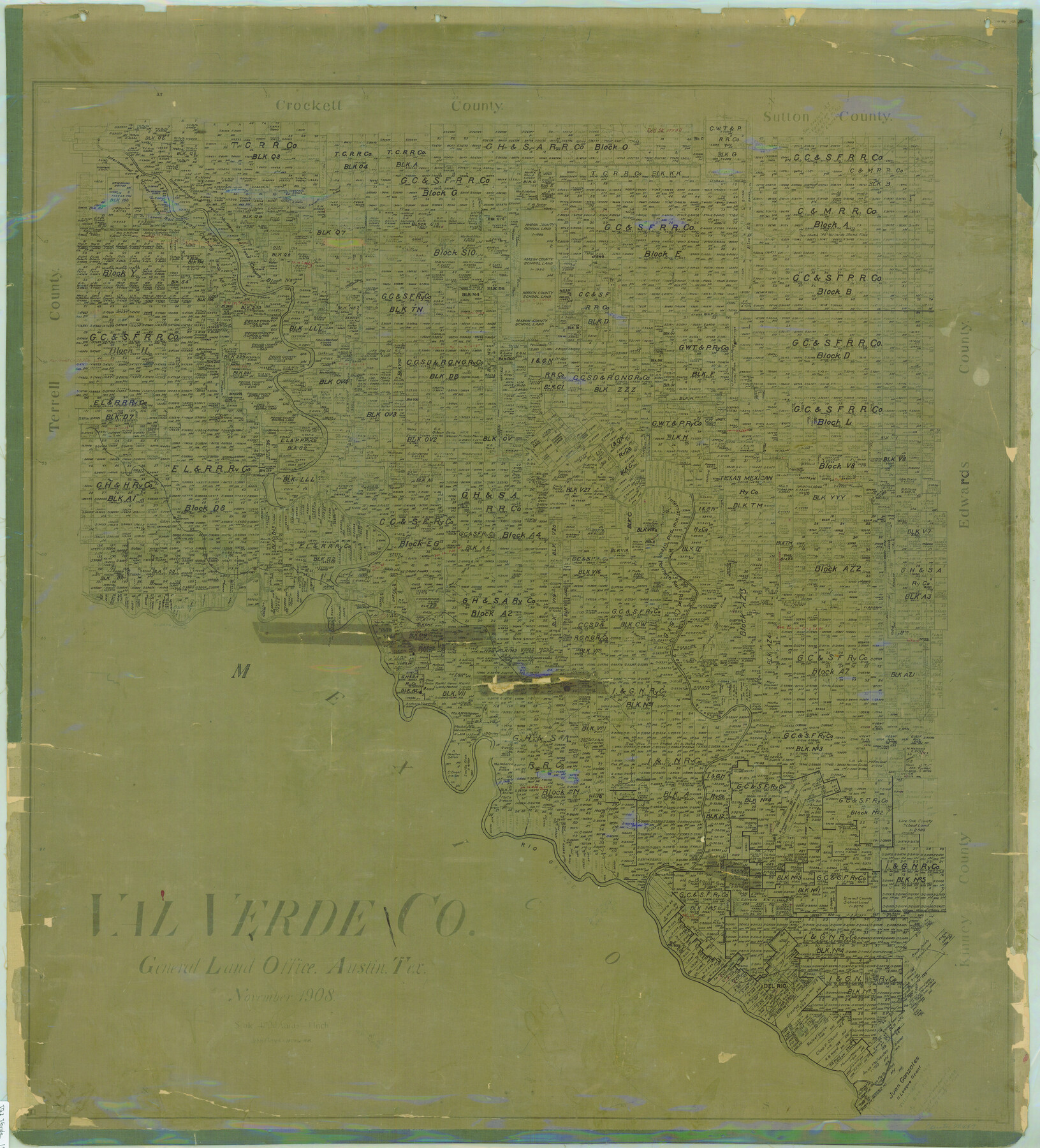
Val Verde Co.
-
Map/Doc
78447
-
Collection
General Map Collection
-
Object Dates
1908 (Creation Date)
-
People and Organizations
Texas General Land Office (Publisher)
S.C. Clark (Draftsman)
S.C. Clark (Compiler)
-
Counties
Val Verde
-
Subjects
County
-
Height x Width
41.2 x 37.3 inches
104.6 x 94.7 cm
-
Comments
Note on back: "Hung June 29th, 1927".
Help Save Texas History - Adopt Me! -
Features
Devil's River
Shumla
Cow Creek
Comstock
Evan's Creek
Rio Grande
McKee
Johnston
Del Rio
Langtry
Feely
Samuels
Juno
Pecos River
Dry Devil's River
Deadmans Creek
Sycamore Creek
Buckleys Creek
Dead Man's Cañon
Devil River
Willow Springs
Osman
Dolan's Creek
Pecan Spring
Blue Hills
Beaver Lake
Dry Creek
Lowe's Creek
Bandera Road
China Creek
Fielders Creek
Col. Shafter's Trail
North Prong of Buckley's Creek
Part of: General Map Collection
Texas 1971 Official State Highway Map

Digital $50.00
Texas 1971 Official State Highway Map
Size 27.9 x 36.3 inches
Map/Doc 94315
Zavala County Sketch File 35

Print $4.00
- Digital $50.00
Zavala County Sketch File 35
1887
Size 11.3 x 9.0 inches
Map/Doc 41397
[Rosebud Station Map - Tracks and Structures - Lands, San Antonio and Aransas Pass Railway Co.]
![62566, [Rosebud Station Map - Tracks and Structures - Lands, San Antonio and Aransas Pass Railway Co.], General Map Collection](https://historictexasmaps.com/wmedia_w700/maps/62566.tif.jpg)
Print $4.00
- Digital $50.00
[Rosebud Station Map - Tracks and Structures - Lands, San Antonio and Aransas Pass Railway Co.]
1919
Size 11.7 x 18.6 inches
Map/Doc 62566
Starr County Boundary File 2

Print $8.00
- Digital $50.00
Starr County Boundary File 2
Size 11.0 x 7.4 inches
Map/Doc 58814
La Salle County Working Sketch 48

Print $20.00
- Digital $50.00
La Salle County Working Sketch 48
1983
Size 26.2 x 36.0 inches
Map/Doc 70349
[Cotton Belt, St. Louis Southwestern Railway of Texas, Alignment through Smith County]
![64375, [Cotton Belt, St. Louis Southwestern Railway of Texas, Alignment through Smith County], General Map Collection](https://historictexasmaps.com/wmedia_w700/maps/64375.tif.jpg)
Print $20.00
- Digital $50.00
[Cotton Belt, St. Louis Southwestern Railway of Texas, Alignment through Smith County]
1903
Size 21.3 x 28.5 inches
Map/Doc 64375
Flight Mission No. BQY-4M, Frame 120, Harris County

Print $20.00
- Digital $50.00
Flight Mission No. BQY-4M, Frame 120, Harris County
1953
Size 18.5 x 22.3 inches
Map/Doc 85288
Map of Terry County

Print $20.00
- Digital $50.00
Map of Terry County
1893
Size 27.4 x 23.3 inches
Map/Doc 4076
Newton County Sketch File 19

Print $20.00
- Digital $50.00
Newton County Sketch File 19
Size 22.8 x 9.4 inches
Map/Doc 42158
Presidio County Sketch File U

Print $10.00
- Digital $50.00
Presidio County Sketch File U
1914
Size 10.2 x 8.2 inches
Map/Doc 34544
Hardin County Sketch File 35

Print $24.00
- Digital $50.00
Hardin County Sketch File 35
Size 9.2 x 8.4 inches
Map/Doc 25175
Webb County Sketch File 54

Print $46.00
- Digital $50.00
Webb County Sketch File 54
1939
Size 11.3 x 8.8 inches
Map/Doc 39841
You may also like

Flight Mission No. DQO-8K, Frame 112, Galveston County

Print $20.00
- Digital $50.00
Flight Mission No. DQO-8K, Frame 112, Galveston County
1952
Size 18.6 x 22.4 inches
Map/Doc 85194
Flight Mission No. DAG-21K, Frame 87, Matagorda County

Print $20.00
- Digital $50.00
Flight Mission No. DAG-21K, Frame 87, Matagorda County
1952
Size 18.5 x 22.4 inches
Map/Doc 86416
Newton County Rolled Sketch 27A

Print $20.00
- Digital $50.00
Newton County Rolled Sketch 27A
1961
Size 35.9 x 27.1 inches
Map/Doc 6857
Bell County Working Sketch 6

Print $20.00
- Digital $50.00
Bell County Working Sketch 6
1946
Size 24.9 x 33.6 inches
Map/Doc 67346
Palo Pinto County Rolled Sketch 4

Print $20.00
- Digital $50.00
Palo Pinto County Rolled Sketch 4
Size 15.9 x 23.2 inches
Map/Doc 7189
The Texas and Pacific Ry. Co., Station Map, Roscoe, Texas

Print $20.00
- Digital $50.00
The Texas and Pacific Ry. Co., Station Map, Roscoe, Texas
Size 11.0 x 19.0 inches
Map/Doc 64690
Maps & Lists Showing Prison Lands (Oil & Gas) Leased as of June 1955

Print $2.00
- Digital $50.00
Maps & Lists Showing Prison Lands (Oil & Gas) Leased as of June 1955
1955
Size 11.2 x 8.8 inches
Map/Doc 62863
Crane County Sketch File 1

Print $20.00
- Digital $50.00
Crane County Sketch File 1
Size 44.8 x 14.6 inches
Map/Doc 10343
Bandera County Sketch File 5

Print $4.00
- Digital $50.00
Bandera County Sketch File 5
Size 8.6 x 6.8 inches
Map/Doc 14003
Presidio County Working Sketch 103

Print $20.00
- Digital $50.00
Presidio County Working Sketch 103
1980
Size 47.8 x 31.2 inches
Map/Doc 71780
Flight Mission No. BRA-7M, Frame 208, Jefferson County

Print $20.00
- Digital $50.00
Flight Mission No. BRA-7M, Frame 208, Jefferson County
1953
Size 18.5 x 22.3 inches
Map/Doc 85576