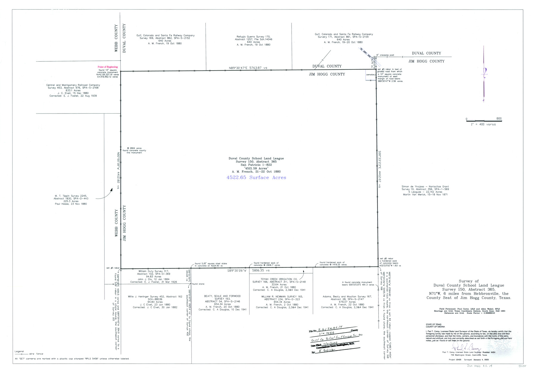
Jim Hogg County Rolled Sketch 14
Survey of Duval County School Land League survey 150, abstract 365
-
Map/Doc
97155
-
Collection
General Map Collection
-
Object Dates
1/4/2023 (Creation Date)
11/1/2023 (File Date)
-
People and Organizations
Paul T. Carey (Surveyor/Engineer)
Allen Walzel (Chainman/Field Personnel)
-
Counties
Jim Hogg
-
Subjects
Surveying Rolled Sketch
-
Height x Width
21.1 x 30.3 inches
53.6 x 77.0 cm
-
Medium
mylar, print
-
Scale
1" = 400 varas
Part of: General Map Collection
Wharton County Working Sketch 25

Print $20.00
- Digital $50.00
Wharton County Working Sketch 25
1993
Size 20.0 x 25.5 inches
Map/Doc 72489
Photo Index of Texas Coast - Sheet 6 of 6

Print $20.00
- Digital $50.00
Photo Index of Texas Coast - Sheet 6 of 6
1954
Size 20.0 x 24.0 inches
Map/Doc 83444
Bell County Boundary File 3a

Print $82.00
- Digital $50.00
Bell County Boundary File 3a
Size 11.2 x 8.5 inches
Map/Doc 50502
Bee County Working Sketch 24

Print $20.00
- Digital $50.00
Bee County Working Sketch 24
1987
Size 36.6 x 24.0 inches
Map/Doc 67274
Schleicher County Working Sketch 20

Print $20.00
- Digital $50.00
Schleicher County Working Sketch 20
1951
Size 33.8 x 21.2 inches
Map/Doc 63822

Rusk County Sketch File 19

Print $4.00
Rusk County Sketch File 19
Size 13.0 x 8.2 inches
Map/Doc 35526
Map of Bastrop District

Print $20.00
- Digital $50.00
Map of Bastrop District
1847
Size 22.9 x 28.3 inches
Map/Doc 3275
Map of the United States and Territories to accompany annual report of Hon. N.C. McFarland, Commissioner, General Land Office for fiscal year which ended June 30, 1884

Print $20.00
- Digital $50.00
Map of the United States and Territories to accompany annual report of Hon. N.C. McFarland, Commissioner, General Land Office for fiscal year which ended June 30, 1884
Size 27.0 x 39.3 inches
Map/Doc 96631
Jefferson County Working Sketch 29

Print $40.00
- Digital $50.00
Jefferson County Working Sketch 29
1977
Size 52.4 x 42.7 inches
Map/Doc 66572
Flight Mission No. DQN-1K, Frame 28, Calhoun County

Print $20.00
- Digital $50.00
Flight Mission No. DQN-1K, Frame 28, Calhoun County
1953
Size 18.5 x 22.3 inches
Map/Doc 84133
Denton County Working Sketch 34

Print $20.00
- Digital $50.00
Denton County Working Sketch 34
2005
Size 22.2 x 27.3 inches
Map/Doc 83570
You may also like
Robertson County Sketch File 10 (1)

Print $3.00
- Digital $50.00
Robertson County Sketch File 10 (1)
Size 13.0 x 10.4 inches
Map/Doc 43369
Flight Mission No. BRE-1P, Frame 55, Nueces County

Print $20.00
- Digital $50.00
Flight Mission No. BRE-1P, Frame 55, Nueces County
1956
Size 18.3 x 22.2 inches
Map/Doc 86644
The Republic County of Bastrop. December 29, 1845

Print $20.00
The Republic County of Bastrop. December 29, 1845
2020
Size 14.8 x 21.7 inches
Map/Doc 96092
Harris County Historic Topographic 4

Print $20.00
- Digital $50.00
Harris County Historic Topographic 4
1916
Size 14.5 x 24.6 inches
Map/Doc 65814
Kent County Sketch File 1

Print $6.00
- Digital $50.00
Kent County Sketch File 1
1882
Size 10.9 x 12.2 inches
Map/Doc 28823
Chambers County Rolled Sketch 7

Print $20.00
- Digital $50.00
Chambers County Rolled Sketch 7
Size 39.8 x 23.1 inches
Map/Doc 8611
Webb County Working Sketch 92

Print $20.00
- Digital $50.00
Webb County Working Sketch 92
1988
Size 30.6 x 37.0 inches
Map/Doc 72459
Flight Mission No. CGI-3N, Frame 78, Cameron County

Print $20.00
- Digital $50.00
Flight Mission No. CGI-3N, Frame 78, Cameron County
1954
Size 18.6 x 22.3 inches
Map/Doc 84572
McCulloch County Working Sketch 12

Print $20.00
- Digital $50.00
McCulloch County Working Sketch 12
1982
Size 37.5 x 20.1 inches
Map/Doc 70687

Right-of-Way and Track Map, Texas State Railroad operated by the T. and N. O. R.R. Co.

Print $40.00
- Digital $50.00
Right-of-Way and Track Map, Texas State Railroad operated by the T. and N. O. R.R. Co.
1917
Size 24.3 x 55.7 inches
Map/Doc 64176
Flight Mission No. BRE-2P, Frame 130, Nueces County

Print $20.00
- Digital $50.00
Flight Mission No. BRE-2P, Frame 130, Nueces County
1956
Size 18.6 x 22.3 inches
Map/Doc 86803