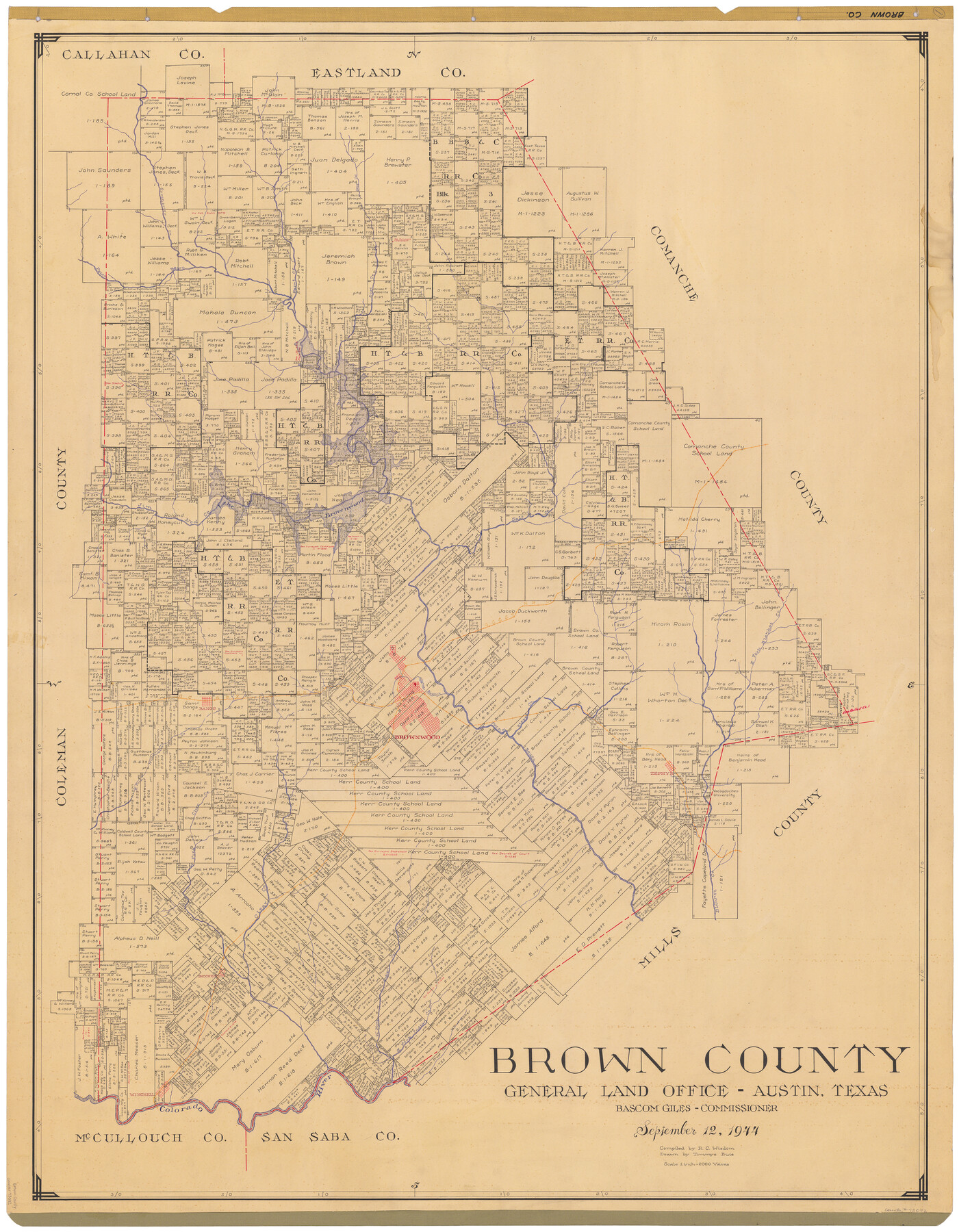
Brown County
-
Map/Doc
73092
-
Collection
General Map Collection
-
Object Dates
1944/9/12 (Creation Date)
-
People and Organizations
Texas General Land Office (Publisher)
Tommye Buie (Draftsman)
Bascom Giles (GLO Commissioner)
R.C. Wisdom (Compiler)
-
Counties
Brown
-
Subjects
County
-
Height x Width
48.5 x 37.6 inches
123.2 x 95.5 cm
-
Comments
Note on reverse side: "Compilation completed September 12, 1944. Inking completed November 27, 1944. Tracing completed January 3, 1945. Placed in official use January 5, 1945. Replaced [on sticks] by copy June 15, 1946."
-
Features
Bangs
Winchell
Colorado River
East Fork of Indian Creek
West Fork of Indian Creek
Brookesmith
Blanket Creek
West Fork of Clear Creek
East Fork of Mukewater Creek
Brownwood
Zephyr
Stepps
Hog Creek
Adams Branch of Pecan Bayou
East Fork of Blanket Creek
GC&SF
Jim Ned Creek
Lake Brownwood
Salt Creek
Pecan Bayou
Paint Creek
Lost Creek
Greenbrier [sic] Creek
Part of: General Map Collection
Ward County Rolled Sketch 22

Print $40.00
- Digital $50.00
Ward County Rolled Sketch 22
1873
Size 69.2 x 18.0 inches
Map/Doc 10110
Hudspeth County Sketch File 11

Print $14.00
- Digital $50.00
Hudspeth County Sketch File 11
Size 14.5 x 8.9 inches
Map/Doc 26903
Donley County Sketch File 1a

Print $20.00
- Digital $50.00
Donley County Sketch File 1a
Size 23.6 x 16.6 inches
Map/Doc 11362
Maps & Lists Showing Prison Lands (Oil & Gas) Leased as of June 1955

Print $2.00
- Digital $50.00
Maps & Lists Showing Prison Lands (Oil & Gas) Leased as of June 1955
1955
Size 11.2 x 8.8 inches
Map/Doc 62863
Archer County Sketch File 7

Print $6.00
- Digital $50.00
Archer County Sketch File 7
Size 8.8 x 11.8 inches
Map/Doc 13636
Hale County Working Sketch 1

Print $20.00
- Digital $50.00
Hale County Working Sketch 1
1910
Size 34.5 x 22.1 inches
Map/Doc 63321
Colorado County Working Sketch 30

Print $20.00
- Digital $50.00
Colorado County Working Sketch 30
1980
Size 22.2 x 19.8 inches
Map/Doc 68130
Comal County Rolled Sketch 5

Print $20.00
- Digital $50.00
Comal County Rolled Sketch 5
1985
Size 30.6 x 26.7 inches
Map/Doc 5540
Texas & Pacific Ry Reserve west of the Pecos River

Print $40.00
- Digital $50.00
Texas & Pacific Ry Reserve west of the Pecos River
1880
Size 43.9 x 90.6 inches
Map/Doc 3047
Reeves County Sketch File 5

Print $20.00
- Digital $50.00
Reeves County Sketch File 5
Size 16.1 x 33.4 inches
Map/Doc 12241
Lampasas County Working Sketch 11

Print $20.00
- Digital $50.00
Lampasas County Working Sketch 11
1964
Size 38.3 x 42.8 inches
Map/Doc 70288
Galveston County Rolled Sketch 30

Print $20.00
- Digital $50.00
Galveston County Rolled Sketch 30
1979
Size 28.0 x 39.8 inches
Map/Doc 5964
You may also like
Flight Mission No. CRC-1R, Frame 34, Chambers County

Print $20.00
- Digital $50.00
Flight Mission No. CRC-1R, Frame 34, Chambers County
1956
Size 18.8 x 22.4 inches
Map/Doc 84702
Lampasas County Working Sketch 10

Print $20.00
- Digital $50.00
Lampasas County Working Sketch 10
1963
Size 32.2 x 42.9 inches
Map/Doc 70287
Chambers County NRC Article 33.136 Sketch 13

Print $22.00
Chambers County NRC Article 33.136 Sketch 13
Size 35.9 x 23.2 inches
Map/Doc 97014
Pecos County Sketch

Print $20.00
- Digital $50.00
Pecos County Sketch
Size 34.2 x 23.2 inches
Map/Doc 92915
[Sections 59-70, I. & G. N. Block 1 and Runnels County School Land League 3]
![91680, [Sections 59-70, I. & G. N. Block 1 and Runnels County School Land League 3], Twichell Survey Records](https://historictexasmaps.com/wmedia_w700/maps/91680-1.tif.jpg)
Print $20.00
- Digital $50.00
[Sections 59-70, I. & G. N. Block 1 and Runnels County School Land League 3]
Size 22.7 x 20.4 inches
Map/Doc 91680
Hutchinson County Working Sketch Graphic Index - sheet 1

Print $20.00
- Digital $50.00
Hutchinson County Working Sketch Graphic Index - sheet 1
1922
Size 44.1 x 36.8 inches
Map/Doc 76586
Live Oak County Sketch File 30

Print $6.00
- Digital $50.00
Live Oak County Sketch File 30
1925
Size 14.1 x 8.8 inches
Map/Doc 30322
Flight Mission No. DQO-1K, Frame 94, Galveston County

Print $20.00
- Digital $50.00
Flight Mission No. DQO-1K, Frame 94, Galveston County
1952
Size 18.9 x 22.6 inches
Map/Doc 84990
Uvalde County Sketch File 17

Print $20.00
- Digital $50.00
Uvalde County Sketch File 17
1882
Size 17.5 x 17.9 inches
Map/Doc 12531
The Republic County of Liberty. Spring 1842

Print $20.00
The Republic County of Liberty. Spring 1842
2020
Size 19.9 x 21.7 inches
Map/Doc 96212
Harris County Historic Topographic 37

Print $20.00
- Digital $50.00
Harris County Historic Topographic 37
1916
Size 29.8 x 23.0 inches
Map/Doc 65848
El Paso County Working Sketch 51

Print $20.00
- Digital $50.00
El Paso County Working Sketch 51
1992
Size 19.7 x 13.0 inches
Map/Doc 69073