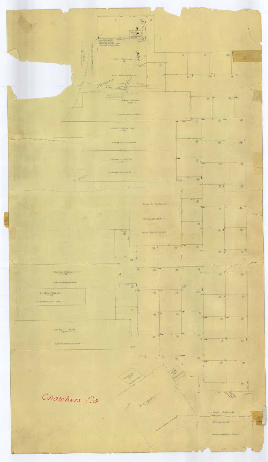
Chambers County Rolled Sketch 7
[Office Sketch of north part of Chambers County on Liberty County line]
-
Map/Doc
8611
-
Collection
General Map Collection
-
Counties
Chambers Liberty
-
Subjects
Surveying Rolled Sketch
-
Height x Width
39.8 x 23.1 inches
101.1 x 58.7 cm
-
Medium
paper, manuscript
Part of: General Map Collection
Flight Mission No. DAG-21K, Frame 125, Matagorda County

Print $20.00
- Digital $50.00
Flight Mission No. DAG-21K, Frame 125, Matagorda County
1952
Size 18.5 x 22.4 inches
Map/Doc 86451
Gray County Boundary File 2

Print $8.00
- Digital $50.00
Gray County Boundary File 2
Size 14.2 x 8.6 inches
Map/Doc 53850
St. L. S.-W. Ry. of Texas, Map of Lufkin Branch in Smith County, Texas

Print $40.00
- Digital $50.00
St. L. S.-W. Ry. of Texas, Map of Lufkin Branch in Smith County, Texas
1912
Size 24.3 x 122.9 inches
Map/Doc 64692
Hutchinson County Working Sketch 42

Print $20.00
- Digital $50.00
Hutchinson County Working Sketch 42
1978
Size 27.3 x 23.2 inches
Map/Doc 66402
Coke County Working Sketch 1

Print $20.00
- Digital $50.00
Coke County Working Sketch 1
Size 16.3 x 36.2 inches
Map/Doc 68038
Crane County Working Sketch 12

Print $20.00
- Digital $50.00
Crane County Working Sketch 12
1941
Size 18.6 x 18.1 inches
Map/Doc 68289
Ward County Rolled Sketch 24B

Print $40.00
- Digital $50.00
Ward County Rolled Sketch 24B
1967
Size 24.7 x 56.4 inches
Map/Doc 10115
Flight Mission No. CZW-2R, Frame 66, Hardeman County

Print $20.00
- Digital $50.00
Flight Mission No. CZW-2R, Frame 66, Hardeman County
1956
Size 18.6 x 22.4 inches
Map/Doc 85239
Trinity County Working Sketch 20

Print $20.00
- Digital $50.00
Trinity County Working Sketch 20
Size 25.9 x 29.7 inches
Map/Doc 69469
Harris County Rolled Sketch O

Print $20.00
- Digital $50.00
Harris County Rolled Sketch O
1913
Size 16.0 x 24.5 inches
Map/Doc 6140
[Surveys in the Bexar District]
![24, [Surveys in the Bexar District], General Map Collection](https://historictexasmaps.com/wmedia_w700/maps/24-1.tif.jpg)
Print $20.00
- Digital $50.00
[Surveys in the Bexar District]
1841
Size 23.0 x 16.5 inches
Map/Doc 24
Polk County Rolled Sketch FD

Print $40.00
- Digital $50.00
Polk County Rolled Sketch FD
Size 99.8 x 38.2 inches
Map/Doc 9754
You may also like
Map of Texas with population and location of principal towns and cities according to latest reliable statistics

Print $20.00
- Digital $50.00
Map of Texas with population and location of principal towns and cities according to latest reliable statistics
1921
Size 18.1 x 21.5 inches
Map/Doc 95880
No. 1 - Survey for a road from the Brazo Santiago to the Rio Grande

Print $20.00
- Digital $50.00
No. 1 - Survey for a road from the Brazo Santiago to the Rio Grande
1847
Size 18.4 x 27.3 inches
Map/Doc 72875
Topographic Map of Texas and Oklahoma Boundary, Fort Augur Area

Print $20.00
Topographic Map of Texas and Oklahoma Boundary, Fort Augur Area
1924
Size 20.3 x 33.0 inches
Map/Doc 79753
![94185, Texas [Recto], General Map Collection](https://historictexasmaps.com/wmedia_w700/maps/94185.tif.jpg)
Knox County Working Sketch 20

Print $20.00
- Digital $50.00
Knox County Working Sketch 20
2012
Size 40.2 x 36.9 inches
Map/Doc 93389
El Paso County Rolled Sketch 62

Print $20.00
- Digital $50.00
El Paso County Rolled Sketch 62
Size 30.0 x 39.4 inches
Map/Doc 5854
From Aransas Pass Eastward, Texas

Print $40.00
- Digital $50.00
From Aransas Pass Eastward, Texas
1866
Size 31.4 x 53.6 inches
Map/Doc 73426
Presidio County Working Sketch 25

Print $20.00
- Digital $50.00
Presidio County Working Sketch 25
1945
Size 22.8 x 18.9 inches
Map/Doc 71701
Briscoe County Working Sketch 5

Print $20.00
- Digital $50.00
Briscoe County Working Sketch 5
1934
Size 36.7 x 43.0 inches
Map/Doc 67808
Map of the State of Texas

Print $40.00
- Digital $50.00
Map of the State of Texas
1879
Size 47.1 x 51.4 inches
Map/Doc 2133
Liberty County Sketch File 26

Print $10.00
- Digital $50.00
Liberty County Sketch File 26
1859
Size 8.3 x 9.2 inches
Map/Doc 29943
Map of Mitchell County, Texas

Print $20.00
Map of Mitchell County, Texas
1890
Size 23.4 x 18.9 inches
Map/Doc 88980