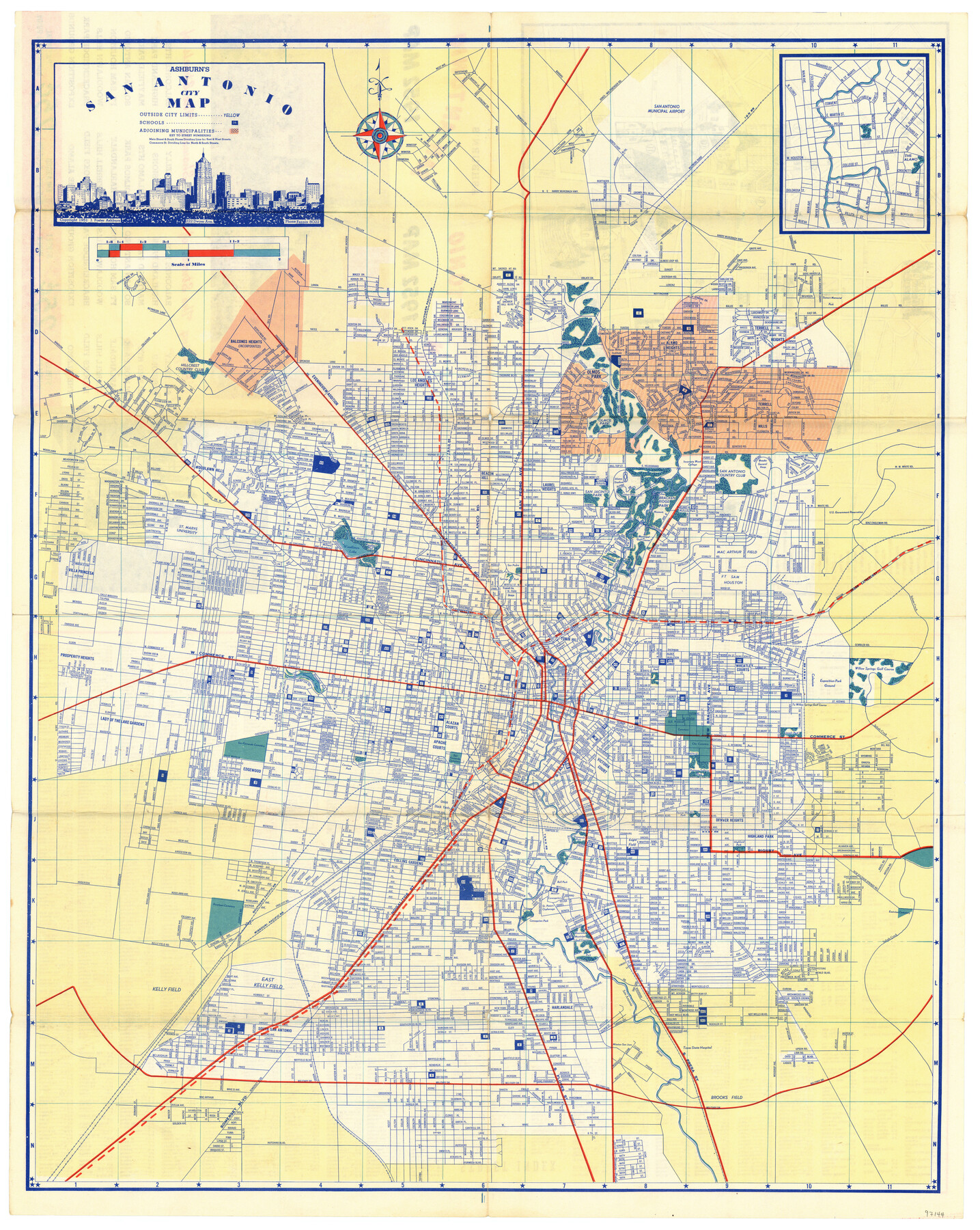
Ashburn's San Antonio City Map
-
Map/Doc
97144
-
Collection
General Map Collection
-
Object Dates
1951 (Creation Date)
1951 (Copyright Date)
-
People and Organizations
J. Foster Ashburn (Publisher)
-
Subjects
City
-
Height x Width
24.5 x 19.5 inches
62.2 x 49.5 cm
-
Comments
Map was originally folded in a brochure format and titled "Ashburn's San Antonio 1952 Map".
To view/download the verso which contains a street index, a "Downtown Pictorial Guide" and brief information about history, please click the "Download PDF" link above.
Copyrighted and unavailable for duplication. Posted for research only.
Part of: General Map Collection
Flight Mission No. DQN-7K, Frame 92, Calhoun County

Print $20.00
- Digital $50.00
Flight Mission No. DQN-7K, Frame 92, Calhoun County
1953
Size 17.2 x 19.1 inches
Map/Doc 84483
A Map of the United States including every county enumerated in the last census & since formed with the population of the several states, railroads, canals, & c.

A Map of the United States including every county enumerated in the last census & since formed with the population of the several states, railroads, canals, & c.
Size 46.0 x 61.0 inches
Map/Doc 95918
Hunt County Working Sketch 2

Print $20.00
- Digital $50.00
Hunt County Working Sketch 2
Size 20.5 x 16.5 inches
Map/Doc 66349
Map of Texas and Pacific Ry. Company's Surveys in the 80 Mile Reserve

Print $40.00
- Digital $50.00
Map of Texas and Pacific Ry. Company's Surveys in the 80 Mile Reserve
1885
Size 44.0 x 51.6 inches
Map/Doc 83557
Harbor of Brazos Santiago, Texas

Print $20.00
- Digital $50.00
Harbor of Brazos Santiago, Texas
1887
Size 27.2 x 18.4 inches
Map/Doc 72996
Brazoria County Rolled Sketch 46

Print $40.00
- Digital $50.00
Brazoria County Rolled Sketch 46
1950
Size 30.7 x 57.3 inches
Map/Doc 8462
Brewster County Working Sketch 81

Print $20.00
- Digital $50.00
Brewster County Working Sketch 81
1972
Size 45.9 x 26.7 inches
Map/Doc 67681
The Oil and Gas Journal's Oil Map of Texas

Print $20.00
- Digital $50.00
The Oil and Gas Journal's Oil Map of Texas
1938
Size 38.3 x 39.4 inches
Map/Doc 96970
Flight Mission No. BRA-7M, Frame 36, Jefferson County

Print $20.00
- Digital $50.00
Flight Mission No. BRA-7M, Frame 36, Jefferson County
1953
Size 18.7 x 22.3 inches
Map/Doc 85487
Hardin County Sketch File 35

Print $24.00
- Digital $50.00
Hardin County Sketch File 35
Size 9.2 x 8.4 inches
Map/Doc 25175
Cottle County Rolled Sketch B

Print $20.00
- Digital $50.00
Cottle County Rolled Sketch B
1903
Size 32.5 x 43.4 inches
Map/Doc 8671

You may also like
Moore County Rolled Sketch 14A

Print $20.00
- Digital $50.00
Moore County Rolled Sketch 14A
1981
Size 21.8 x 27.5 inches
Map/Doc 6831
The Republic County of Fannin. Created, December 14, 1837

Print $20.00
The Republic County of Fannin. Created, December 14, 1837
2020
Size 15.0 x 21.7 inches
Map/Doc 96128
[Maps of surveys in Reeves & Culberson Cos]
![61141, [Maps of surveys in Reeves & Culberson Cos], General Map Collection](https://historictexasmaps.com/wmedia_w700/maps/61141.tif.jpg)
Print $20.00
- Digital $50.00
[Maps of surveys in Reeves & Culberson Cos]
1937
Size 30.7 x 24.9 inches
Map/Doc 61141
[Sketch of Randall County]
![91757, [Sketch of Randall County], Twichell Survey Records](https://historictexasmaps.com/wmedia_w700/maps/91757-1.tif.jpg)
Print $20.00
- Digital $50.00
[Sketch of Randall County]
Size 21.4 x 18.5 inches
Map/Doc 91757
Upton County Working Sketch 25

Print $20.00
- Digital $50.00
Upton County Working Sketch 25
1953
Size 38.2 x 31.2 inches
Map/Doc 69521
Famous Heights Addition to Amarillo, Potter Co. Texas

Print $20.00
- Digital $50.00
Famous Heights Addition to Amarillo, Potter Co. Texas
Size 18.6 x 10.0 inches
Map/Doc 91744
Tarrant County Working Sketch 16

Print $20.00
- Digital $50.00
Tarrant County Working Sketch 16
1991
Size 14.5 x 23.9 inches
Map/Doc 62433
Hemphill County Sketch File 5

Print $8.00
- Digital $50.00
Hemphill County Sketch File 5
1903
Size 11.2 x 8.8 inches
Map/Doc 26295
Scurry County Working Sketch Graphic Index

Print $20.00
- Digital $50.00
Scurry County Working Sketch Graphic Index
1921
Size 39.9 x 37.0 inches
Map/Doc 76695
[I. & G. N. Block 1]
![91592, [I. & G. N. Block 1], Twichell Survey Records](https://historictexasmaps.com/wmedia_w700/maps/91592-1.tif.jpg)
Print $20.00
- Digital $50.00
[I. & G. N. Block 1]
Size 17.2 x 18.1 inches
Map/Doc 91592
Official Map City of Lubbock Lubbock County, Texas

Print $20.00
- Digital $50.00
Official Map City of Lubbock Lubbock County, Texas
1927
Size 44.6 x 33.4 inches
Map/Doc 93220
Hemphill County Sketch File 1

Print $40.00
- Digital $50.00
Hemphill County Sketch File 1
Size 17.1 x 13.9 inches
Map/Doc 26279