Swisher County Sketch File 1
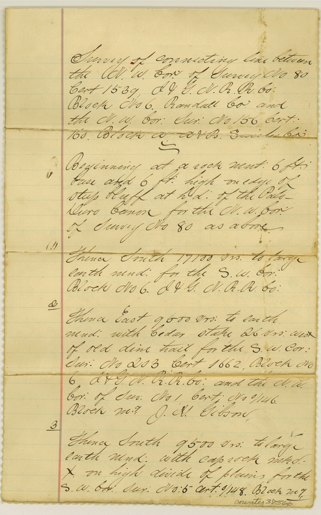
Survey of connecting line between the NW corner of sur. no. 80, cert. 1539, I. & G. N. R.R. Co. Block no. 6, Randall Co. and the NW corner of sur. no. 156, cert. 160, Block A, A. & B., Swisher Co. and sketch showing conflict of Blocks M10 and M15
-
Map/Doc
37566
-
Collection
General Map Collection
-
Object Dates
2/22/1884 (Creation Date)
2/27/1884 (File Date)
-
People and Organizations
T.S. McClelland (Surveyor/Engineer)
-
Counties
Swisher Randall
-
Subjects
Surveying Sketch File
-
Height x Width
13.0 x 8.2 inches
33.0 x 20.8 cm
-
Medium
paper, manuscript
-
Features
Palo Duro Canyon
Tule Creek
Part of: General Map Collection
[Surveys in Austin's Colony along the west bank of the Colorado River]
![199, [Surveys in Austin's Colony along the west bank of the Colorado River], General Map Collection](https://historictexasmaps.com/wmedia_w700/maps/199.tif.jpg)
Print $20.00
- Digital $50.00
[Surveys in Austin's Colony along the west bank of the Colorado River]
1831
Size 10.9 x 28.5 inches
Map/Doc 199
Anderson County Working Sketch 33

Print $20.00
- Digital $50.00
Anderson County Working Sketch 33
1966
Size 30.8 x 29.9 inches
Map/Doc 67033
Nueces County

Print $20.00
- Digital $50.00
Nueces County
1913
Size 26.9 x 35.9 inches
Map/Doc 95602
Map of Texas containing the Latest Grants & Discoveries

Print $20.00
- Digital $50.00
Map of Texas containing the Latest Grants & Discoveries
1836
Size 13.5 x 9.9 inches
Map/Doc 94039
Harris County Working Sketch 27

Print $20.00
- Digital $50.00
Harris County Working Sketch 27
1933
Size 36.9 x 43.0 inches
Map/Doc 65919
Trinity County Working Sketch 8

Print $3.00
- Digital $50.00
Trinity County Working Sketch 8
1941
Size 14.7 x 10.8 inches
Map/Doc 69457
Map of the Southwest Railway System

Print $20.00
- Digital $50.00
Map of the Southwest Railway System
1883
Size 16.0 x 28.8 inches
Map/Doc 93287
Flight Mission No. CGI-3N, Frame 98, Cameron County

Print $20.00
- Digital $50.00
Flight Mission No. CGI-3N, Frame 98, Cameron County
1954
Size 18.5 x 22.1 inches
Map/Doc 84578
Kinney County Working Sketch 13

Print $20.00
- Digital $50.00
Kinney County Working Sketch 13
1941
Size 20.3 x 23.9 inches
Map/Doc 70195
Pecos County Working Sketch 78

Print $20.00
- Digital $50.00
Pecos County Working Sketch 78
1960
Size 29.4 x 34.4 inches
Map/Doc 71550
Hudspeth County Working Sketch 8

Print $20.00
- Digital $50.00
Hudspeth County Working Sketch 8
1939
Size 27.3 x 33.1 inches
Map/Doc 66289
Red River County Working Sketch 7

Print $4.00
- Digital $50.00
Red River County Working Sketch 7
1919
Size 25.0 x 24.1 inches
Map/Doc 71990
You may also like
Map showing connections and corners made on ground in south part of Yoakum County and north part of Gaines County, Texas

Print $20.00
- Digital $50.00
Map showing connections and corners made on ground in south part of Yoakum County and north part of Gaines County, Texas
1938
Size 43.7 x 36.5 inches
Map/Doc 93255
Map of Shackelford County

Print $20.00
- Digital $50.00
Map of Shackelford County
1895
Size 24.1 x 19.5 inches
Map/Doc 4026
Flight Mission No. CRC-3R, Frame 100, Chambers County

Print $20.00
- Digital $50.00
Flight Mission No. CRC-3R, Frame 100, Chambers County
1956
Size 18.6 x 22.3 inches
Map/Doc 84838
Henderson County Working Sketch 21

Print $20.00
- Digital $50.00
Henderson County Working Sketch 21
1948
Size 17.1 x 16.2 inches
Map/Doc 66154
Harris County Working Sketch 72

Print $20.00
- Digital $50.00
Harris County Working Sketch 72
1958
Size 24.9 x 43.6 inches
Map/Doc 65964
Rusk County Sketch File 29

Print $8.00
Rusk County Sketch File 29
1949
Size 11.3 x 8.7 inches
Map/Doc 35554
Maps of Gulf Intracoastal Waterway, Texas - Sabine River to the Rio Grande and connecting waterways including ship channels

Print $20.00
- Digital $50.00
Maps of Gulf Intracoastal Waterway, Texas - Sabine River to the Rio Grande and connecting waterways including ship channels
1966
Size 15.7 x 22.0 inches
Map/Doc 61987
Cameron County Rolled Sketch Z5

Print $20.00
- Digital $50.00
Cameron County Rolled Sketch Z5
1937
Size 28.7 x 33.6 inches
Map/Doc 5403
Presidio County Rolled Sketch 39

Print $20.00
- Digital $50.00
Presidio County Rolled Sketch 39
Size 16.0 x 22.0 inches
Map/Doc 7336
Blanco County Sketch File 12

Print $20.00
- Digital $50.00
Blanco County Sketch File 12
Size 15.0 x 19.8 inches
Map/Doc 10928
Stephens County, Texas

Print $20.00
- Digital $50.00
Stephens County, Texas
1870
Size 21.0 x 17.7 inches
Map/Doc 756
Flight Mission No. BRE-2P, Frame 19, Nueces County

Print $20.00
- Digital $50.00
Flight Mission No. BRE-2P, Frame 19, Nueces County
1956
Size 18.4 x 22.2 inches
Map/Doc 86728