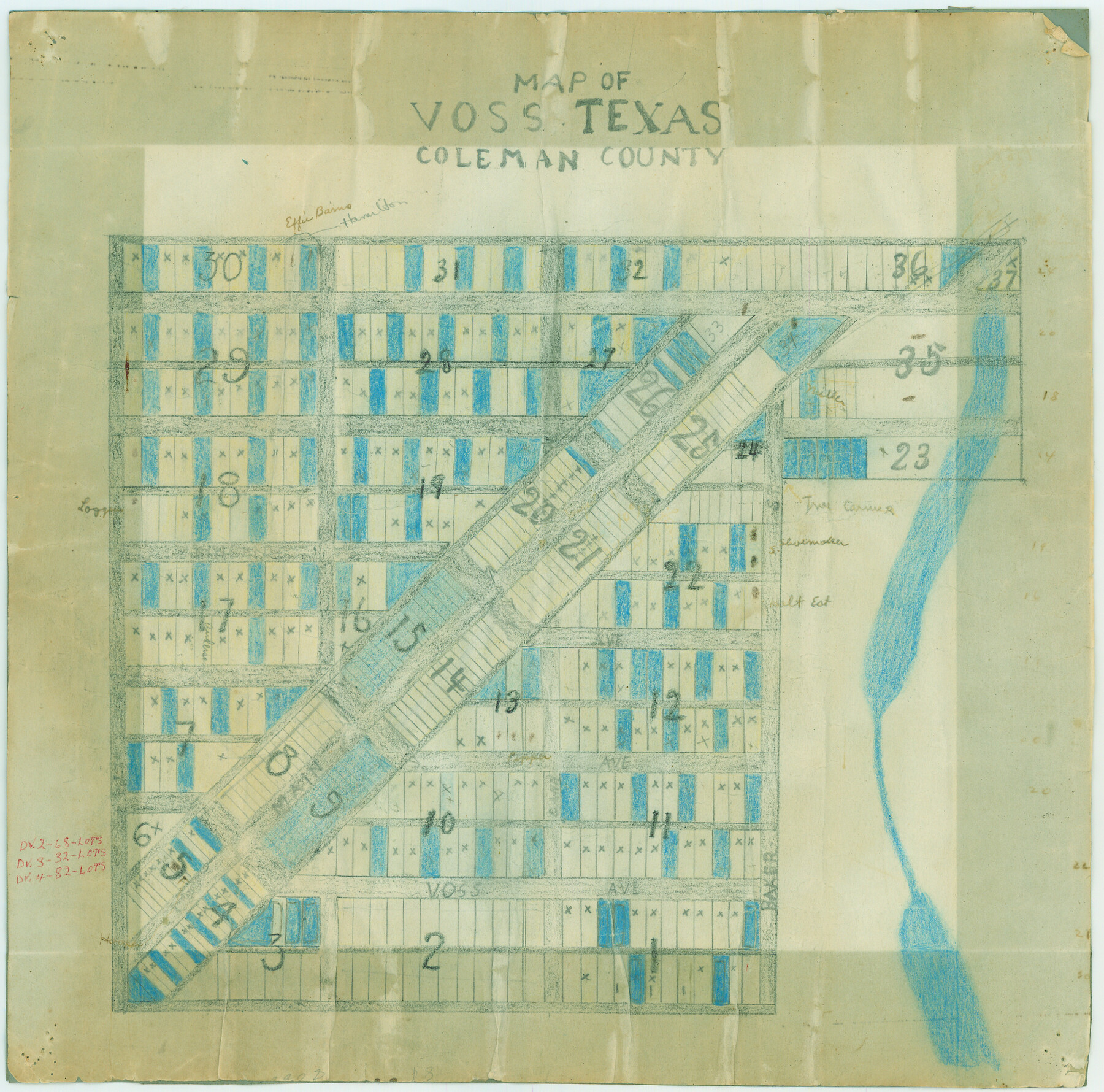
Map of Voss, Texas, Coleman County
-
Map/Doc
81519
-
Collection
General Map Collection
-
Counties
Coleman
-
Subjects
City
-
Height x Width
15.8 x 16.0 inches
40.1 x 40.6 cm
-
Medium
digital image
-
Comments
Part of a collection of the Miller Day Ranch in Coleman County, Texas. Original map donated to the University of Texas by James Miller.
Part of: General Map Collection
Sherman County Sketch File 8

Print $61.00
- Digital $50.00
Sherman County Sketch File 8
1993
Size 11.4 x 8.9 inches
Map/Doc 36726
Brewster County Sketch File NS-4a

Print $13.00
- Digital $50.00
Brewster County Sketch File NS-4a
Size 9.3 x 14.2 inches
Map/Doc 15953
Sterling County Sketch File 19

Print $8.00
- Digital $50.00
Sterling County Sketch File 19
1949
Size 11.2 x 8.6 inches
Map/Doc 37169
Preliminary Chart of Entrance to Brazos River, Texas

Print $20.00
- Digital $50.00
Preliminary Chart of Entrance to Brazos River, Texas
Size 17.6 x 19.8 inches
Map/Doc 81986
Crockett County Rolled Sketch 28

Print $20.00
- Digital $50.00
Crockett County Rolled Sketch 28
1884
Size 42.5 x 25.8 inches
Map/Doc 5587

Goliad County Rolled Sketch 6

Print $20.00
- Digital $50.00
Goliad County Rolled Sketch 6
1999
Size 23.4 x 34.5 inches
Map/Doc 6026
Baylor County Boundary File 3

Print $52.00
- Digital $50.00
Baylor County Boundary File 3
Size 23.2 x 4.9 inches
Map/Doc 50372
Orange County Sketch File 24

Print $6.00
- Digital $50.00
Orange County Sketch File 24
Size 8.9 x 15.7 inches
Map/Doc 33353
Runnels County Working Sketch 31

Print $20.00
- Digital $50.00
Runnels County Working Sketch 31
1959
Size 28.3 x 31.3 inches
Map/Doc 63629
Hudspeth County Working Sketch 31

Print $40.00
- Digital $50.00
Hudspeth County Working Sketch 31
1972
Size 56.2 x 41.2 inches
Map/Doc 66314
Kenedy County Rolled Sketch 14

Print $21.00
- Digital $50.00
Kenedy County Rolled Sketch 14
1951
Size 10.2 x 15.3 inches
Map/Doc 46433
You may also like
Cass County Working Sketch 28

Print $20.00
- Digital $50.00
Cass County Working Sketch 28
1979
Size 16.0 x 16.8 inches
Map/Doc 67931
A Pocket Guide to Austin, Texas - Area Map and Downtown Map

A Pocket Guide to Austin, Texas - Area Map and Downtown Map
Size 17.0 x 20.1 inches
Map/Doc 94385
Rockwall County Sketch File 8

Print $4.00
Rockwall County Sketch File 8
Size 7.1 x 10.6 inches
Map/Doc 35429
Map of Fayette County

Print $20.00
- Digital $50.00
Map of Fayette County
1865
Size 23.2 x 28.8 inches
Map/Doc 3540
Panola County Working Sketch 40

Print $20.00
- Digital $50.00
Panola County Working Sketch 40
1995
Map/Doc 71449
Coryell County Working Sketch 15

Print $20.00
- Digital $50.00
Coryell County Working Sketch 15
1957
Size 24.3 x 20.8 inches
Map/Doc 68222
[T. & N. O. RR. Co and H. & T. C. RR. Co. Blocks]
![90430, [T. & N. O. RR. Co and H. & T. C. RR. Co. Blocks], Twichell Survey Records](https://historictexasmaps.com/wmedia_w700/maps/90430-1.tif.jpg)
Print $2.00
- Digital $50.00
[T. & N. O. RR. Co and H. & T. C. RR. Co. Blocks]
1924
Size 8.3 x 8.2 inches
Map/Doc 90430
Lamar County Sketch File 6

Print $40.00
- Digital $50.00
Lamar County Sketch File 6
Size 16.2 x 13.4 inches
Map/Doc 29286
Austin Empresario Colony. July 9, 1828

Print $20.00
Austin Empresario Colony. July 9, 1828
2020
Size 16.4 x 21.7 inches
Map/Doc 95982
Val Verde County Rolled Sketch 64

Print $20.00
- Digital $50.00
Val Verde County Rolled Sketch 64
1937
Size 24.6 x 18.2 inches
Map/Doc 8129
Anderson County Working Sketch 31

Print $20.00
- Digital $50.00
Anderson County Working Sketch 31
1966
Size 18.3 x 23.2 inches
Map/Doc 67031
Map showing those portions of Texas traversed by Rock Island Lines and connections

Print $20.00
- Digital $50.00
Map showing those portions of Texas traversed by Rock Island Lines and connections
1904
Size 15.6 x 12.2 inches
Map/Doc 96588