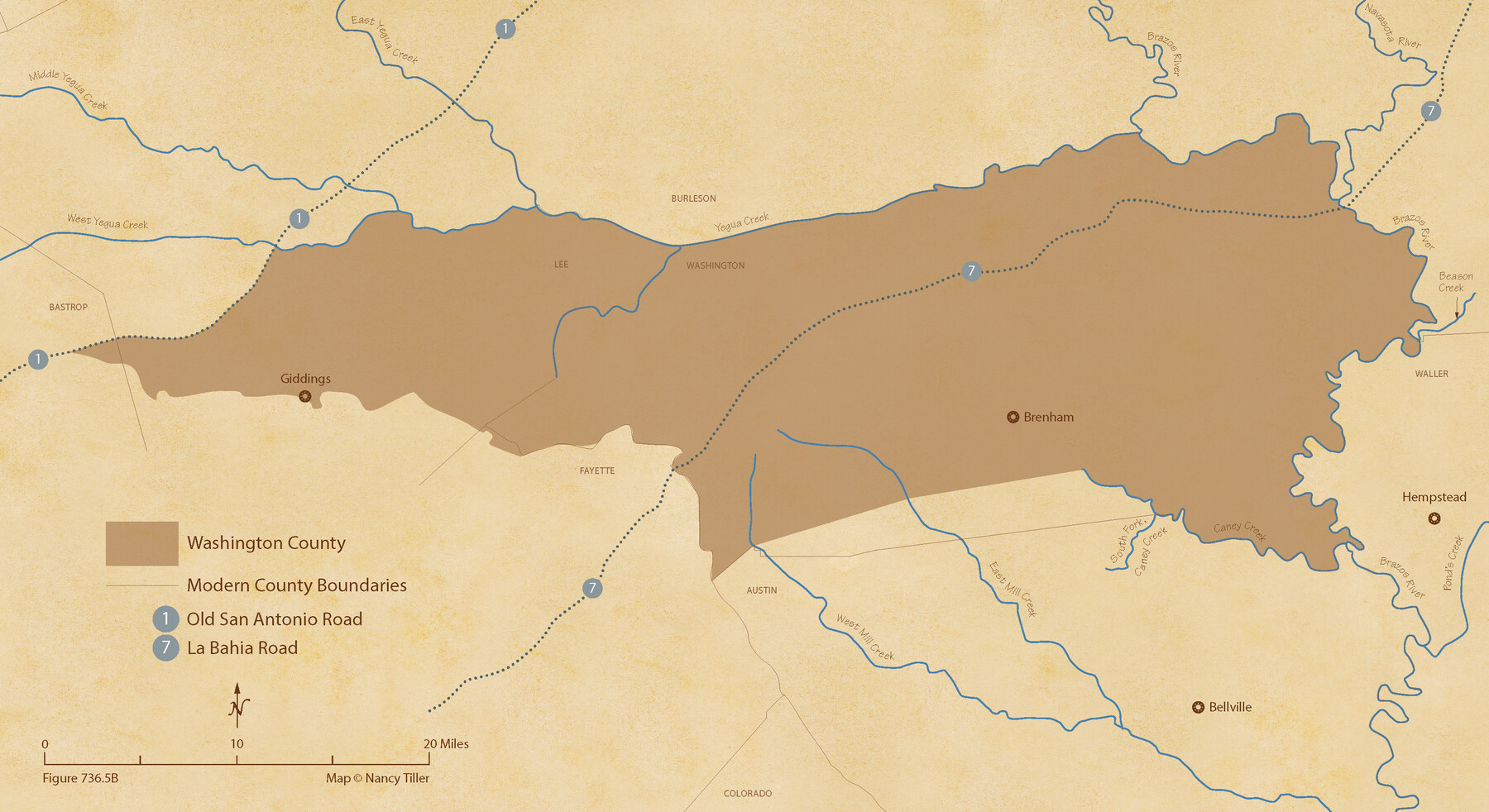
The Republic County of Washington. January 15, 1842
Figure No. 736.5 from 'A Boundary Atlas of Texas, 1821-1845' by Jim Tiller
-
Map/Doc
96306
-
Collection
Nancy and Jim Tiller Digital Collection
-
Object Dates
2020/1/1 (Creation Date)
-
People and Organizations
Jim Tiller (Author)
Nancy Tiller (Cartographer)
Gang Gong (GIS Professional)
-
Counties
Washington
-
Subjects
Atlas County Republic of Texas Texas Boundaries
-
Height x Width
11.8 x 21.7 inches
30.0 x 55.1 cm
-
Medium
digital image
-
Comments
To purchase a digital PDF copy of "A Boundary Atlas of Texas, 1821-1845" see 96437.
Part of: Nancy and Jim Tiller Digital Collection
Text (Possibly Legislative) Describing the Boundaries of Washington County, Undated

Print $20.00
Text (Possibly Legislative) Describing the Boundaries of Washington County, Undated
2020
Size 20.0 x 21.7 inches
Map/Doc 96407
The Republic County of Nacogdoches. Proposed, Late Fall 1837

Print $20.00
The Republic County of Nacogdoches. Proposed, Late Fall 1837
2020
Size 17.5 x 21.7 inches
Map/Doc 96242

The Republic County of Robertson. Spring 1842

Print $20.00
The Republic County of Robertson. Spring 1842
2020
Size 16.9 x 21.7 inches
Map/Doc 96263
The Land Offices. No. 4, Nacogdoches, December 22, 1836

Print $20.00
The Land Offices. No. 4, Nacogdoches, December 22, 1836
2020
Size 14.8 x 21.7 inches
Map/Doc 96417
The Republic County of Bexar. Spring 1842

Print $20.00
The Republic County of Bexar. Spring 1842
2020
Size 14.7 x 21.7 inches
Map/Doc 96100
Grant and Beales Empresario Colony. October 9, 1832

Print $20.00
Grant and Beales Empresario Colony. October 9, 1832
2020
Size 23.5 x 21.7 inches
Map/Doc 95996
The Republic County of Robertson. Created, December 14, 1837

Print $20.00
The Republic County of Robertson. Created, December 14, 1837
2020
Size 18.9 x 21.6 inches
Map/Doc 96259
The Mexican Department of Bexar. January 31, 1831

Print $20.00
The Mexican Department of Bexar. January 31, 1831
2020
Size 16.1 x 21.7 inches
Map/Doc 95968
Burnet Empresario Colony. December 22, 1826

Print $20.00
Burnet Empresario Colony. December 22, 1826
2020
Size 12.9 x 21.6 inches
Map/Doc 95985
The Republic County of Milam. Proposed, Late Fall 1837

Print $20.00
The Republic County of Milam. Proposed, Late Fall 1837
2020
Size 19.9 x 21.7 inches
Map/Doc 96225
The Republic County of San Augustine. December 29, 1845

Print $20.00
The Republic County of San Augustine. December 29, 1845
2020
Size 18.8 x 21.7 inches
Map/Doc 96272
You may also like
Deputy Surveyors Field Note Book, San Patricio County

Deputy Surveyors Field Note Book, San Patricio County
1838
Map/Doc 96675
[Sketch showing surveys near Brushy Creek and Old Thrall Oil Field]
![90421, [Sketch showing surveys near Brushy Creek and Old Thrall Oil Field], Twichell Survey Records](https://historictexasmaps.com/wmedia_w700/maps/90421-1.tif.jpg)
Print $20.00
- Digital $50.00
[Sketch showing surveys near Brushy Creek and Old Thrall Oil Field]
Size 27.4 x 42.6 inches
Map/Doc 90421
Section 10, Block Z, Cochran County, Texas

Print $20.00
- Digital $50.00
Section 10, Block Z, Cochran County, Texas
1952
Size 12.2 x 17.0 inches
Map/Doc 92521
Kinney County Sketch File 39

Print $20.00
- Digital $50.00
Kinney County Sketch File 39
1948
Size 18.8 x 21.0 inches
Map/Doc 11951
Calhoun County Working Sketch 10

Print $20.00
- Digital $50.00
Calhoun County Working Sketch 10
1951
Size 36.8 x 37.2 inches
Map/Doc 67826
Webb County Sketch File 63

Print $20.00
- Digital $50.00
Webb County Sketch File 63
1947
Size 17.2 x 21.2 inches
Map/Doc 12653
[Part of H. & G. N. Blocks 2 and D-13]
![90490, [Part of H. & G. N. Blocks 2 and D-13], Twichell Survey Records](https://historictexasmaps.com/wmedia_w700/maps/90490-1.tif.jpg)
Print $20.00
- Digital $50.00
[Part of H. & G. N. Blocks 2 and D-13]
1907
Size 14.1 x 17.7 inches
Map/Doc 90490
Sterling County Sketch File 14

Print $20.00
- Digital $50.00
Sterling County Sketch File 14
Size 18.9 x 16.4 inches
Map/Doc 12360
Newton County Rolled Sketch 27A

Print $20.00
- Digital $50.00
Newton County Rolled Sketch 27A
1961
Size 35.9 x 27.1 inches
Map/Doc 6857
McMullen County Rolled Sketch 7

Print $40.00
- Digital $50.00
McMullen County Rolled Sketch 7
1939
Size 38.8 x 51.7 inches
Map/Doc 9500
Live Oak County Working Sketch 21

Print $20.00
- Digital $50.00
Live Oak County Working Sketch 21
1964
Size 30.8 x 33.9 inches
Map/Doc 70606
Duval County Sketch File 19

Print $4.00
- Digital $50.00
Duval County Sketch File 19
1880
Size 10.3 x 8.2 inches
Map/Doc 21316