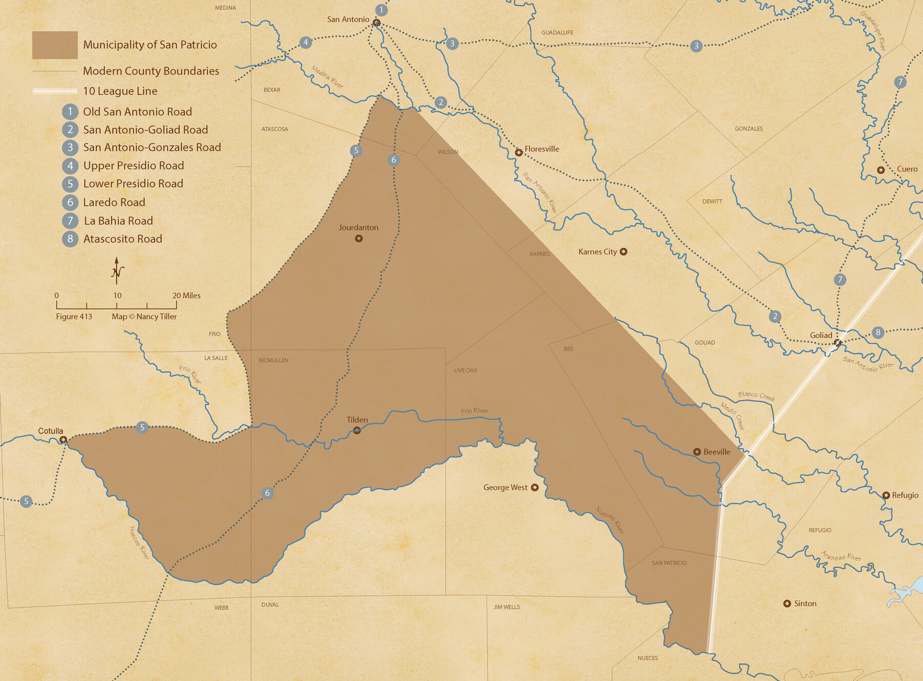
The Mexican Municipality of San Patricio. April 1834
Figure No. 413 from 'A Boundary Atlas of Texas, 1821-1845' by Jim Tiller
-
Map/Doc
96034
-
Collection
Nancy and Jim Tiller Digital Collection
-
Object Dates
2020/1/1 (Creation Date)
-
People and Organizations
Jim Tiller (Author)
Nancy Tiller (Cartographer)
Gang Gong (GIS Professional)
-
Subjects
Atlas Mexican Texas Texas Boundaries
-
Height x Width
16.0 x 21.7 inches
40.6 x 55.1 cm
-
Medium
digital image
-
Comments
To purchase a digital PDF copy of "A Boundary Atlas of Texas, 1821-1845" see 96437.
Part of: Nancy and Jim Tiller Digital Collection
The Mexican Municipality of Mina. ca. Spring 1835

Print $20.00
The Mexican Municipality of Mina. ca. Spring 1835
2020
Size 10.7 x 21.8 inches
Map/Doc 96029
The Republic County of Refugio. December 29, 1845

Print $20.00
The Republic County of Refugio. December 29, 1845
2020
Size 22.3 x 21.6 inches
Map/Doc 96258
The Republic County of Brazoria. January 1, 1838

Print $20.00
The Republic County of Brazoria. January 1, 1838
2020
Size 14.7 x 21.8 inches
Map/Doc 96111
The Republic County of Washington. January 30, 1841

Print $20.00
The Republic County of Washington. January 30, 1841
2020
Size 20.3 x 21.7 inches
Map/Doc 96305
The Republic County of Nacogdoches. Proposed, Late Fall 1837-January 1, 1838

Print $20.00
The Republic County of Nacogdoches. Proposed, Late Fall 1837-January 1, 1838
2020
Size 17.8 x 21.7 inches
Map/Doc 96243
The Republic County of Gonzales. January 29, 1842

Print $20.00
The Republic County of Gonzales. January 29, 1842
2020
Size 14.7 x 21.7 inches
Map/Doc 96157
The Republic County of Fayette. May 24, 1838

Print $20.00
The Republic County of Fayette. May 24, 1838
2020
Size 14.7 x 21.7 inches
Map/Doc 96133
From Citizens of Montgomery County for the Creation of a New County to be Called Bowie, January 18, 1838

Print $20.00
From Citizens of Montgomery County for the Creation of a New County to be Called Bowie, January 18, 1838
2020
Size 19.1 x 21.7 inches
Map/Doc 96376
The Republic County of Robertson. January 30, 1841

Print $20.00
The Republic County of Robertson. January 30, 1841
2020
Size 16.9 x 21.7 inches
Map/Doc 96261
Cameron Empresario Colony. May 21, 1827

Print $20.00
Cameron Empresario Colony. May 21, 1827
2020
Size 10.7 x 21.7 inches
Map/Doc 95986
From Citizens of Gonzales County for the Creation of a New Judicial County (Unnamed), December 14, 1841

Print $20.00
From Citizens of Gonzales County for the Creation of a New Judicial County (Unnamed), December 14, 1841
2020
Size 24.1 x 21.7 inches
Map/Doc 96410
The Mexican Municipality of Matagorda. December 5, 1835

Print $20.00
The Mexican Municipality of Matagorda. December 5, 1835
2020
Size 15.9 x 21.7 inches
Map/Doc 96027
You may also like
United States - Gulf Coast - From Latitude 26° 33' to the Rio Grande Texas

Print $20.00
- Digital $50.00
United States - Gulf Coast - From Latitude 26° 33' to the Rio Grande Texas
1913
Size 27.9 x 18.2 inches
Map/Doc 72832
Trinity River, Map of J. B. Bradley's Levee in Valley of Cummins Creek about 2 1/2 Miles South of Rice Showing Proposed Change of Location

Print $2.00
- Digital $50.00
Trinity River, Map of J. B. Bradley's Levee in Valley of Cummins Creek about 2 1/2 Miles South of Rice Showing Proposed Change of Location
1950
Size 13.9 x 16.1 inches
Map/Doc 65246
Sectional Map No. 2 of the lands and the line of the Texas & Pacific Ry. Co. in Howard, Martin, Andrews, Midland and Tom Green Counties

Print $20.00
- Digital $50.00
Sectional Map No. 2 of the lands and the line of the Texas & Pacific Ry. Co. in Howard, Martin, Andrews, Midland and Tom Green Counties
1885
Size 19.1 x 23.2 inches
Map/Doc 4860
Pecos County Working Sketch 91b

Print $40.00
- Digital $50.00
Pecos County Working Sketch 91b
1965
Size 78.9 x 32.7 inches
Map/Doc 71564
Chambers County Rolled Sketch 12C

Print $97.00
- Digital $50.00
Chambers County Rolled Sketch 12C
Size 10.0 x 15.2 inches
Map/Doc 43939
Brazoria County Sketch File 8

Print $4.00
- Digital $50.00
Brazoria County Sketch File 8
1874
Size 12.4 x 8.4 inches
Map/Doc 14934
[List of W.C. RR. Co. Certificates]
![60504, [List of W.C. RR. Co. Certificates], General Map Collection](https://historictexasmaps.com/wmedia_w700/pdf_converted_jpg/qi_pdf_thumbnail_17018.jpg)
Print $28.00
[List of W.C. RR. Co. Certificates]
1930
Size 14.4 x 8.9 inches
Map/Doc 60504
Hutchinson County Working Sketch 34

Print $20.00
- Digital $50.00
Hutchinson County Working Sketch 34
1978
Size 27.0 x 22.9 inches
Map/Doc 66394
Crockett County Working Sketch 6

Print $20.00
- Digital $50.00
Crockett County Working Sketch 6
Size 20.7 x 21.7 inches
Map/Doc 68339
Tarrant County Working Sketch 12

Print $20.00
- Digital $50.00
Tarrant County Working Sketch 12
1986
Size 30.8 x 23.4 inches
Map/Doc 62429
Republic Counties. January 1, 1845

Print $20.00
Republic Counties. January 1, 1845
2020
Size 24.5 x 21.7 inches
Map/Doc 96318
Borden County Working Sketch 11

Print $40.00
- Digital $50.00
Borden County Working Sketch 11
1955
Size 51.6 x 26.5 inches
Map/Doc 67471