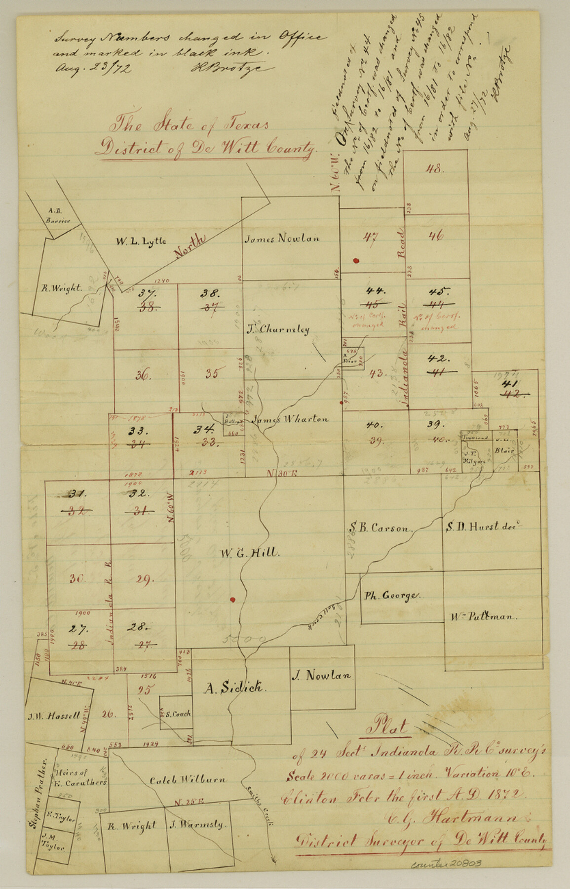
DeWitt County Sketch File 5
Plat of 24 sections Indianola RR. Co. Surveys
-
Map/Doc
20803
-
Collection
General Map Collection
-
Object Dates
1872/2/1 (Creation Date)
1872/8/27 (File Date)
-
People and Organizations
C.G. Hartmann (Surveyor/Engineer)
-
Counties
DeWitt
-
Subjects
Surveying Sketch File
-
Height x Width
13.0 x 8.3 inches
33.0 x 21.1 cm
-
Medium
paper, manuscript
-
Scale
1:2000
-
Features
Salt Creek
Smith's Creek
Part of: General Map Collection
Flight Mission No. DCL-7C, Frame 123, Kenedy County

Print $20.00
- Digital $50.00
Flight Mission No. DCL-7C, Frame 123, Kenedy County
1943
Size 18.5 x 22.2 inches
Map/Doc 86088
Colorado County Sketch File 21

Print $8.00
- Digital $50.00
Colorado County Sketch File 21
Size 13.1 x 8.8 inches
Map/Doc 18957
Parker County Sketch File 12

Print $4.00
- Digital $50.00
Parker County Sketch File 12
1858
Size 9.1 x 7.1 inches
Map/Doc 33544
Kinney County Working Sketch 29

Print $20.00
- Digital $50.00
Kinney County Working Sketch 29
1959
Size 37.8 x 33.8 inches
Map/Doc 70211
Jackson County Sketch File 17

Print $20.00
- Digital $50.00
Jackson County Sketch File 17
1913
Size 19.4 x 19.1 inches
Map/Doc 11841
Brooks County Sketch File 9

Print $2.00
- Digital $50.00
Brooks County Sketch File 9
1988
Size 14.4 x 8.8 inches
Map/Doc 16571
Right of Way and Track Map Texas & New Orleans R.R. Co. operated by the T. & N. O. R.R. Co. Dallas-Sabine Branch

Print $40.00
- Digital $50.00
Right of Way and Track Map Texas & New Orleans R.R. Co. operated by the T. & N. O. R.R. Co. Dallas-Sabine Branch
1918
Size 26.4 x 56.7 inches
Map/Doc 64154
Flight Mission No. DQN-1K, Frame 114, Calhoun County

Print $20.00
- Digital $50.00
Flight Mission No. DQN-1K, Frame 114, Calhoun County
1953
Size 18.5 x 22.3 inches
Map/Doc 84180
Donley County Rolled Sketch 6

Print $40.00
- Digital $50.00
Donley County Rolled Sketch 6
1982
Size 42.9 x 66.6 inches
Map/Doc 8802
Houston County Working Sketch 30

Print $20.00
- Digital $50.00
Houston County Working Sketch 30
1990
Size 36.9 x 37.0 inches
Map/Doc 66260
Mason County Boundary File 3

Print $52.00
- Digital $50.00
Mason County Boundary File 3
Size 13.7 x 8.7 inches
Map/Doc 56838
Flight Mission No. DQN-5K, Frame 145, Calhoun County

Print $20.00
- Digital $50.00
Flight Mission No. DQN-5K, Frame 145, Calhoun County
1953
Size 18.5 x 22.1 inches
Map/Doc 84420
You may also like
Motley County Sketch File B (S)

Print $40.00
- Digital $50.00
Motley County Sketch File B (S)
Size 14.2 x 12.4 inches
Map/Doc 32157
Montague County Boundary File 2d

Print $4.00
- Digital $50.00
Montague County Boundary File 2d
Size 12.5 x 8.2 inches
Map/Doc 57432
[Maps of surveys in Reeves & Culberson Cos]
![61136, [Maps of surveys in Reeves & Culberson Cos], General Map Collection](https://historictexasmaps.com/wmedia_w700/maps/61136.tif.jpg)
Print $20.00
- Digital $50.00
[Maps of surveys in Reeves & Culberson Cos]
1937
Size 30.5 x 24.7 inches
Map/Doc 61136
Marion County Sketch File 19

Print $20.00
- Digital $50.00
Marion County Sketch File 19
2001
Size 11.2 x 8.8 inches
Map/Doc 30616
Corpus Christi Pass

Print $20.00
- Digital $50.00
Corpus Christi Pass
Size 46.2 x 41.4 inches
Map/Doc 78455
Crockett County Sketch File A

Print $40.00
- Digital $50.00
Crockett County Sketch File A
Size 21.9 x 7.5 inches
Map/Doc 19624
Map of Surveys Made for the T&PRR in Borden, Dawson, Howard & Martin Counties, Blocks 32, 33, 34, 35 & 36, Reserve West of the Colorado

Print $20.00
- Digital $50.00
Map of Surveys Made for the T&PRR in Borden, Dawson, Howard & Martin Counties, Blocks 32, 33, 34, 35 & 36, Reserve West of the Colorado
1876
Size 42.0 x 38.2 inches
Map/Doc 2231
Val Verde Co.

Print $20.00
- Digital $50.00
Val Verde Co.
1908
Size 40.5 x 38.4 inches
Map/Doc 63099
Flight Mission No. DAG-21K, Frame 97, Matagorda County

Print $20.00
- Digital $50.00
Flight Mission No. DAG-21K, Frame 97, Matagorda County
1952
Size 18.4 x 22.2 inches
Map/Doc 86426
Jefferson County Rolled Sketch 45

Print $20.00
- Digital $50.00
Jefferson County Rolled Sketch 45
1959
Size 31.2 x 27.3 inches
Map/Doc 6402
United States - Gulf Coast - Galveston to Rio Grande

Print $20.00
- Digital $50.00
United States - Gulf Coast - Galveston to Rio Grande
1919
Size 26.7 x 18.2 inches
Map/Doc 72744
Edwards County Working Sketch Graphic Index - west part

Print $40.00
- Digital $50.00
Edwards County Working Sketch Graphic Index - west part
1975
Size 57.4 x 38.1 inches
Map/Doc 76532