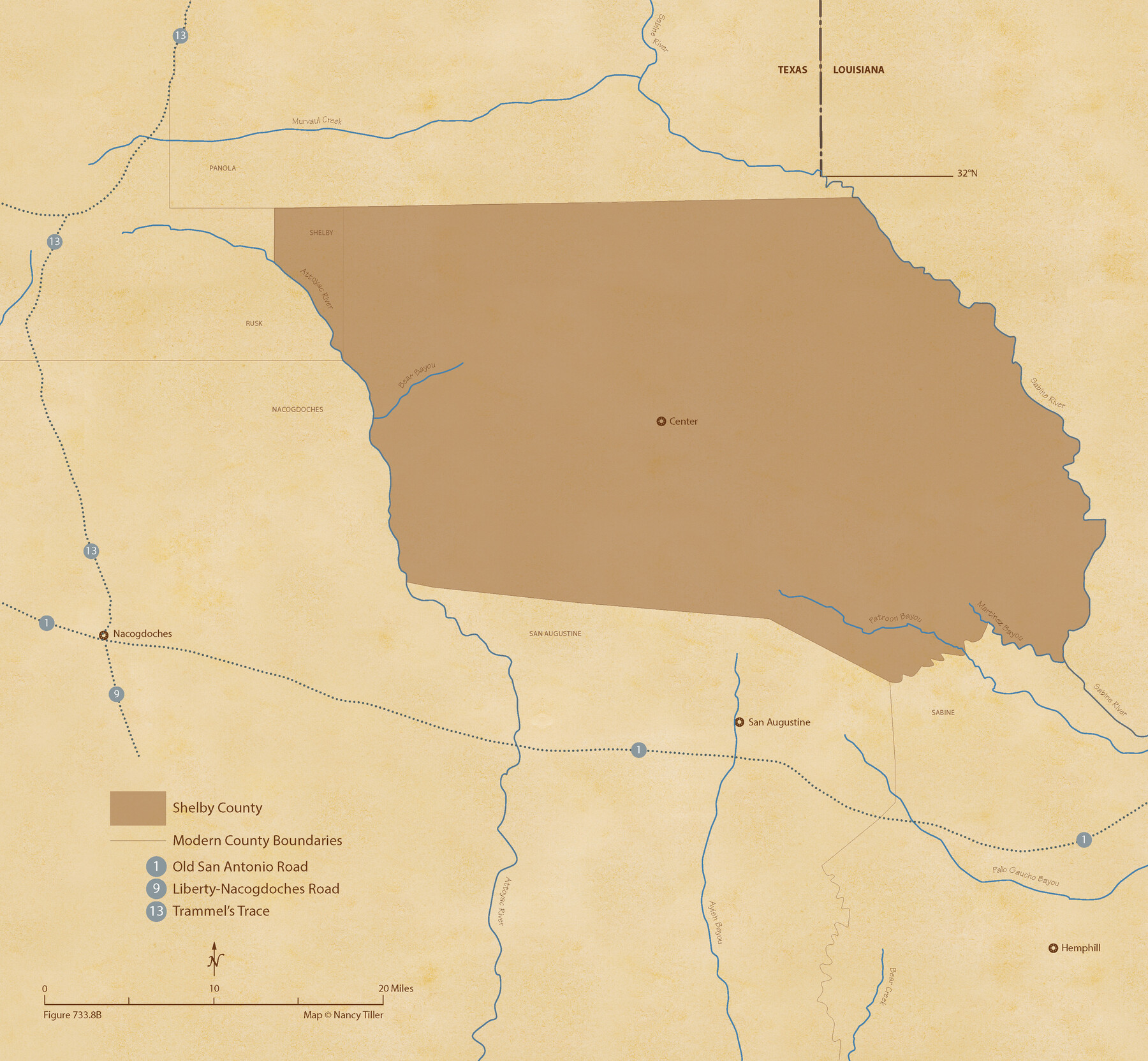
The Republic County of Shelby. February 1, 1845
Figure No. 733.8 from 'A Boundary Atlas of Texas, 1821-1845' by Jim Tiller
-
Map/Doc
96287
-
Collection
Nancy and Jim Tiller Digital Collection
-
Object Dates
2020/1/1 (Creation Date)
-
People and Organizations
Jim Tiller (Author)
Nancy Tiller (Cartographer)
Gang Gong (GIS Professional)
-
Counties
Shelby
-
Subjects
Atlas County Republic of Texas Texas Boundaries
-
Height x Width
20.0 x 21.7 inches
50.8 x 55.1 cm
-
Medium
digital image
-
Comments
To purchase a digital PDF copy of "A Boundary Atlas of Texas, 1821-1845" see 96437.
Part of: Nancy and Jim Tiller Digital Collection
The Republic County of Montgomery. Created, December 14, 1837

Print $20.00
The Republic County of Montgomery. Created, December 14, 1837
2020
Size 19.9 x 21.7 inches
Map/Doc 96234
The Republic County of Victoria. September 18, 1838

Print $20.00
The Republic County of Victoria. September 18, 1838
2020
Size 24.3 x 21.7 inches
Map/Doc 96296
The Mercer Colony. January 29, 1844

Print $20.00
The Mercer Colony. January 29, 1844
2020
Size 19.8 x 21.7 inches
Map/Doc 96361
Vehlein and Company Empresario Colony. December 21, 1826

Print $20.00
Vehlein and Company Empresario Colony. December 21, 1826
2020
Size 20.8 x 21.7 inches
Map/Doc 96007
The Republic County of Austin. Defined, May 24, 1838

Print $20.00
The Republic County of Austin. Defined, May 24, 1838
2020
Size 14.7 x 21.6 inches
Map/Doc 96082
The Chief Justice County of Liberty. Lands in Conflict with Harrisburg County

Print $20.00
The Chief Justice County of Liberty. Lands in Conflict with Harrisburg County
2020
Size 20.5 x 21.7 inches
Map/Doc 96056
From Citizens of Southwestern Nacogdoches County for the Creation of a New Judicial County (Unnamed), Undated

Print $20.00
From Citizens of Southwestern Nacogdoches County for the Creation of a New Judicial County (Unnamed), Undated
2020
Size 19.9 x 21.7 inches
Map/Doc 96412
The Republic County of Matagorda. December 29, 1845

Print $20.00
The Republic County of Matagorda. December 29, 1845
2020
Size 21.0 x 21.7 inches
Map/Doc 96224
The Republic County of Bowie. December 29, 1845

Print $20.00
The Republic County of Bowie. December 29, 1845
2020
Size 19.5 x 21.7 inches
Map/Doc 96108
The Judicial District/County of Trinity. Created, December 7, 1841

Print $20.00
The Judicial District/County of Trinity. Created, December 7, 1841
2020
Size 14.7 x 21.7 inches
Map/Doc 96350
The Republic County of Brazoria. December 16, 1839

Print $20.00
The Republic County of Brazoria. December 16, 1839
2020
Size 14.7 x 21.8 inches
Map/Doc 96113
The Land Offices. No. 1, Red River, December 22, 1836

Print $20.00
The Land Offices. No. 1, Red River, December 22, 1836
2020
Size 13.7 x 21.7 inches
Map/Doc 96414
You may also like
[D. & S. E. Surs., G. C. & S. F. Blk. 9 west of University Land Blks. 49 and 50]
![90308, [D. & S. E. Surs., G. C. & S. F. Blk. 9 west of University Land Blks. 49 and 50], Twichell Survey Records](https://historictexasmaps.com/wmedia_w700/maps/90308-1.tif.jpg)
Print $3.00
- Digital $50.00
[D. & S. E. Surs., G. C. & S. F. Blk. 9 west of University Land Blks. 49 and 50]
Size 11.3 x 15.4 inches
Map/Doc 90308
G&H Blocks Gaines Co. Resurvey 1915

Print $40.00
- Digital $50.00
G&H Blocks Gaines Co. Resurvey 1915
1915
Size 56.8 x 31.3 inches
Map/Doc 89632
Refugio County NRC Article 33.136 Location Key Sheet

Print $20.00
- Digital $50.00
Refugio County NRC Article 33.136 Location Key Sheet
Size 26.3 x 22.3 inches
Map/Doc 87912
University of Texas System University Lands

Print $20.00
- Digital $50.00
University of Texas System University Lands
Size 17.7 x 23.2 inches
Map/Doc 93242
Coke County Sketch File 5

Print $8.00
- Digital $50.00
Coke County Sketch File 5
1886
Size 12.4 x 8.2 inches
Map/Doc 18578
Val Verde County Sketch File B1

Print $20.00
- Digital $50.00
Val Verde County Sketch File B1
1905
Size 21.3 x 20.7 inches
Map/Doc 12543
Hutchinson County Sketch File 37

Print $10.00
- Digital $50.00
Hutchinson County Sketch File 37
Size 11.3 x 8.8 inches
Map/Doc 27275
El Paso County Working Sketch 21

Print $20.00
- Digital $50.00
El Paso County Working Sketch 21
1960
Size 37.8 x 30.9 inches
Map/Doc 69043
Crockett County Working Sketch 4

Print $40.00
- Digital $50.00
Crockett County Working Sketch 4
Size 26.8 x 70.4 inches
Map/Doc 68337

Kendall County Sketch File 18

Print $4.00
- Digital $50.00
Kendall County Sketch File 18
1882
Size 10.0 x 6.7 inches
Map/Doc 28711
Travis County Sketch File 15

Print $4.00
- Digital $50.00
Travis County Sketch File 15
Size 12.8 x 8.1 inches
Map/Doc 38310