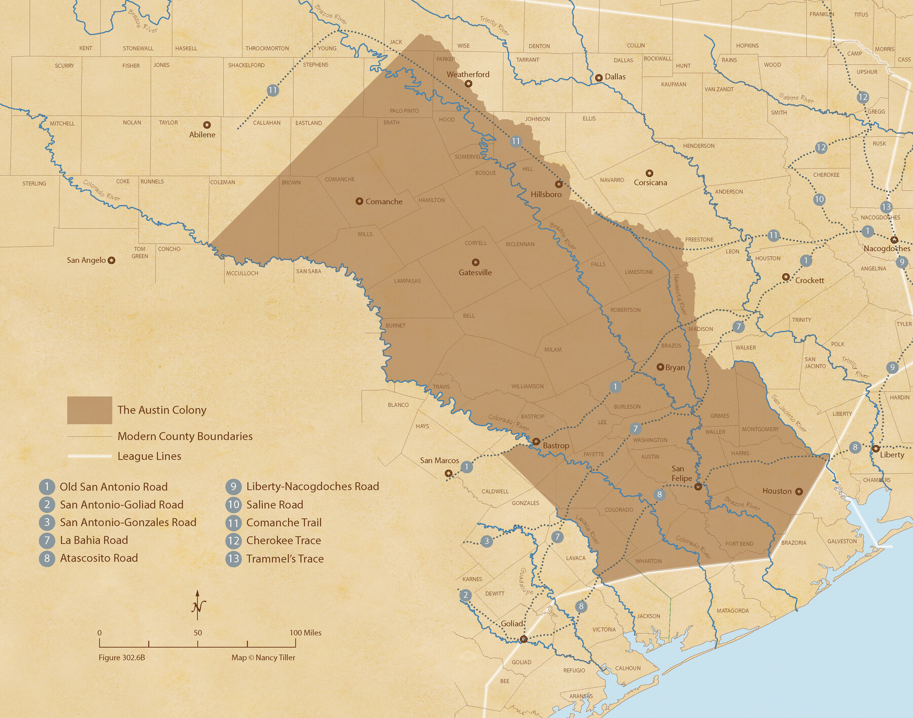
Austin Empresario Colony. February 25, 1831
Figure No. 302.6 from 'A Boundary Atlas of Texas, 1821-1845' by Jim Tiller
-
Map/Doc
95983
-
Collection
Nancy and Jim Tiller Digital Collection
-
Object Dates
2020/1/1 (Creation Date)
-
People and Organizations
Jim Tiller (Author)
Nancy Tiller (Cartographer)
Gang Gong (GIS Professional)
-
Subjects
Atlas Colony Mexican Texas Texas Boundaries
-
Height x Width
17.0 x 21.7 inches
43.2 x 55.1 cm
-
Medium
digital image
-
Comments
To purchase a digital PDF copy of "A Boundary Atlas of Texas, 1821-1845" see 96437.
Part of: Nancy and Jim Tiller Digital Collection
From Citizens of Red River County for the Creation of a New County to be Called Aurora, December 3, 1840

Print $20.00
From Citizens of Red River County for the Creation of a New County to be Called Aurora, December 3, 1840
2020
Size 19.8 x 21.7 inches
Map/Doc 96391
The Peters Colony. November 9, 1841

Print $20.00
The Peters Colony. November 9, 1841
2020
Size 21.7 x 21.7 inches
Map/Doc 96363
Text (Possibly Legislative) Describing the Boundaries of Washington County, Undated

Print $20.00
Text (Possibly Legislative) Describing the Boundaries of Washington County, Undated
2020
Size 20.0 x 21.7 inches
Map/Doc 96407
The Republic County of Matagorda. January 19, 1841

Print $20.00
The Republic County of Matagorda. January 19, 1841
2020
Size 21.0 x 21.7 inches
Map/Doc 96220
The Judicial District/County of Smith. Abolished, Spring 1842

Print $20.00
The Judicial District/County of Smith. Abolished, Spring 1842
2020
Size 19.6 x 21.7 inches
Map/Doc 96347
The Judicial District/County of Hamilton. Abolished, Spring 1842

Print $20.00
The Judicial District/County of Hamilton. Abolished, Spring 1842
2020
Size 14.9 x 21.7 inches
Map/Doc 96330
The Mexican Municipality of Washington. Proposed Creation, ca Spring 1835

Print $20.00
The Mexican Municipality of Washington. Proposed Creation, ca Spring 1835
2020
Size 13.1 x 21.7 inches
Map/Doc 96035
From Citizens of Liberty County for the Creation a New County to be Called Crockett, November 12, 1838

Print $20.00
From Citizens of Liberty County for the Creation a New County to be Called Crockett, November 12, 1838
2020
Size 22.3 x 21.7 inches
Map/Doc 96385
The Republic County of Travis. Refined, February 5, 1840

Print $20.00
The Republic County of Travis. Refined, February 5, 1840
2020
Size 20.8 x 21.6 inches
Map/Doc 96290
The Pirson Colony. November 18, 1842

Print $20.00
The Pirson Colony. November 18, 1842
2020
Size 22.2 x 21.7 inches
Map/Doc 96370
The Republic County of Galveston. December 16, 1839

Print $20.00
The Republic County of Galveston. December 16, 1839
2020
Size 14.7 x 21.9 inches
Map/Doc 96144
The Republic County of Red River. January 28, 1841

Print $20.00
The Republic County of Red River. January 28, 1841
2020
Size 21.0 x 21.7 inches
Map/Doc 96253
You may also like
Denton County Sketch File 27

Print $4.00
- Digital $50.00
Denton County Sketch File 27
1858
Size 7.9 x 12.1 inches
Map/Doc 20754
Madison County Working Sketch 15

Print $20.00
- Digital $50.00
Madison County Working Sketch 15
2009
Size 42.3 x 36.0 inches
Map/Doc 89019
Gaines County Rolled Sketch G3

Print $20.00
- Digital $50.00
Gaines County Rolled Sketch G3
1902
Size 22.7 x 31.4 inches
Map/Doc 5946
Trinity County Sketch File 5a

Print $4.00
- Digital $50.00
Trinity County Sketch File 5a
1853
Size 6.9 x 8.0 inches
Map/Doc 38504
[Blocks A, RG, O, B, S and 11]
![92858, [Blocks A, RG, O, B, S and 11], Twichell Survey Records](https://historictexasmaps.com/wmedia_w700/maps/92858-1.tif.jpg)
Print $20.00
- Digital $50.00
[Blocks A, RG, O, B, S and 11]
1921
Size 25.2 x 15.5 inches
Map/Doc 92858
Flight Mission No. DQO-6K, Frame 33, Galveston County

Print $20.00
- Digital $50.00
Flight Mission No. DQO-6K, Frame 33, Galveston County
1952
Size 18.8 x 22.4 inches
Map/Doc 85099
Cooke County Sketch File 44

Print $20.00
- Digital $50.00
Cooke County Sketch File 44
1928
Size 20.4 x 20.6 inches
Map/Doc 11178
Harbor Pass and Bar at Brazos Santiago, Texas

Print $20.00
- Digital $50.00
Harbor Pass and Bar at Brazos Santiago, Texas
1871
Size 18.4 x 27.4 inches
Map/Doc 73039
[Block B9 and 3KA]
![90483, [Block B9 and 3KA], Twichell Survey Records](https://historictexasmaps.com/wmedia_w700/maps/90483-1.tif.jpg)
Print $20.00
- Digital $50.00
[Block B9 and 3KA]
Size 23.6 x 16.3 inches
Map/Doc 90483
Baylor County Sketch File 7

Print $4.00
- Digital $50.00
Baylor County Sketch File 7
Size 6.7 x 10.2 inches
Map/Doc 14135
Flight Mission No. DAG-18K, Frame 69, Matagorda County

Print $20.00
- Digital $50.00
Flight Mission No. DAG-18K, Frame 69, Matagorda County
1952
Size 16.3 x 16.2 inches
Map/Doc 86362
Parker County Sketch File 46

Print $26.00
- Digital $50.00
Parker County Sketch File 46
1957
Size 11.2 x 8.5 inches
Map/Doc 33615