Fisher County Sketch File Bb
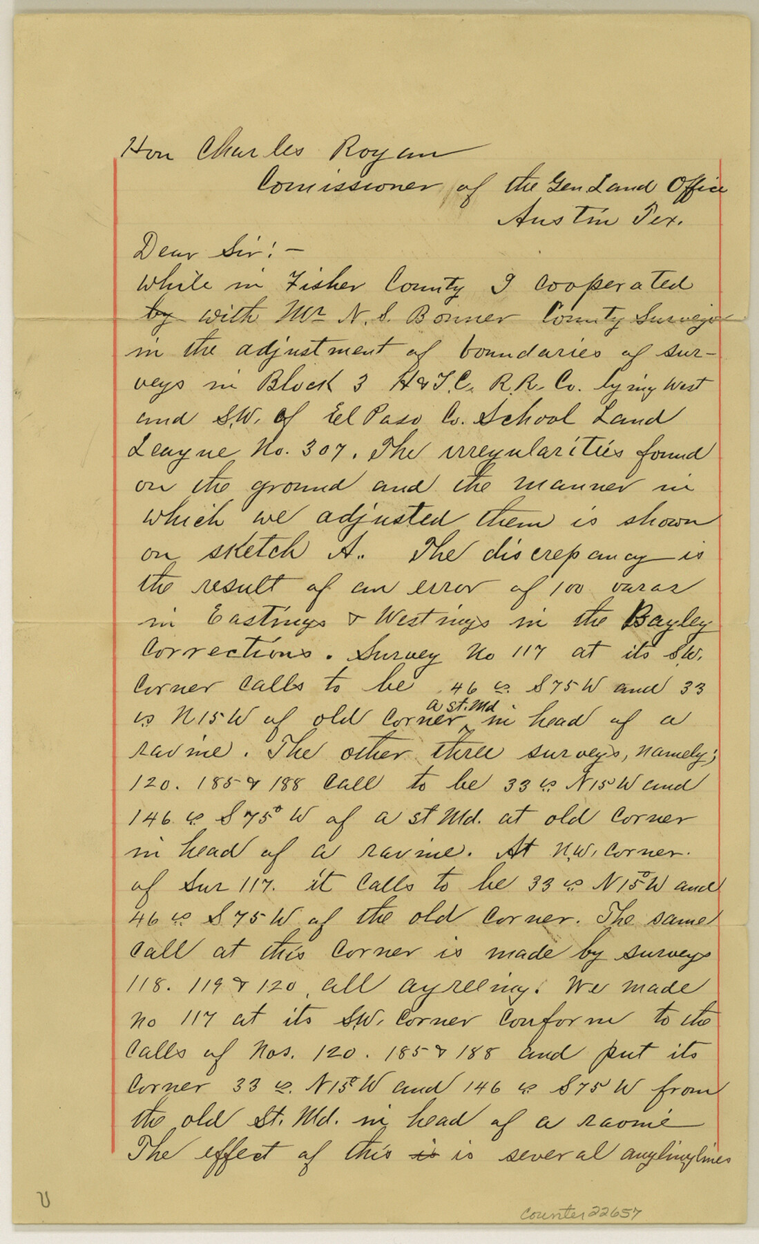
[Surveyor's report and sketch regarding surveys in H. & T. C. R.R. Co. Block 3 and County School Land leagues south and west from Roby]
-
Map/Doc
22657
-
Collection
General Map Collection
-
Object Dates
1/10/1902 (Creation Date)
1/15/1902 (File Date)
-
People and Organizations
George M. Williams (Surveyor/Engineer)
-
Counties
Fisher
-
Subjects
Surveying Sketch File
-
Height x Width
14.3 x 8.7 inches
36.3 x 22.1 cm
-
Medium
paper, manuscript
-
Features
Elm Fork [of the Brazos River]
Cottonwood Creek
Part of: General Map Collection
Hudspeth County Working Sketch 29

Print $40.00
- Digital $50.00
Hudspeth County Working Sketch 29
1972
Size 31.5 x 55.2 inches
Map/Doc 66311
San Augustine County Working Sketch 7

Print $20.00
- Digital $50.00
San Augustine County Working Sketch 7
1935
Size 24.7 x 34.8 inches
Map/Doc 63694
Sutton County Rolled Sketch 52

Print $20.00
- Digital $50.00
Sutton County Rolled Sketch 52
1950
Size 20.8 x 35.2 inches
Map/Doc 7892
Crockett County Working Sketch 49

Print $20.00
- Digital $50.00
Crockett County Working Sketch 49
1938
Size 46.7 x 43.9 inches
Map/Doc 68382
Eastland County Working Sketch 37

Print $20.00
- Digital $50.00
Eastland County Working Sketch 37
1967
Size 23.7 x 18.1 inches
Map/Doc 68818
Flight Mission No. BRA-16M, Frame 102, Jefferson County

Print $20.00
- Digital $50.00
Flight Mission No. BRA-16M, Frame 102, Jefferson County
1953
Size 18.6 x 22.3 inches
Map/Doc 85714
Complete Report of John H. Clark's Survey of Texas-U. S. Boundary - 1859 through 1862, including maps

Print $323.00
Complete Report of John H. Clark's Survey of Texas-U. S. Boundary - 1859 through 1862, including maps
1882
Map/Doc 81685
[Sketch for Mineral Application 16696-16697, Pecos River]
![65613, [Sketch for Mineral Application 16696-16697, Pecos River], General Map Collection](https://historictexasmaps.com/wmedia_w700/maps/65613-1.tif.jpg)
Print $40.00
- Digital $50.00
[Sketch for Mineral Application 16696-16697, Pecos River]
Size 36.7 x 68.3 inches
Map/Doc 65613
[William Steele Survey near Copano Bay]
![60284, [William Steele Survey near Copano Bay], General Map Collection](https://historictexasmaps.com/wmedia_w700/maps/60284-1.tif.jpg)
Print $3.00
- Digital $50.00
[William Steele Survey near Copano Bay]
1927
Size 15.5 x 9.5 inches
Map/Doc 60284
Palo Pinto County Rolled Sketch 14

Print $20.00
- Digital $50.00
Palo Pinto County Rolled Sketch 14
Size 29.7 x 42.5 inches
Map/Doc 7194
Reeves County Sketch File 3

Print $8.00
- Digital $50.00
Reeves County Sketch File 3
Size 14.4 x 8.8 inches
Map/Doc 35188
Brazoria County Working Sketch 26

Print $20.00
- Digital $50.00
Brazoria County Working Sketch 26
1968
Size 33.2 x 35.4 inches
Map/Doc 67511
You may also like

[T. & G. Ry. Main Line, Texas, Right of Way Map, Center to Gary]
![64572, [T. & G. Ry. Main Line, Texas, Right of Way Map, Center to Gary], General Map Collection](https://historictexasmaps.com/wmedia_w700/maps/64572-1.tif.jpg)
Print $40.00
- Digital $50.00
[T. & G. Ry. Main Line, Texas, Right of Way Map, Center to Gary]
1917
Size 31.9 x 104.6 inches
Map/Doc 64572
Pecos County Working Sketch 92

Print $40.00
- Digital $50.00
Pecos County Working Sketch 92
1966
Size 31.4 x 62.2 inches
Map/Doc 71565
Edwards County Working Sketch 76

Print $20.00
- Digital $50.00
Edwards County Working Sketch 76
1959
Size 22.8 x 24.8 inches
Map/Doc 68952
Duval County Working Sketch 57

Print $20.00
- Digital $50.00
Duval County Working Sketch 57
1990
Size 30.3 x 25.4 inches
Map/Doc 68781
General Highway Map, El Paso County, Texas

Print $20.00
General Highway Map, El Paso County, Texas
1961
Size 18.2 x 24.6 inches
Map/Doc 79459
[Block T, Sabine County School Land, and vicinity]
![92250, [Block T, Sabine County School Land, and vicinity], Twichell Survey Records](https://historictexasmaps.com/wmedia_w700/maps/92250-1.tif.jpg)
Print $20.00
- Digital $50.00
[Block T, Sabine County School Land, and vicinity]
Size 35.7 x 32.0 inches
Map/Doc 92250
General Highway Map, San Patricio County, Texas

Print $20.00
General Highway Map, San Patricio County, Texas
1961
Size 18.1 x 24.5 inches
Map/Doc 79647
Henderson County Sketch File 8

Print $6.00
- Digital $50.00
Henderson County Sketch File 8
1853
Size 9.8 x 8.2 inches
Map/Doc 26331
Reconnaissance Map, Roby Sheet

Print $20.00
- Digital $50.00
Reconnaissance Map, Roby Sheet
1893
Size 17.0 x 20.8 inches
Map/Doc 90869
Atascosa County Working Sketch 39

Print $20.00
- Digital $50.00
Atascosa County Working Sketch 39
2011
Size 43.2 x 34.8 inches
Map/Doc 90068
[Block B9 and 3KA]
![90483, [Block B9 and 3KA], Twichell Survey Records](https://historictexasmaps.com/wmedia_w700/maps/90483-1.tif.jpg)
Print $20.00
- Digital $50.00
[Block B9 and 3KA]
Size 23.6 x 16.3 inches
Map/Doc 90483