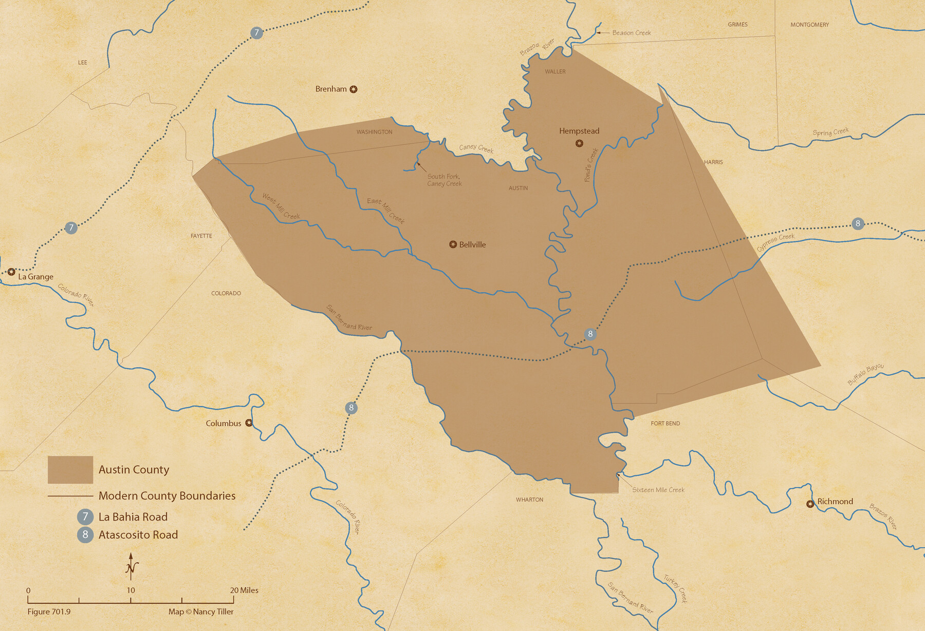
The Republic County of Austin. December 29, 1845
Figure No. 701.9 from 'A Boundary Atlas of Texas, 1821-1845' by Jim Tiller
-
Map/Doc
96088
-
Collection
Nancy and Jim Tiller Digital Collection
-
Object Dates
2020/1/1 (Creation Date)
-
People and Organizations
Jim Tiller (Author)
Nancy Tiller (Cartographer)
Gang Gong (GIS Professional)
-
Counties
Austin
-
Subjects
Atlas County Republic of Texas Texas Boundaries
-
Height x Width
14.7 x 21.6 inches
37.3 x 54.9 cm
-
Medium
digital image
-
Comments
To purchase a digital PDF copy of "A Boundary Atlas of Texas, 1821-1845" see 96437.
Part of: Nancy and Jim Tiller Digital Collection
From Citizens of Nacogdoches County for the Creation of a New County to be Called Smith, September 4, 1841

Print $20.00
From Citizens of Nacogdoches County for the Creation of a New County to be Called Smith, September 4, 1841
2020
Size 18.3 x 21.7 inches
Map/Doc 96392
From Citizens of Nacogdoches County for the Creation of a New County (Unnamed), October 1839

Print $20.00
From Citizens of Nacogdoches County for the Creation of a New County (Unnamed), October 1839
2020
Size 18.2 x 21.7 inches
Map/Doc 96386
The Republic County of Montgomery. January 25, 1840

Print $20.00
The Republic County of Montgomery. January 25, 1840
2020
Size 19.9 x 21.7 inches
Map/Doc 96237
The Republic County of Milam. February 4, 1840

Print $20.00
The Republic County of Milam. February 4, 1840
2020
Size 17.4 x 21.6 inches
Map/Doc 96229
The Republic County of Milam. January 29, 1842

Print $20.00
The Republic County of Milam. January 29, 1842
2020
Size 17.4 x 21.6 inches
Map/Doc 96231
Wavell Empresario Colony. Proposed, March 9, 1826

Print $20.00
Wavell Empresario Colony. Proposed, March 9, 1826
2020
Size 16.0 x 21.7 inches
Map/Doc 96009
The Judicial District/County of Pashcal. Abolished, Spring 1842

Print $20.00
The Judicial District/County of Pashcal. Abolished, Spring 1842
2020
Size 15.0 x 21.7 inches
Map/Doc 96345
The Republic County of Travis. Refined, February 5, 1840

Print $20.00
The Republic County of Travis. Refined, February 5, 1840
2020
Size 20.8 x 21.6 inches
Map/Doc 96290
The Republic County of Montgomery. December 29, 1845

Print $20.00
The Republic County of Montgomery. December 29, 1845
2020
Size 19.9 x 21.7 inches
Map/Doc 96241
The Republic County of Fort Bend. February 4, 1841

Print $20.00
The Republic County of Fort Bend. February 4, 1841
2020
Size 14.7 x 21.6 inches
Map/Doc 96141
The Land Offices. No. 9, Gonzales, December 22, 1836

Print $20.00
The Land Offices. No. 9, Gonzales, December 22, 1836
2020
Size 22.3 x 21.7 inches
Map/Doc 96422
From Citizens to Redefine the Boundary Between Gonzales and Victoria Counties, April 14, 18

Print $20.00
From Citizens to Redefine the Boundary Between Gonzales and Victoria Counties, April 14, 18
2020
Size 24.9 x 21.7 inches
Map/Doc 96378
You may also like
Resurvey of the Original Townsite of Sundown Hockley County, Texas

Print $20.00
- Digital $50.00
Resurvey of the Original Townsite of Sundown Hockley County, Texas
Size 21.7 x 40.3 inches
Map/Doc 92234
[San Antonio & Aransas Pass Through Gonzales County]
![64288, [San Antonio & Aransas Pass Through Gonzales County], General Map Collection](https://historictexasmaps.com/wmedia_w700/maps/64288.tif.jpg)
Print $20.00
- Digital $50.00
[San Antonio & Aransas Pass Through Gonzales County]
1880
Size 11.4 x 30.7 inches
Map/Doc 64288
General Highway Map, Nacogdoches County, Texas

Print $20.00
General Highway Map, Nacogdoches County, Texas
1961
Size 19.3 x 25.0 inches
Map/Doc 79607
[Warren Additions 3 and 4 and vicinity]
![92464, [Warren Additions 3 and 4 and vicinity], Twichell Survey Records](https://historictexasmaps.com/wmedia_w700/maps/92464-1.tif.jpg)
Print $20.00
- Digital $50.00
[Warren Additions 3 and 4 and vicinity]
Size 23.9 x 19.5 inches
Map/Doc 92464
Clay County Working Sketch 6

Print $20.00
- Digital $50.00
Clay County Working Sketch 6
1923
Size 30.0 x 24.1 inches
Map/Doc 68029

Coryell County

Print $20.00
- Digital $50.00
Coryell County
1936
Size 44.5 x 41.2 inches
Map/Doc 73117
Die Neüwen Inseln / so hinder Hispanien gegen Orient bey dem Landt Indie ligen

Print $20.00
- Digital $50.00
Die Neüwen Inseln / so hinder Hispanien gegen Orient bey dem Landt Indie ligen
1540
Size 12.3 x 15.6 inches
Map/Doc 93803
Sketch in Southeast Portion of Stephens County, Texas showing various lines and corners as found upon survey

Print $20.00
- Digital $50.00
Sketch in Southeast Portion of Stephens County, Texas showing various lines and corners as found upon survey
1919
Size 19.2 x 34.3 inches
Map/Doc 91842

Crockett County Working Sketch 76

Print $20.00
- Digital $50.00
Crockett County Working Sketch 76
1964
Size 34.3 x 36.3 inches
Map/Doc 68409
Crosby County Boundary File 5

Print $60.00
- Digital $50.00
Crosby County Boundary File 5
Size 14.3 x 8.8 inches
Map/Doc 52033