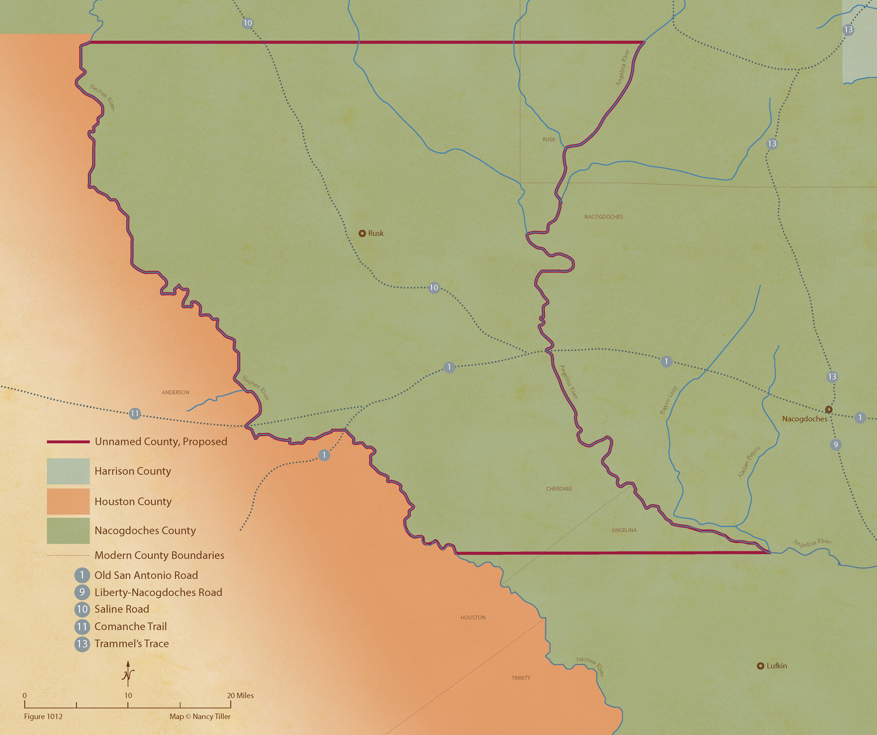
From Citizens of Nacogdoches County for the Creation of a New County (Unnamed), October 1839
Figure No. 1012 from 'A Boundary Atlas of Texas, 1821-1845' by Jim Tiller
- 
                          Map/Doc
96386
 - 
                            Collection
Nancy and Jim Tiller Digital Collection
 - 
                            Object Dates
2020/1/1 (Creation Date)
 - 
                            People and Organizations
Jim Tiller (Author)
Nancy Tiller (Cartographer)
Gang Gong (GIS Professional)
 - 
                            Subjects
Atlas Republic of Texas Texas Boundaries
 - 
                            Height x Width
18.2 x 21.7 inches
46.2 x 55.1 cm
 - 
                            Medium
digital image
 - 
                            Comments
To purchase a digital PDF copy of "A Boundary Atlas of Texas, 1821-1845" see 96437.
 
Part of: Nancy and Jim Tiller Digital Collection
            Authors’ Interpretation of Figure A1029.1, Red River and Shelby Counties, Undated


                                            Print $20.00                    
                                    
                Authors’ Interpretation of Figure A1029.1, Red River and Shelby Counties, Undated
2020
Size 20.1 x 21.7 inches
                                Map/Doc 96404
            
            The Mexican Department of Nacogdoches. Created, January 31, 1831


                                            Print $20.00                    
                                    
                The Mexican Department of Nacogdoches. Created, January 31, 1831
2020
Size 18.4 x 21.7 inches
                                Map/Doc 95972
            
            The Chief Justice County of Bexar. Lands in Conflict with Victoria County


                                            Print $20.00                    
                                    
                The Chief Justice County of Bexar. Lands in Conflict with Victoria County
2020
Size 16.1 x 21.6 inches
                                Map/Doc 96041
            
            From Citizens of Bastrop County for the Creation of a New County (Unnamed), October 1838


                                            Print $20.00                    
                                    
                From Citizens of Bastrop County for the Creation of a New County (Unnamed), October 1838
2020
Size 21.6 x 21.7 inches
                                Map/Doc 96384
            
            The Republic County of Travis. Spring 1842


                                            Print $20.00                    
                                    
                The Republic County of Travis. Spring 1842
2020
Size 20.8 x 21.6 inches
                                Map/Doc 96292
            
            The Republic County of Fort Bend. February 5, 1840


                                            Print $20.00                    
                                    
                The Republic County of Fort Bend. February 5, 1840
2020
Size 14.7 x 21.6 inches
                                Map/Doc 96139
            
            The Republic County of Robertson. November 28, 1839


                                            Print $20.00                    
                                    
                The Republic County of Robertson. November 28, 1839
2020
Size 18.9 x 21.6 inches
                                Map/Doc 96260
            
            The Republic County of Goliad. Boundaries Defined, December 2, 1841


                                            Print $20.00                    
                                    
                The Republic County of Goliad. Boundaries Defined, December 2, 1841
2020
Size 17.5 x 21.7 inches
                                Map/Doc 96151
            
            The Republic County of Montgomery. December 29, 1845


                                            Print $20.00                    
                                    
                The Republic County of Montgomery. December 29, 1845
2020
Size 19.9 x 21.7 inches
                                Map/Doc 96241
            
            The Judicial District/County of Burnet. Abolished, Spring 1842


                                            Print $20.00                    
                                    
                The Judicial District/County of Burnet. Abolished, Spring 1842
2020
Size 19.2 x 21.6 inches
                                Map/Doc 96324
            
            The Republic County of Washington. December 29, 1845


                                            Print $20.00                    
                                    
                The Republic County of Washington. December 29, 1845
2020
Size 11.8 x 21.7 inches
                                Map/Doc 96310
            You may also like
            Clay County Working Sketch 13


                                            Print $20.00                    
                                             -                         Digital $50.00                                    
                Clay County Working Sketch 13
1955
Size 14.7 x 14.3 inches
                                Map/Doc 68036
            
            Fisher County


                                            Print $20.00                    
                                             -                         Digital $50.00                                    
                Fisher County
1921
Size 45.2 x 41.0 inches
                                Map/Doc 16829
            
            Marion County Rolled Sketch 7


                                            Print $20.00                    
                                             -                         Digital $50.00                                    
                Marion County Rolled Sketch 7
Size 13.1 x 30.9 inches
                                Map/Doc 6660
            
            Lavaca County Working Sketch 14


                                            Print $20.00                    
                                             -                         Digital $50.00                                    
                Lavaca County Working Sketch 14
1962
Size 28.4 x 29.7 inches
                                Map/Doc 70367
            
            Brewster County Sketch File NS-11


                                            Print $4.00                    
                                             -                         Digital $50.00                                    
                Brewster County Sketch File NS-11
1948
Size 14.2 x 8.7 inches
                                Map/Doc 16218
            
            [I. &G. N. RR. Co. Block I along Pecos River and other Blocks to the West]


                                            Print $20.00                    
                                             -                         Digital $50.00                                    
                [I. &G. N. RR. Co. Block I along Pecos River and other Blocks to the West]
Size 44.4 x 45.2 inches
                                Map/Doc 89827
            
            Northeast Part of Crockett County


                                            Print $20.00                    
                                             -                         Digital $50.00                                    
                Northeast Part of Crockett County
1976
Size 35.6 x 46.1 inches
                                Map/Doc 73120
            
            Liberty County Working Sketch 45


                                            Print $20.00                    
                                             -                         Digital $50.00                                    
                Liberty County Working Sketch 45
1953
Size 28.9 x 39.8 inches
                                Map/Doc 70504
            
            Flight Mission No. CUG-2P, Frame 66, Kleberg County


                                            Print $20.00                    
                                             -                         Digital $50.00                                    
                Flight Mission No. CUG-2P, Frame 66, Kleberg County
1956
Size 18.5 x 22.2 inches
                                Map/Doc 86203
            
            Eastland County Working Sketch 19


                                            Print $20.00                    
                                             -                         Digital $50.00                                    
                Eastland County Working Sketch 19
1920
Size 15.7 x 16.4 inches
                                Map/Doc 68800
            
            Garza County Boundary File 4


                                            Print $22.00                    
                                             -                         Digital $50.00                                    
                Garza County Boundary File 4
Size 14.5 x 9.0 inches
                                Map/Doc 53698
            
            Gaines County Working Sketch 29


                                            Print $20.00                    
                                             -                         Digital $50.00                                    
                Gaines County Working Sketch 29
1984
Size 32.3 x 42.9 inches
                                Map/Doc 69329