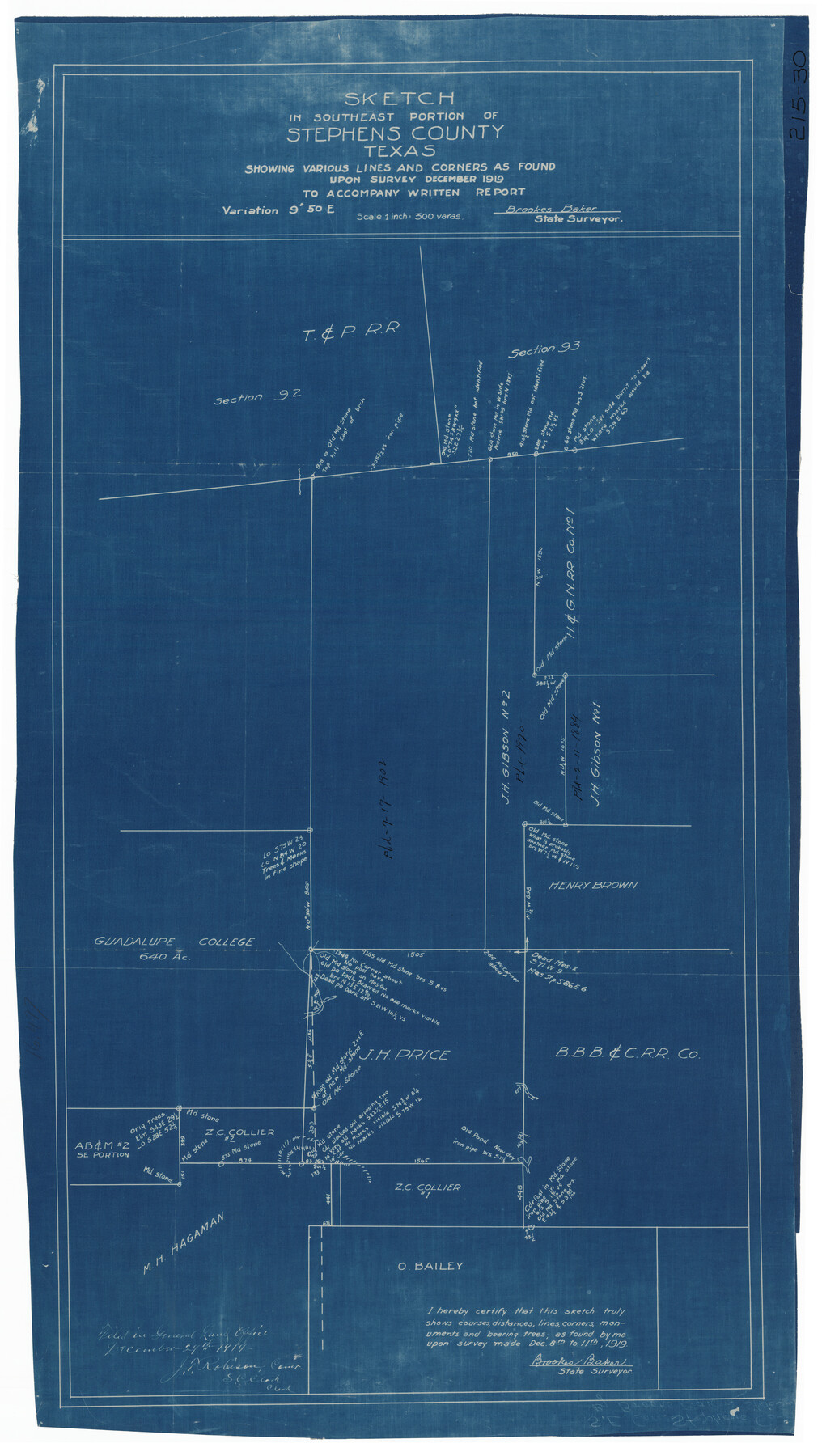
Sketch in Southeast Portion of Stephens County, Texas showing various lines and corners as found upon survey
215-30
-
Map/Doc
91842
-
Collection
Twichell Survey Records
-
Object Dates
12/11/1919 (Creation Date)
-
People and Organizations
Brookes Baker (Surveyor/Engineer)
-
Counties
Stephens
-
Height x Width
19.2 x 34.3 inches
48.8 x 87.1 cm
Part of: Twichell Survey Records
Crockett County, Texas

Print $20.00
- Digital $50.00
Crockett County, Texas
Size 24.7 x 19.5 inches
Map/Doc 90316
[Unknown Connecting Line]
![92040, [Unknown Connecting Line], Twichell Survey Records](https://historictexasmaps.com/wmedia_w700/maps/92040-1.tif.jpg)
Print $20.00
- Digital $50.00
[Unknown Connecting Line]
Size 28.1 x 23.0 inches
Map/Doc 92040
Levelland, Hockley County, Texas

Print $20.00
- Digital $50.00
Levelland, Hockley County, Texas
1950
Size 13.1 x 14.9 inches
Map/Doc 92241
[Part of Connected map of Stephen F. Austin's Colony on file at the GLO]
![90119, [Part of Connected map of Stephen F. Austin's Colony on file at the GLO], Twichell Survey Records](https://historictexasmaps.com/wmedia_w700/maps/90119-1.tif.jpg)
Print $20.00
- Digital $50.00
[Part of Connected map of Stephen F. Austin's Colony on file at the GLO]
1923
Size 18.5 x 18.1 inches
Map/Doc 90119
[Columbus Tap RR. Co. Block 1-A, B. S. & F. Block 1, T. & N. O. Block 7T and vicinity]
![90577, [Columbus Tap RR. Co. Block 1-A, B. S. & F. Block 1, T. & N. O. Block 7T and vicinity], Twichell Survey Records](https://historictexasmaps.com/wmedia_w700/maps/90577-1.tif.jpg)
Print $2.00
- Digital $50.00
[Columbus Tap RR. Co. Block 1-A, B. S. & F. Block 1, T. & N. O. Block 7T and vicinity]
Size 6.1 x 9.6 inches
Map/Doc 90577
Plat of 39 7/10 Acres of Land Owned by W. D. Twichell

Print $2.00
- Digital $50.00
Plat of 39 7/10 Acres of Land Owned by W. D. Twichell
Size 7.1 x 8.1 inches
Map/Doc 92089
[H. & G. N. Block 1]
![90942, [H. & G. N. Block 1], Twichell Survey Records](https://historictexasmaps.com/wmedia_w700/maps/90942-1.tif.jpg)
Print $20.00
- Digital $50.00
[H. & G. N. Block 1]
1873
Size 14.3 x 17.6 inches
Map/Doc 90942
[Lgs. 195-199, 111, 112, 211-214, 678]
![90105, [Lgs. 195-199, 111, 112, 211-214, 678], Twichell Survey Records](https://historictexasmaps.com/wmedia_w700/maps/90105-1.tif.jpg)
Print $20.00
- Digital $50.00
[Lgs. 195-199, 111, 112, 211-214, 678]
Size 16.6 x 13.0 inches
Map/Doc 90105
[Area along West County Line]
![90832, [Area along West County Line], Twichell Survey Records](https://historictexasmaps.com/wmedia_w700/maps/90832-2.tif.jpg)
Print $2.00
- Digital $50.00
[Area along West County Line]
Size 6.0 x 9.6 inches
Map/Doc 90832
[Township 3 North, Block 33]
![91215, [Township 3 North, Block 33], Twichell Survey Records](https://historictexasmaps.com/wmedia_w700/maps/91215-1.tif.jpg)
Print $3.00
- Digital $50.00
[Township 3 North, Block 33]
Size 11.2 x 17.0 inches
Map/Doc 91215
[Washington County RR. Co. Block 1 and Cherokee Iron Furnace Co. Block 1]
![92065, [Washington County RR. Co. Block 1 and Cherokee Iron Furnace Co. Block 1], Twichell Survey Records](https://historictexasmaps.com/wmedia_w700/maps/92065-1.tif.jpg)
Print $20.00
- Digital $50.00
[Washington County RR. Co. Block 1 and Cherokee Iron Furnace Co. Block 1]
1911
Size 22.4 x 25.4 inches
Map/Doc 92065
Working Sketch, Garza County

Print $20.00
- Digital $50.00
Working Sketch, Garza County
1904
Size 13.9 x 14.7 inches
Map/Doc 92693
You may also like
Kimble County Working Sketch 10

Print $20.00
- Digital $50.00
Kimble County Working Sketch 10
1921
Size 14.7 x 15.5 inches
Map/Doc 70078
Haskell County Sketch File 1

Print $20.00
- Digital $50.00
Haskell County Sketch File 1
1856
Size 19.9 x 10.6 inches
Map/Doc 11738
Irion County Rolled Sketch 9

Print $20.00
- Digital $50.00
Irion County Rolled Sketch 9
1940
Size 31.9 x 30.6 inches
Map/Doc 6321
General Highway Map, Hood County, Somervell County, Texas

Print $20.00
General Highway Map, Hood County, Somervell County, Texas
1940
Size 18.3 x 24.8 inches
Map/Doc 79131
Kendall County Sketch File 18

Print $4.00
- Digital $50.00
Kendall County Sketch File 18
1882
Size 10.0 x 6.7 inches
Map/Doc 28711
Flight Mission No. BRA-6T, Frame 117, Jefferson County

Print $20.00
- Digital $50.00
Flight Mission No. BRA-6T, Frame 117, Jefferson County
1957
Size 18.6 x 18.4 inches
Map/Doc 85786
Sketch in Dawson County, Texas

Print $3.00
- Digital $50.00
Sketch in Dawson County, Texas
1950
Size 9.5 x 12.8 inches
Map/Doc 92627
The Judicial District/County of Waco. Abolished, Spring 1842

Print $20.00
The Judicial District/County of Waco. Abolished, Spring 1842
2020
Size 16.2 x 21.7 inches
Map/Doc 96353
[Canadian River North]
![91826, [Canadian River North], Twichell Survey Records](https://historictexasmaps.com/wmedia_w700/maps/91826-1.tif.jpg)
Print $3.00
- Digital $50.00
[Canadian River North]
Size 17.9 x 11.7 inches
Map/Doc 91826
Brewster County Working Sketch 74

Print $20.00
- Digital $50.00
Brewster County Working Sketch 74
1966
Size 24.8 x 32.0 inches
Map/Doc 67674
[Surveys along the Trinity River]
![350, [Surveys along the Trinity River], General Map Collection](https://historictexasmaps.com/wmedia_w700/maps/350.tif.jpg)
Print $20.00
- Digital $50.00
[Surveys along the Trinity River]
1846
Size 12.6 x 14.7 inches
Map/Doc 350
Flight Mission No. DIX-10P, Frame 166, Aransas County

Print $20.00
- Digital $50.00
Flight Mission No. DIX-10P, Frame 166, Aransas County
1956
Size 18.5 x 22.2 inches
Map/Doc 83956