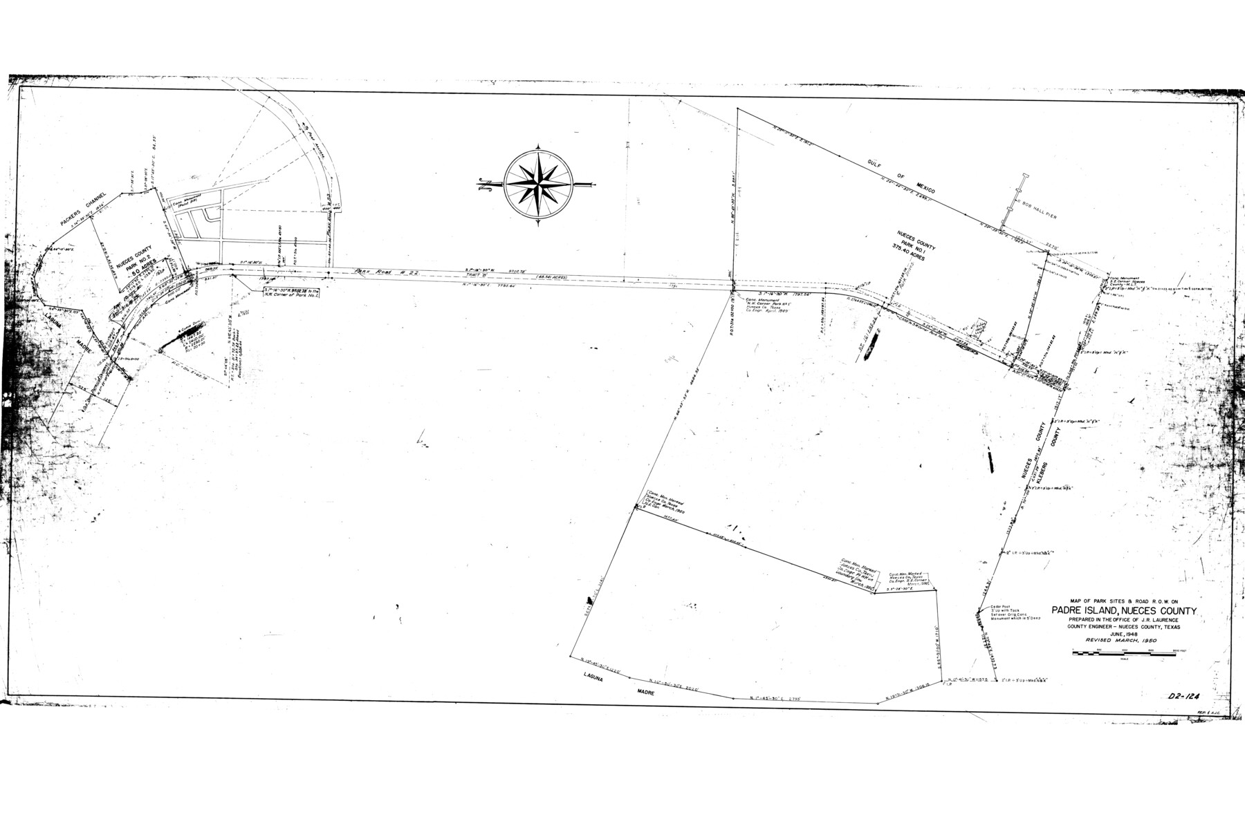
Nueces County Rolled Sketch 44
Map of park sites & road R.O.W. on Padre Island, Nueces County
- 
                          Map/Doc
9602
 - 
                            Collection
General Map Collection
 - 
                            Object Dates
6/1948 (Creation Date)
10/7/1974 (File Date)
3/1950 (Revision Date)
 - 
                            People and Organizations
J.R. Laurence (Surveyor/Engineer)
 - 
                            Counties
Nueces
 - 
                            Subjects
Surveying Rolled Sketch
 - 
                            Height x Width
40.0 x 60.8 inches
101.6 x 154.4 cm
 
Part of: General Map Collection
            Presidio County Sketch File 58a


                                            Print $14.00                    
                                             -                         Digital $50.00                                    
                Presidio County Sketch File 58a
1980
Size 11.2 x 8.8 inches
                                Map/Doc 34628
            
            King County Working Sketch 14


                                            Print $20.00                    
                                             -                         Digital $50.00                                    
                King County Working Sketch 14
1979
Size 27.7 x 32.5 inches
                                Map/Doc 70178
            
            Tarrant's Key and Guide to Dallas


                                            Print $3.00                    
                                             -                         Digital $50.00                                    
                Tarrant's Key and Guide to Dallas
1922
Size 7.9 x 10.4 inches
                                Map/Doc 89257
            
            Refugio County Boundary File 1 (2)


                                            Print $6.00                    
                                             -                         Digital $50.00                                    
                Refugio County Boundary File 1 (2)
Size 12.6 x 8.7 inches
                                Map/Doc 58228
            
            Flight Mission No. DIX-8P, Frame 57, Aransas County


                                            Print $20.00                    
                                             -                         Digital $50.00                                    
                Flight Mission No. DIX-8P, Frame 57, Aransas County
1956
Size 18.7 x 22.4 inches
                                Map/Doc 83888
            
            Map of Tom Green County


                                            Print $20.00                    
                                             -                         Digital $50.00                                    
                Map of Tom Green County
1892
Size 44.0 x 45.1 inches
                                Map/Doc 63068
            
            State Reclamation Department - An Index Map


                                            Print $40.00                    
                                             -                         Digital $50.00                                    
                State Reclamation Department - An Index Map
1930
Size 50.1 x 31.8 inches
                                Map/Doc 65267
            
            Webb County Working Sketch 47


                                            Print $20.00                    
                                             -                         Digital $50.00                                    
                Webb County Working Sketch 47
1948
Size 35.9 x 36.2 inches
                                Map/Doc 72412
            
            Montague County Sketch File 24


                                            Print $20.00                    
                                             -                         Digital $50.00                                    
                Montague County Sketch File 24
1941
Size 16.2 x 23.3 inches
                                Map/Doc 12108
            
            [Map of Polk County]


                                            Print $20.00                    
                                             -                         Digital $50.00                                    
                [Map of Polk County]
1855
Size 21.2 x 31.0 inches
                                Map/Doc 4613
            
            [Missouri, Kansas & Texas Line Map through Bastrop County]


                                            Print $40.00                    
                                             -                         Digital $50.00                                    
                [Missouri, Kansas & Texas Line Map through Bastrop County]
1916
Size 26.5 x 124.4 inches
                                Map/Doc 64031
            
            Harris County Aerial Photograph Index Sheet 9


                                            Print $20.00                    
                                             -                         Digital $50.00                                    
                Harris County Aerial Photograph Index Sheet 9
1953
Size 22.1 x 16.6 inches
                                Map/Doc 83703
            You may also like
            Chart of Aransas Harbor


                                            Print $20.00                    
                                    
                Chart of Aransas Harbor
1859
Size 14.2 x 17.4 inches
                                Map/Doc 76292
            
            Concho, San Saba & Llano Valley Railway, Sterling City Branch, Texas. Right of Way and Track Map


                                            Print $40.00                    
                                             -                         Digital $50.00                                    
                Concho, San Saba & Llano Valley Railway, Sterling City Branch, Texas. Right of Way and Track Map
1910
Size 17.7 x 57.8 inches
                                Map/Doc 64437
            
            The Republic County of Goliad. Proposed, Late Fall 1837-December 31, 1838


                                            Print $20.00                    
                                    
                The Republic County of Goliad. Proposed, Late Fall 1837-December 31, 1838
2020
Size 15.1 x 21.7 inches
                                Map/Doc 96148
            
            Galveston County Rolled Sketch 44


                                            Print $20.00                    
                                             -                         Digital $50.00                                    
                Galveston County Rolled Sketch 44
1991
Size 25.1 x 36.8 inches
                                Map/Doc 5974
            
            Sketch Showing all that Portion of Block 24 North of Santa Fe R. R. Right-of-Way in Original Town of Lubbock


                                            Print $20.00                    
                                             -                         Digital $50.00                                    
                Sketch Showing all that Portion of Block 24 North of Santa Fe R. R. Right-of-Way in Original Town of Lubbock
1925
Size 27.5 x 35.6 inches
                                Map/Doc 92810
            
            Terrell County Working Sketch 22


                                            Print $20.00                    
                                             -                         Digital $50.00                                    
                Terrell County Working Sketch 22
1937
Size 28.8 x 26.5 inches
                                Map/Doc 62172
            
            Milam County Boundary File 6a


                                            Print $20.00                    
                                             -                         Digital $50.00                                    
                Milam County Boundary File 6a
Size 9.5 x 29.0 inches
                                Map/Doc 57248
            
            Cherokee County Working Sketch Graphic Index


                                            Print $40.00                    
                                             -                         Digital $50.00                                    
                Cherokee County Working Sketch Graphic Index
1933
Size 56.7 x 40.0 inches
                                Map/Doc 76492
            
            Presidio County Rolled Sketch T-1


                                            Print $20.00                    
                                             -                         Digital $50.00                                    
                Presidio County Rolled Sketch T-1
Size 26.8 x 27.1 inches
                                Map/Doc 7416
            
            [Capitol Leagues 217, 218, 219 and 220]


                                            Print $20.00                    
                                             -                         Digital $50.00                                    
                [Capitol Leagues 217, 218, 219 and 220]
Size 23.2 x 10.3 inches
                                Map/Doc 91460
            
            General Highway Map.  Detail of Cities and Towns in Travis County, Texas.  City Map, Austin and vicinity, Travis County, Texas


                                            Print $20.00                    
                                    
                General Highway Map. Detail of Cities and Towns in Travis County, Texas. City Map, Austin and vicinity, Travis County, Texas
1961
Size 18.2 x 24.9 inches
                                Map/Doc 79684