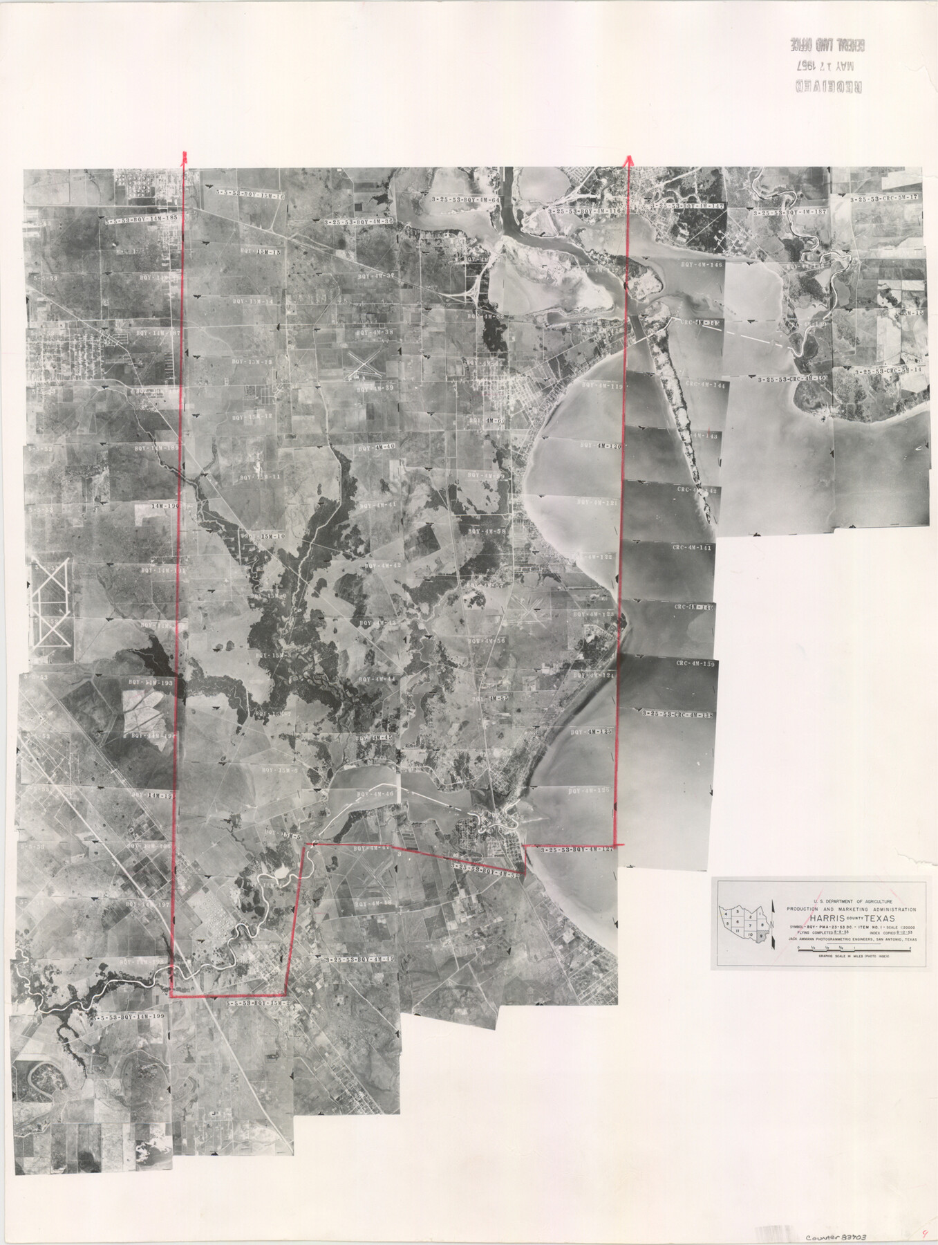
Harris County Aerial Photograph Index Sheet 9
Harris County Aerial Photograph Index 9
-
Map/Doc
83703
-
Collection
General Map Collection
-
Object Dates
1953/8/12 (Creation Date)
-
People and Organizations
U. S. Department of Agriculture (Publisher)
-
Counties
Harris
-
Subjects
Aerial Photograph
-
Height x Width
22.1 x 16.6 inches
56.1 x 42.2 cm
-
Comments
Flying completed August 8, 1953 by Jack Ammann Photogrammetric Engineers of San Antonio, Texas.
Received in office May 17, 1957.
Part of: General Map Collection
Freestone County Rolled Sketch 13B

Print $20.00
- Digital $50.00
Freestone County Rolled Sketch 13B
1989
Size 25.2 x 20.5 inches
Map/Doc 5915
Jefferson County Rolled Sketch 24

Print $20.00
- Digital $50.00
Jefferson County Rolled Sketch 24
1940
Size 30.3 x 27.8 inches
Map/Doc 6388
Leon County Working Sketch 28

Print $20.00
- Digital $50.00
Leon County Working Sketch 28
1971
Size 25.0 x 30.1 inches
Map/Doc 70427
Milam County Sketch File 3

Print $4.00
- Digital $50.00
Milam County Sketch File 3
1853
Size 12.9 x 8.1 inches
Map/Doc 31628
Montgomery County Texas Historical Map

Montgomery County Texas Historical Map
Size 23.2 x 35.3 inches
Map/Doc 94404
Menard County Rolled Sketch 18

Print $20.00
- Digital $50.00
Menard County Rolled Sketch 18
2024
Size 35.9 x 47.7 inches
Map/Doc 97427
Terrell County Working Sketch 39

Print $20.00
- Digital $50.00
Terrell County Working Sketch 39
1951
Size 26.8 x 40.4 inches
Map/Doc 62132
Culberson County Working Sketch 19

Print $20.00
- Digital $50.00
Culberson County Working Sketch 19
1933
Size 30.0 x 43.6 inches
Map/Doc 68471
Baylor County Sketch File 19

Print $4.00
- Digital $50.00
Baylor County Sketch File 19
1885
Size 11.5 x 8.8 inches
Map/Doc 14193

Pecos County Sketch File 14A

Print $20.00
- Digital $50.00
Pecos County Sketch File 14A
Size 33.7 x 23.0 inches
Map/Doc 12158
Galveston County NRC Article 33.136 Sketch 55A

Print $28.00
- Digital $50.00
Galveston County NRC Article 33.136 Sketch 55A
2009
Size 24.0 x 36.0 inches
Map/Doc 94616
You may also like
Goliad County Sketch File 42

Print $8.00
- Digital $50.00
Goliad County Sketch File 42
1847
Size 13.0 x 8.2 inches
Map/Doc 24349
That part of Disturnell's Treaty Map in the Vicinity of the Rio Grande and Southern Boundary of New Mexico

Print $20.00
- Digital $50.00
That part of Disturnell's Treaty Map in the Vicinity of the Rio Grande and Southern Boundary of New Mexico
1851
Size 10.7 x 12.5 inches
Map/Doc 97140
Map of a part of Laguna Madre showing subdivision for mineral development

Print $20.00
- Digital $50.00
Map of a part of Laguna Madre showing subdivision for mineral development
1948
Size 42.9 x 31.0 inches
Map/Doc 2913
East Half of Section 58. W. C. RR. Co. Block 3

Print $20.00
- Digital $50.00
East Half of Section 58. W. C. RR. Co. Block 3
1952
Size 8.7 x 18.8 inches
Map/Doc 92594

Trinity County Sketch File 33A

Print $6.00
- Digital $50.00
Trinity County Sketch File 33A
1920
Size 6.5 x 6.8 inches
Map/Doc 38575
Hidalgo County Sketch File 12

Print $20.00
- Digital $50.00
Hidalgo County Sketch File 12
Size 16.3 x 25.1 inches
Map/Doc 11763
Chambers County Working Sketch 6

Print $20.00
- Digital $50.00
Chambers County Working Sketch 6
1938
Size 14.3 x 19.7 inches
Map/Doc 67989
[Edwards County]
![4940, [Edwards County], General Map Collection](https://historictexasmaps.com/wmedia_w700/maps/4940-1.tif.jpg)
Print $40.00
- Digital $50.00
[Edwards County]
1900
Size 48.7 x 32.7 inches
Map/Doc 4940
Starr County Sketch File 30A

Print $20.00
- Digital $50.00
Starr County Sketch File 30A
1935
Size 21.2 x 23.6 inches
Map/Doc 12334
Sutton County Sketch File 61

Print $14.00
- Digital $50.00
Sutton County Sketch File 61
1986
Size 11.2 x 8.9 inches
Map/Doc 37557
Flight Mission No. BQR-13K, Frame 166, Brazoria County

Print $20.00
- Digital $50.00
Flight Mission No. BQR-13K, Frame 166, Brazoria County
1952
Size 18.8 x 22.3 inches
Map/Doc 84091