Mason County Sketch File 3a
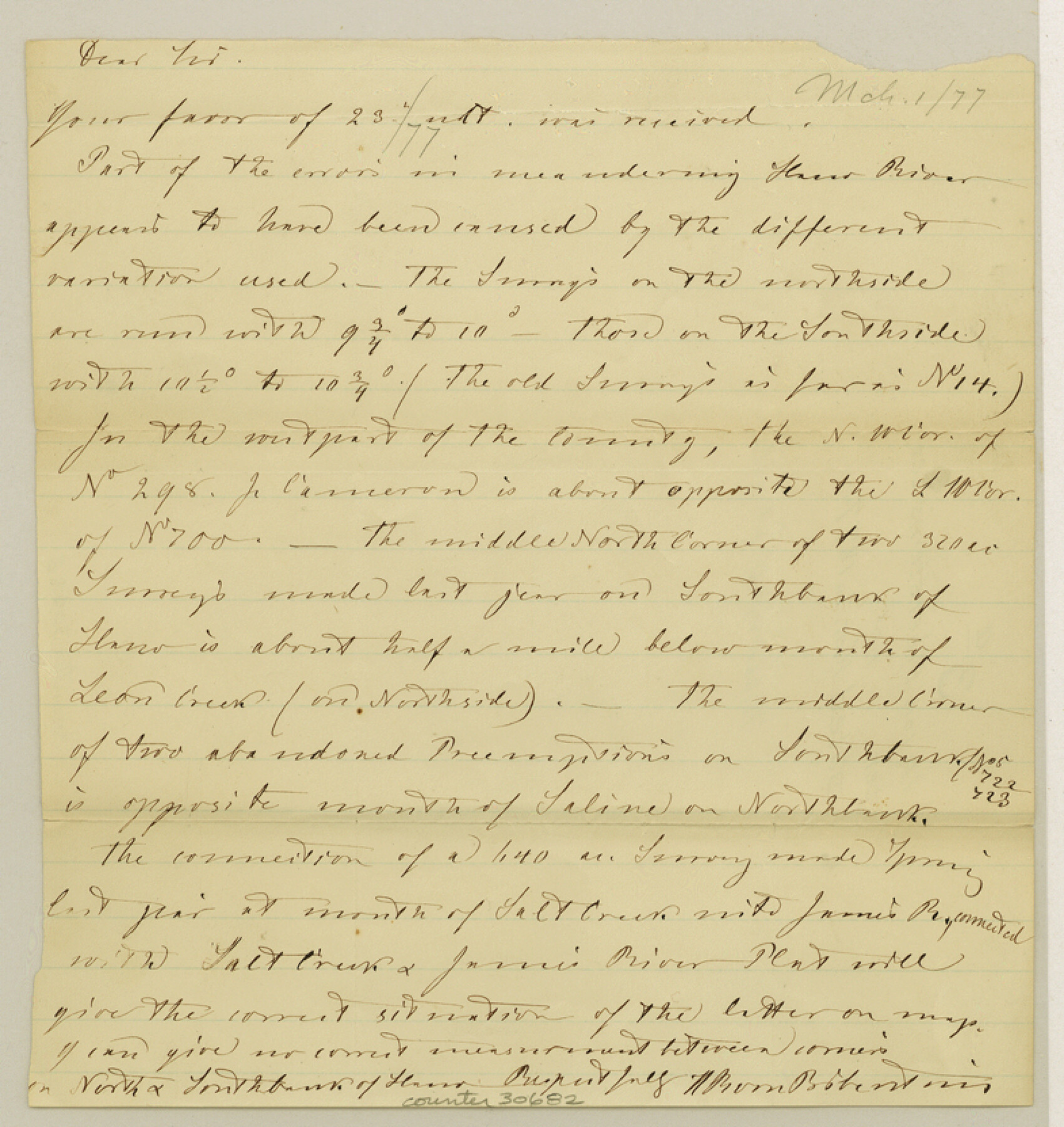
[Letter regarding locations of surveys affected by errors in meandering the Llano River]
-
Map/Doc
30682
-
Collection
General Map Collection
-
Object Dates
4/1/1877 (Creation Date)
-
People and Organizations
H.R. von Biberstein (Surveyor/Engineer)
-
Counties
Mason
-
Subjects
Surveying Sketch File
-
Height x Width
8.3 x 7.9 inches
21.1 x 20.1 cm
-
Medium
paper, manuscript
-
Features
Llano River
Saline Creek
Leon Creek
Salt Creek
James River
Part of: General Map Collection
Runnels County Sketch File 41

Print $20.00
Runnels County Sketch File 41
1892
Size 22.8 x 25.7 inches
Map/Doc 12271
Flight Mission No. DAG-17K, Frame 126, Matagorda County

Print $20.00
- Digital $50.00
Flight Mission No. DAG-17K, Frame 126, Matagorda County
1952
Size 18.6 x 22.3 inches
Map/Doc 86346
Flight Mission No. BRA-7M, Frame 199, Jefferson County

Print $20.00
- Digital $50.00
Flight Mission No. BRA-7M, Frame 199, Jefferson County
1953
Size 18.7 x 22.4 inches
Map/Doc 85567
Pecos County Rolled Sketch 178

Print $20.00
- Digital $50.00
Pecos County Rolled Sketch 178
1979
Size 38.5 x 28.7 inches
Map/Doc 7298
Pecos County Sketch File 105

Print $4.00
- Digital $50.00
Pecos County Sketch File 105
1965
Size 14.3 x 8.8 inches
Map/Doc 34028
Brewster County Rolled Sketch 154

Print $20.00
- Digital $50.00
Brewster County Rolled Sketch 154
2001
Size 36.3 x 28.0 inches
Map/Doc 5325
Padre Island National Seashore, Texas - Dependent Resurvey

Print $4.00
- Digital $50.00
Padre Island National Seashore, Texas - Dependent Resurvey
2001
Size 18.3 x 24.2 inches
Map/Doc 60546
Hudspeth County Sketch File 24

Print $20.00
- Digital $50.00
Hudspeth County Sketch File 24
1936
Size 17.8 x 16.7 inches
Map/Doc 11802
United States - Gulf Coast - From Latitude 26° 33' to the Rio Grande Texas

Print $20.00
- Digital $50.00
United States - Gulf Coast - From Latitude 26° 33' to the Rio Grande Texas
1913
Size 27.9 x 18.4 inches
Map/Doc 72834
Robertson County Sketch File 12

Print $18.00
Robertson County Sketch File 12
1987
Size 11.4 x 8.8 inches
Map/Doc 35404
Webb County Sketch File 66

Print $20.00
- Digital $50.00
Webb County Sketch File 66
1950
Size 13.4 x 20.6 inches
Map/Doc 12655
Midland County Rolled Sketch 9

Print $40.00
- Digital $50.00
Midland County Rolled Sketch 9
Size 73.4 x 17.3 inches
Map/Doc 6766
You may also like
Cooke County Working Sketch 24

Print $20.00
- Digital $50.00
Cooke County Working Sketch 24
1972
Size 22.1 x 24.4 inches
Map/Doc 68261
Southern Part of Laguna Madre
Print $20.00
- Digital $50.00
Southern Part of Laguna Madre
1949
Size 33.8 x 26.7 inches
Map/Doc 73536
[John Durst's grant along the Trinity River]
![185, [John Durst's grant along the Trinity River], General Map Collection](https://historictexasmaps.com/wmedia_w700/maps/185.tif.jpg)
Print $2.00
- Digital $50.00
[John Durst's grant along the Trinity River]
Size 12.3 x 8.2 inches
Map/Doc 185
Kimble County Working Sketch 10

Print $20.00
- Digital $50.00
Kimble County Working Sketch 10
1921
Size 14.7 x 15.5 inches
Map/Doc 70078
Roberts County Boundary File 2

Print $12.00
- Digital $50.00
Roberts County Boundary File 2
Size 9.9 x 6.4 inches
Map/Doc 58333
Dallas County Working Sketch 19

Print $20.00
- Digital $50.00
Dallas County Working Sketch 19
1997
Size 23.1 x 30.3 inches
Map/Doc 68585
Flight Mission No. CGN-3P, Frame 141, San Patricio County

Print $20.00
- Digital $50.00
Flight Mission No. CGN-3P, Frame 141, San Patricio County
1956
Size 18.6 x 22.4 inches
Map/Doc 86985
Foard County Boundary File 5a

Print $40.00
- Digital $50.00
Foard County Boundary File 5a
Size 18.2 x 44.4 inches
Map/Doc 53546
Flight Mission No. DCL-7C, Frame 24, Kenedy County

Print $20.00
- Digital $50.00
Flight Mission No. DCL-7C, Frame 24, Kenedy County
1943
Size 15.5 x 15.4 inches
Map/Doc 86016
[Field book of Martin Duval, Wilbarger Co., H&TC RR Co. Blocks 13 & 14]
![61431, [Field book of Martin Duval, Wilbarger Co., H&TC RR Co. Blocks 13 & 14], General Map Collection](https://historictexasmaps.com/wmedia_w700/pdf_converted_jpg/qi_pdf_thumbnail_17161.jpg)
[Field book of Martin Duval, Wilbarger Co., H&TC RR Co. Blocks 13 & 14]
Size 6.7 x 8.2 inches
Map/Doc 61431
Denton County Sketch File 14

Print $10.00
- Digital $50.00
Denton County Sketch File 14
1855
Size 8.6 x 10.0 inches
Map/Doc 20719
Flight Mission No. DAG-21K, Frame 38, Matagorda County

Print $20.00
- Digital $50.00
Flight Mission No. DAG-21K, Frame 38, Matagorda County
1952
Size 18.6 x 22.3 inches
Map/Doc 86405