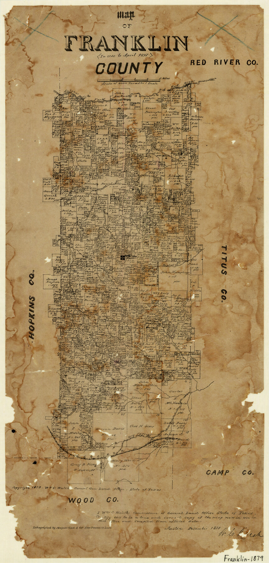
Map of Franklin County
-
Map/Doc
3560
-
Collection
General Map Collection
-
Object Dates
12/1879 (Creation Date)
-
People and Organizations
W.C. Walsh (GLO Commissioner)
August Gast & Co. (Lithographer)
-
Counties
Franklin
-
Subjects
County
-
Height x Width
21.1 x 10.4 inches
53.6 x 26.4 cm
-
Comments
Note on map: "In use to April 1897".
Copyrighted 1879. -
Features
Bear Creek
EL&RR
Dry Cypress Creek
Andy's Creek
Glade Creek
Mountain Creek
Panther Creek
Smith's Creek
Cedar Creek
Blair's Creek
Sulphur Fork of the Red River
Blundell's Creek
Ripley's Creek
Mount Vernon
Timber Creek
Pecan Branch [of Prairie Creek]
Prairie Creek
Campbell's Creek
Guest's Creek
Whiteoak Branch [of Cypress Creek]
Part of: General Map Collection
Hoffman & Walker's Pictorial, Historical Map of Texas

Hoffman & Walker's Pictorial, Historical Map of Texas
1960
Size 44.0 x 45.5 inches
Map/Doc 2122
Hamilton County Boundary File 6

Print $4.00
- Digital $50.00
Hamilton County Boundary File 6
Size 11.2 x 8.6 inches
Map/Doc 54225
[Sketch for Mineral Application 27670 - Strip between Simon Sanchez leagues and Trinity River]
![65646, [Sketch for Mineral Application 27670 - Strip between Simon Sanchez leagues and Trinity River], General Map Collection](https://historictexasmaps.com/wmedia_w700/maps/65646.tif.jpg)
Print $40.00
- Digital $50.00
[Sketch for Mineral Application 27670 - Strip between Simon Sanchez leagues and Trinity River]
Size 55.5 x 17.8 inches
Map/Doc 65646

Limestone County Sketch File 15

Print $8.00
- Digital $50.00
Limestone County Sketch File 15
1883
Size 12.7 x 8.0 inches
Map/Doc 30181
Flight Mission No. BQR-16K, Frame 33, Brazoria County

Print $20.00
- Digital $50.00
Flight Mission No. BQR-16K, Frame 33, Brazoria County
1952
Size 18.5 x 22.3 inches
Map/Doc 84100
Map of Ramon Musquiz Survey, Meanders of Lavaca & Navidad Rivers, Menefee & Redfish Lakes

Print $20.00
- Digital $50.00
Map of Ramon Musquiz Survey, Meanders of Lavaca & Navidad Rivers, Menefee & Redfish Lakes
1934
Size 23.4 x 18.4 inches
Map/Doc 65455
Schleicher County Sketch File 4

Print $20.00
- Digital $50.00
Schleicher County Sketch File 4
Size 18.8 x 16.1 inches
Map/Doc 12296
Flight Mission No. CRC-3R, Frame 29, Chambers County

Print $20.00
- Digital $50.00
Flight Mission No. CRC-3R, Frame 29, Chambers County
1956
Size 18.6 x 22.3 inches
Map/Doc 84804
Padre Island National Seashore, Texas - Dependent Resurvey

Print $2.00
- Digital $50.00
Padre Island National Seashore, Texas - Dependent Resurvey
Size 11.5 x 8.3 inches
Map/Doc 60542
Montgomery County Sketch File 9

Print $6.00
- Digital $50.00
Montgomery County Sketch File 9
Size 9.0 x 7.6 inches
Map/Doc 31795
Camp County Working Sketch 3

Print $20.00
- Digital $50.00
Camp County Working Sketch 3
1982
Size 32.1 x 24.4 inches
Map/Doc 67879
You may also like
Yoakum County Rolled Sketch 3(2)

Print $40.00
- Digital $50.00
Yoakum County Rolled Sketch 3(2)
1959
Size 12.7 x 128.8 inches
Map/Doc 10163
Map of the State of Texas Showing Original Land Districts

Print $20.00
- Digital $50.00
Map of the State of Texas Showing Original Land Districts
1891
Size 45.6 x 43.0 inches
Map/Doc 1995
C.C. Slaughter's Running Water Ranch situated in Hale and Lamb Counties

Print $20.00
- Digital $50.00
C.C. Slaughter's Running Water Ranch situated in Hale and Lamb Counties
Size 26.5 x 18.8 inches
Map/Doc 91050
Map of the River Sabine from Logan's Ferry to 32nd degree of North Latitude

Print $20.00
- Digital $50.00
Map of the River Sabine from Logan's Ferry to 32nd degree of North Latitude
Size 22.1 x 28.6 inches
Map/Doc 94002
Dawson County Sketch File 30

Print $40.00
- Digital $50.00
Dawson County Sketch File 30
1913
Size 13.6 x 9.1 inches
Map/Doc 20594
Presidio County Working Sketch 18

Print $20.00
- Digital $50.00
Presidio County Working Sketch 18
1943
Size 26.0 x 25.4 inches
Map/Doc 71694
[State Line from Southeast New Mexico to Yoakum County]
![92013, [State Line from Southeast New Mexico to Yoakum County], Twichell Survey Records](https://historictexasmaps.com/wmedia_w700/maps/92013-1.tif.jpg)
Print $20.00
- Digital $50.00
[State Line from Southeast New Mexico to Yoakum County]
Size 32.3 x 11.7 inches
Map/Doc 92013
Kendall County Sketch File 13

Print $4.00
- Digital $50.00
Kendall County Sketch File 13
1860
Size 10.1 x 8.0 inches
Map/Doc 28699
Culberson County Rolled Sketch 20

Print $20.00
- Digital $50.00
Culberson County Rolled Sketch 20
1912
Size 30.0 x 18.2 inches
Map/Doc 5653
Boundary Between the United States & Mexico Agreed upon by the Joint Commission under the Treaty of Guadalupe Hidalgo

Print $4.00
- Digital $50.00
Boundary Between the United States & Mexico Agreed upon by the Joint Commission under the Treaty of Guadalupe Hidalgo
1853
Size 18.3 x 26.8 inches
Map/Doc 72881
Pecos County Rolled Sketch 155

Print $40.00
- Digital $50.00
Pecos County Rolled Sketch 155
Size 65.1 x 44.8 inches
Map/Doc 9737
[Sketch showing G. & M. Blocks 5 and M-19 and B. S. & F. Block 9]
![91718, [Sketch showing G. & M. Blocks 5 and M-19 and B. S. & F. Block 9], Twichell Survey Records](https://historictexasmaps.com/wmedia_w700/maps/91718-1.tif.jpg)
Print $20.00
- Digital $50.00
[Sketch showing G. & M. Blocks 5 and M-19 and B. S. & F. Block 9]
Size 22.9 x 17.4 inches
Map/Doc 91718