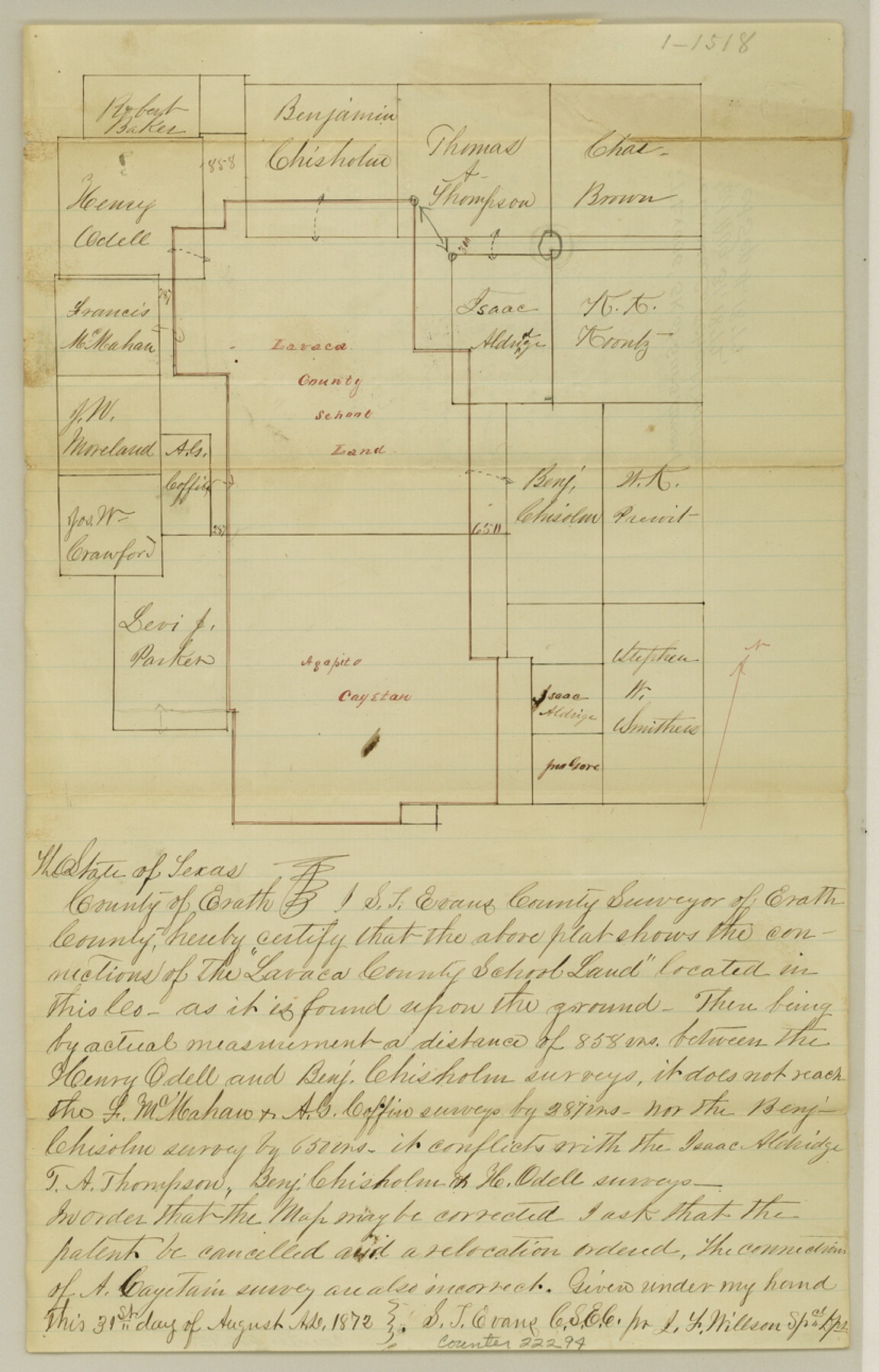
Erath County Sketch File 16
[Sketch of surveys around the Lavaca County School Land survey]
-
Map/Doc
22294
-
Collection
General Map Collection
-
Object Dates
1872/8/31 (Creation Date)
1872/9/4 (File Date)
-
People and Organizations
S.T. Evans (Surveyor/Engineer)
-
Counties
Erath
-
Subjects
Surveying Sketch File
-
Height x Width
12.9 x 8.3 inches
32.8 x 21.1 cm
-
Medium
paper, manuscript
Part of: General Map Collection
Tyler County Sketch File 18

Print $4.00
- Digital $50.00
Tyler County Sketch File 18
1879
Size 8.2 x 8.7 inches
Map/Doc 38668
Runnels County Sketch File 6a

Print $4.00
Runnels County Sketch File 6a
1883
Size 12.9 x 8.2 inches
Map/Doc 35442
Map of Jasper County

Print $40.00
- Digital $50.00
Map of Jasper County
1898
Size 48.6 x 39.2 inches
Map/Doc 4990
Red River County Working Sketch 48

Print $20.00
- Digital $50.00
Red River County Working Sketch 48
1970
Size 28.6 x 30.2 inches
Map/Doc 72031
Hamilton County Boundary File 6

Print $4.00
- Digital $50.00
Hamilton County Boundary File 6
Size 11.2 x 8.6 inches
Map/Doc 54225
Edwards County Rolled Sketch 18

Print $20.00
- Digital $50.00
Edwards County Rolled Sketch 18
1947
Size 21.8 x 21.2 inches
Map/Doc 5807
Archer County Sketch File 26

Print $4.00
- Digital $50.00
Archer County Sketch File 26
1934
Size 9.7 x 4.4 inches
Map/Doc 13663
Kinney County Working Sketch 22

Print $20.00
- Digital $50.00
Kinney County Working Sketch 22
1950
Size 46.5 x 37.2 inches
Map/Doc 70204
Val Verde County Sketch File Z7

Print $20.00
- Digital $50.00
Val Verde County Sketch File Z7
Size 25.6 x 17.2 inches
Map/Doc 12552
Pecos County Working Sketch 90

Print $40.00
- Digital $50.00
Pecos County Working Sketch 90
1964
Size 65.3 x 26.6 inches
Map/Doc 71562
[Surveys in Jackson County]
![78354, [Surveys in Jackson County], General Map Collection](https://historictexasmaps.com/wmedia_w700/maps/78354.tif.jpg)
Print $20.00
- Digital $50.00
[Surveys in Jackson County]
Size 20.2 x 19.3 inches
Map/Doc 78354
Eastland County Working Sketch 24

Print $20.00
- Digital $50.00
Eastland County Working Sketch 24
1922
Size 36.1 x 27.1 inches
Map/Doc 68805
You may also like
Morris County Rolled Sketch 2

Print $40.00
- Digital $50.00
Morris County Rolled Sketch 2
1944
Size 59.4 x 43.5 inches
Map/Doc 9550
[Jose Pineda grant]
![123, [Jose Pineda grant], General Map Collection](https://historictexasmaps.com/wmedia_w700/maps/123.tif.jpg)
Print $2.00
- Digital $50.00
[Jose Pineda grant]
1846
Size 13.6 x 7.7 inches
Map/Doc 123
Edwards County Sketch File 38

Print $22.00
- Digital $50.00
Edwards County Sketch File 38
1937
Size 11.2 x 8.6 inches
Map/Doc 21773
Jeff Davis County Rolled Sketch 17

Print $20.00
- Digital $50.00
Jeff Davis County Rolled Sketch 17
Size 28.7 x 42.2 inches
Map/Doc 6370
Crosby County Boundary File 5a

Print $60.00
- Digital $50.00
Crosby County Boundary File 5a
Size 8.0 x 35.4 inches
Map/Doc 52044
Gonzales County

Print $40.00
- Digital $50.00
Gonzales County
1986
Size 41.6 x 54.7 inches
Map/Doc 73160
San Jacinto County Working Sketch 39

Print $20.00
- Digital $50.00
San Jacinto County Working Sketch 39
1971
Size 41.3 x 44.2 inches
Map/Doc 63752
Registro de las de los documentos y títulos espedidos en la primera empresa de colonización del empresario Estevan F. Austin en Tejas (1827)

Registro de las de los documentos y títulos espedidos en la primera empresa de colonización del empresario Estevan F. Austin en Tejas (1827)
1827
Size 18.9 x 13.8 inches
Map/Doc 94248
Jefferson County NRC Article 33.136 Sketch 7

Print $24.00
- Digital $50.00
Jefferson County NRC Article 33.136 Sketch 7
2009
Size 30.8 x 43.0 inches
Map/Doc 94711
Terry County Rolled Sketch 9

Print $20.00
- Digital $50.00
Terry County Rolled Sketch 9
Size 23.8 x 23.9 inches
Map/Doc 7983
Tarrant County Sketch File 9

Print $4.00
- Digital $50.00
Tarrant County Sketch File 9
1858
Size 6.5 x 8.4 inches
Map/Doc 37689
Topographical Map of the Rio Grande, Sheet No. 4

Print $20.00
- Digital $50.00
Topographical Map of the Rio Grande, Sheet No. 4
1912
Map/Doc 89528