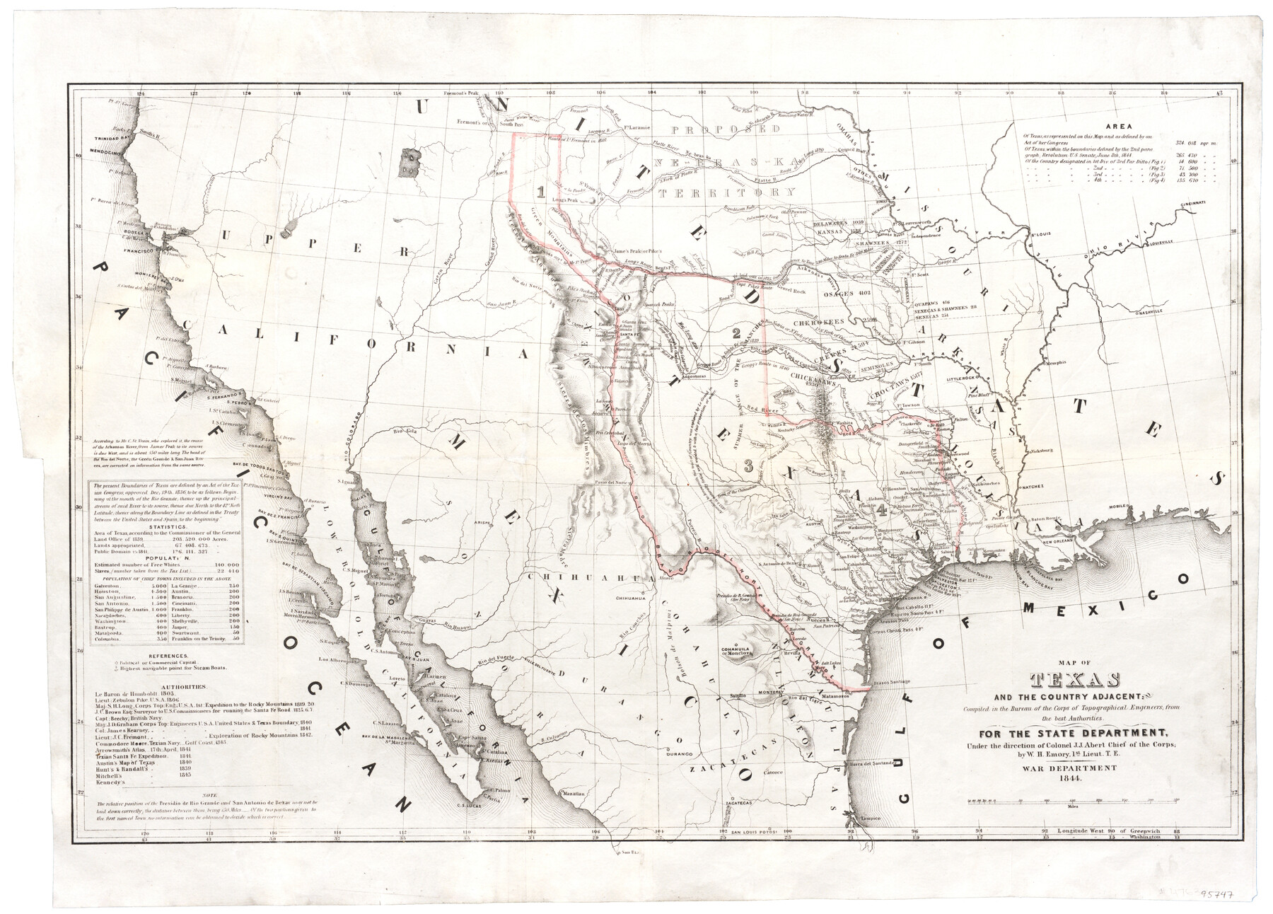
Map of Texas and the Country Adjacent: Compiled in the Bureau of the Corps of Topographical Engineers from the best Authorities
-
Map/Doc
95747
-
Collection
General Map Collection
-
Object Dates
1844 (Creation Date)
-
People and Organizations
War Department (Publisher)
W.H. Emory (Surveyor/Engineer)
J.J. Abert ()
-
Subjects
Military Republic of Texas
-
Height x Width
17.0 x 23.4 inches
43.2 x 59.4 cm
-
Medium
paper, etching/engraving/lithograph
-
Comments
Map was included in 28th Congress, 2nd Session, House Executive Doc. No. 98 (Congressional Serial Set No. 465) titled: "Message from the President of the United States [February 3, 1845], transmitting a report from the Secretary of State relative to the boundaries of Texas…"
Part of: General Map Collection
Flight Mission No. DQO-8K, Frame 56, Galveston County

Print $20.00
- Digital $50.00
Flight Mission No. DQO-8K, Frame 56, Galveston County
1952
Size 18.7 x 17.6 inches
Map/Doc 85163

Briscoe County Sketch File L

Print $40.00
- Digital $50.00
Briscoe County Sketch File L
1935
Size 30.4 x 27.4 inches
Map/Doc 11009
Jefferson County Rolled Sketch 32

Print $40.00
- Digital $50.00
Jefferson County Rolled Sketch 32
1955
Size 26.4 x 49.3 inches
Map/Doc 9295
Sectional Map No. 5 of the lands and of the line of the Texas & Pacific Ry. Co. in part of El Paso County

Print $20.00
- Digital $50.00
Sectional Map No. 5 of the lands and of the line of the Texas & Pacific Ry. Co. in part of El Paso County
1885
Size 22.5 x 17.9 inches
Map/Doc 2305
Floyd County Sketch File 4

Print $48.00
- Digital $50.00
Floyd County Sketch File 4
1886
Size 15.4 x 13.9 inches
Map/Doc 22690
Hemphill County Rolled Sketch 15

Print $20.00
- Digital $50.00
Hemphill County Rolled Sketch 15
1961
Size 44.7 x 21.5 inches
Map/Doc 6194
Zapata County Working Sketch 20

Print $20.00
- Digital $50.00
Zapata County Working Sketch 20
1979
Size 20.9 x 18.5 inches
Map/Doc 62071
Mapa de la Sierra Gorda y Costa de el Seno Mexicano, desde la Ciudad de Querétaro, que se halla situada cerca de los veinte y un grados, hasta los veinte y ocho y medio en que esta la Bahia de el Espiritu Santo, sus Ríos, Ensenadas, y Fronteras

Mapa de la Sierra Gorda y Costa de el Seno Mexicano, desde la Ciudad de Querétaro, que se halla situada cerca de los veinte y un grados, hasta los veinte y ocho y medio en que esta la Bahia de el Espiritu Santo, sus Ríos, Ensenadas, y Fronteras
1747
Size 31.4 x 24.5 inches
Map/Doc 94267
Jefferson County Sketch File 45

Print $20.00
- Digital $50.00
Jefferson County Sketch File 45
1933
Size 16.7 x 33.0 inches
Map/Doc 11879
Flight Mission No. CRK-5P, Frame 161, Refugio County

Print $20.00
- Digital $50.00
Flight Mission No. CRK-5P, Frame 161, Refugio County
1956
Size 18.5 x 22.4 inches
Map/Doc 86942
Edwards County Sketch File 43

Print $20.00
- Digital $50.00
Edwards County Sketch File 43
1947
Size 17.4 x 18.2 inches
Map/Doc 11441
You may also like
Tarrant County Working Sketch 14

Print $20.00
- Digital $50.00
Tarrant County Working Sketch 14
1989
Size 26.5 x 31.0 inches
Map/Doc 62431
Map of Rains County, Texas

Print $3.00
- Digital $50.00
Map of Rains County, Texas
1880
Size 11.7 x 12.0 inches
Map/Doc 541
Lake Worth Boundary

Print $20.00
- Digital $50.00
Lake Worth Boundary
Size 19.5 x 33.2 inches
Map/Doc 62211
Map of Tom Green Co.

Print $40.00
- Digital $50.00
Map of Tom Green Co.
1880
Size 42.3 x 51.2 inches
Map/Doc 80136
Refugio County

Print $20.00
- Digital $50.00
Refugio County
1883
Size 20.1 x 28.9 inches
Map/Doc 3984
Map of the River Sabine from Logan's Ferry to 32nd Degree of North Latitude

Print $20.00
Map of the River Sabine from Logan's Ferry to 32nd Degree of North Latitude
1841
Size 21.4 x 27.8 inches
Map/Doc 88902
Reference Book of Burnet's, [Vehlein's] & Zavala's Colonies
![94554, Reference Book of Burnet's, [Vehlein's] & Zavala's Colonies, Historical Volumes](https://historictexasmaps.com/wmedia_w700/pdf_converted_jpg/qi_pdf_thumbnail_39143.jpg)
Reference Book of Burnet's, [Vehlein's] & Zavala's Colonies
Map/Doc 94554
Map showing surveys made on Mustang Island

Print $40.00
- Digital $50.00
Map showing surveys made on Mustang Island
1945
Size 54.7 x 21.0 inches
Map/Doc 2948
General Highway Map, Borden County, Texas

Print $20.00
General Highway Map, Borden County, Texas
1961
Size 18.3 x 25.0 inches
Map/Doc 79377
Real County Working Sketch 89

Print $20.00
- Digital $50.00
Real County Working Sketch 89
Size 28.0 x 37.1 inches
Map/Doc 71981
[H. & T. C. Block 47, Sections 52- 56]
![91488, [H. & T. C. Block 47, Sections 52- 56], Twichell Survey Records](https://historictexasmaps.com/wmedia_w700/maps/91488-1.tif.jpg)
Print $3.00
- Digital $50.00
[H. & T. C. Block 47, Sections 52- 56]
Size 9.4 x 14.4 inches
Map/Doc 91488
Stonewall County Working Sketch 30

Print $20.00
- Digital $50.00
Stonewall County Working Sketch 30
1982
Size 28.6 x 29.0 inches
Map/Doc 62337