Briscoe County Sketch File L
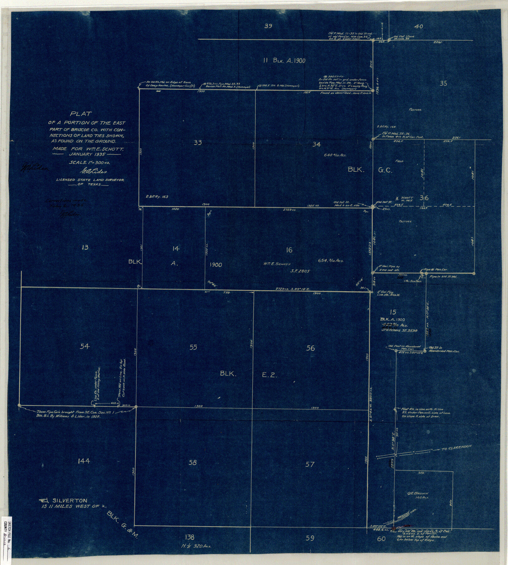
Plat of a portion of the east part of Briscoe Co. with connections of land ties shown, as found on the ground made for Wm. E. Schott [Northeast corner of Block E2 and part of Block GC]
-
Map/Doc
11009
-
Collection
General Map Collection
-
Object Dates
1935 (Creation Date)
1935/2/18 (File Date)
-
People and Organizations
G.A. Lider (Surveyor/Engineer)
-
Counties
Briscoe
-
Subjects
Surveying Sketch File
-
Height x Width
30.4 x 27.4 inches
77.2 x 69.6 cm
-
Medium
blueprint/diazo
-
Scale
1" = 300 varas
-
Features
Road to Clarendon
Mexican Creek
Part of: General Map Collection
Hudspeth County Rolled Sketch 73

Print $40.00
- Digital $50.00
Hudspeth County Rolled Sketch 73
1992
Size 38.9 x 49.3 inches
Map/Doc 9236
Erath County Working Sketch 44

Print $20.00
- Digital $50.00
Erath County Working Sketch 44
1981
Size 29.7 x 30.4 inches
Map/Doc 69125
Cooke County Working Sketch 5

Print $20.00
- Digital $50.00
Cooke County Working Sketch 5
1928
Size 16.1 x 17.2 inches
Map/Doc 68242
Chambers County Sketch File 51

Print $35.00
- Digital $50.00
Chambers County Sketch File 51
1935
Size 14.3 x 9.0 inches
Map/Doc 18068
Presidio County Working Sketch 144

Print $20.00
- Digital $50.00
Presidio County Working Sketch 144
1990
Size 20.4 x 26.6 inches
Map/Doc 71822
Clay County Sketch File 35

Print $3.00
- Digital $50.00
Clay County Sketch File 35
Size 10.3 x 12.1 inches
Map/Doc 18463

Presidio County Rolled Sketch 75

Print $20.00
- Digital $50.00
Presidio County Rolled Sketch 75
1938
Size 24.8 x 20.0 inches
Map/Doc 7363
Jefferson County Working Sketch 11

Print $20.00
- Digital $50.00
Jefferson County Working Sketch 11
1943
Size 46.6 x 43.0 inches
Map/Doc 66554
South Part of Webb County

Print $40.00
- Digital $50.00
South Part of Webb County
1984
Size 41.2 x 61.5 inches
Map/Doc 77453
Right of Way and Track Map, the Missouri, Kansas & Texas Ry. Of Texas operated by the Missouri, Kansas & Texas Ry. Of Texas, Houston Division

Print $40.00
- Digital $50.00
Right of Way and Track Map, the Missouri, Kansas & Texas Ry. Of Texas operated by the Missouri, Kansas & Texas Ry. Of Texas, Houston Division
1918
Size 24.7 x 73.8 inches
Map/Doc 64565
Upton County Sketch File 34

Print $40.00
- Digital $50.00
Upton County Sketch File 34
1941
Size 16.2 x 12.2 inches
Map/Doc 38884
You may also like
Chambers County Rolled Sketch 19

Print $20.00
- Digital $50.00
Chambers County Rolled Sketch 19
Size 39.8 x 44.4 inches
Map/Doc 8588
Mitchell County Boundary File 66

Print $13.00
- Digital $50.00
Mitchell County Boundary File 66
Size 7.9 x 3.7 inches
Map/Doc 57372
Part of Laguna Madre in Cameron County, showing Subdivision for Mineral Development

Print $20.00
- Digital $50.00
Part of Laguna Madre in Cameron County, showing Subdivision for Mineral Development
1963
Size 45.8 x 36.0 inches
Map/Doc 1926
Montgomery County Working Sketch 14

Print $20.00
- Digital $50.00
Montgomery County Working Sketch 14
1934
Size 18.5 x 20.1 inches
Map/Doc 71121
Bosque County Working Sketch 24

Print $20.00
- Digital $50.00
Bosque County Working Sketch 24
1994
Size 34.6 x 47.3 inches
Map/Doc 67458
The Mexican Department of Brazos. On the Eve of Texas Independence, 1836

Print $20.00
The Mexican Department of Brazos. On the Eve of Texas Independence, 1836
2020
Size 19.7 x 21.7 inches
Map/Doc 95976

[Sketch showing Jeff Davis County, Blocks 1, 2, 3, 4, 360, 363 and JG1]
![91776, [Sketch showing Jeff Davis County, Blocks 1, 2, 3, 4, 360, 363 and JG1], Twichell Survey Records](https://historictexasmaps.com/wmedia_w700/maps/91776-1.tif.jpg)
Print $20.00
- Digital $50.00
[Sketch showing Jeff Davis County, Blocks 1, 2, 3, 4, 360, 363 and JG1]
Size 20.5 x 13.7 inches
Map/Doc 91776
Randall County

Print $20.00
- Digital $50.00
Randall County
1958
Size 46.2 x 39.9 inches
Map/Doc 95620
Young County Working Sketch 22

Print $20.00
- Digital $50.00
Young County Working Sketch 22
1965
Size 26.5 x 32.3 inches
Map/Doc 62045
Eastland County Working Sketch 10

Print $20.00
- Digital $50.00
Eastland County Working Sketch 10
1919
Size 20.2 x 16.3 inches
Map/Doc 68791
Kinney County

Print $40.00
- Digital $50.00
Kinney County
1955
Size 48.9 x 42.4 inches
Map/Doc 77342